Wasatch Plateau
The Wasatch Plateau is a plateau located southeast of the southernmost part of the Wasatch Range in central Utah, United States, that is part of the Colorado Plateau.[1]
Description[]
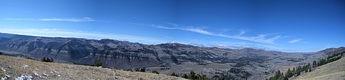
The plateau has an elevation of 8,825 feet (2,690 m)[1] and includes an area of 2,792 square miles (7,230 km2). Its highest point in the , with an elevation of 11,263 feet (3,433 m). The plateau is roughly bordered by the on the north, the Price Canyon on the northeast, the Castle Valley on the east and southeast, Interstate 70 on the south, the Plateau Valley and the on the southwest, and the Sanpete Valley on the northwest. The majority of the plateau is within the boundaries of the Manti-La Sal National Forest and is, therefore, managed by the United States Forest Service.[2][3]
See also[]
References[]
- ^ Jump up to: a b U.S. Geological Survey Geographic Names Information System: Wasatch Plateau
- ^ "Wasatch Plateau". Peakbagger.com. Retrieved 25 Mar 2019.
- ^ "Wasatch Plateau". SummitPost.org. Retrieved 25 Mar 2019.
External links[]
![]() Media related to Wasatch Plateau at Wikimedia Commons
Media related to Wasatch Plateau at Wikimedia Commons
| hide Authority control | |
|---|---|
| General |
|
| National libraries | |
Coordinates: 39°18′41″N 111°20′12″W / 39.31139°N 111.33667°W

This article about a specific stratigraphic formation in Utah is a stub. You can help Wikipedia by . |
- Plateaus of Utah
- Landforms of Carbon County, Utah
- Landforms of Sanpete County, Utah
- Landforms of Utah County, Utah
- Manti-La Sal National Forest
- Utah geologic formation stubs