Waterlooplein metro station
Waterlooplein | |||||||||||||||||||
|---|---|---|---|---|---|---|---|---|---|---|---|---|---|---|---|---|---|---|---|
 | |||||||||||||||||||
| Location | Waterlooplein, Amsterdam, | ||||||||||||||||||
| Coordinates | 52°22′02″N 4°54′06″E / 52.36722°N 4.90167°ECoordinates: 52°22′02″N 4°54′06″E / 52.36722°N 4.90167°E | ||||||||||||||||||
| Owned by | GVB | ||||||||||||||||||
| Line(s) | 9, 14 (Tram) 51, 53, 54 (Metro) | ||||||||||||||||||
| Platforms | 2 | ||||||||||||||||||
| Tracks | 2 | ||||||||||||||||||
| Other information | |||||||||||||||||||
| Fare zone | 5700 (Centrum) | ||||||||||||||||||
| History | |||||||||||||||||||
| Opened | 11 October 1980 | ||||||||||||||||||
| Services | |||||||||||||||||||
| |||||||||||||||||||

Waterlooplein is an Amsterdam Metro station in the centre of Amsterdam, Netherlands. The station is close to the Stopera, the city hall of Amsterdam.
The Station[]
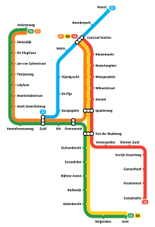
The station opened in 1980 and is served by 3 lines, the 51 (Amsterdam Centraal - Amstelveen), 53 (Amsterdam Centraal - Gaasperplas) and 54 (Amsterdam Centraal - Gein).
The station's location is close to the Waterlooplein, Rembrandt House Museum, the Stopera, Joods Historisch Museum, Hortus Botanicus and Hermitage Amsterdam.
The metro station is only accessible with an OV-chipkaart or GVB Travel Pass.
Tram services[]
- 9 - Amsterdam Centraal - City Centre - Waterlooplein - Plantage - Watergraafsmeer - Diemen Sniep
- 14 - Sloterpark - Rozengracht - City Centre - Waterlooplein - Plantage - Flevopark
Amsterdam Metro network
References[]
| Wikimedia Commons has media related to Metrostation Waterlooplein. |
- GVB website (in English)
Categories:
- Amsterdam Metro stations
- Railway stations opened in 1980