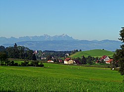
Weißensberg
This article needs additional citations for verification. (July 2021) |
Weißensberg | |
|---|---|
 Weißensberg | |
 Coat of arms | |
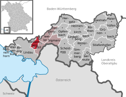
show Location of Weißensberg within Lindau district | |
 Weißensberg | |
| Coordinates: 47°34′N 9°43′E / 47.567°N 9.717°ECoordinates: 47°34′N 9°43′E / 47.567°N 9.717°E | |
| Country | Germany |
| State | Bavaria |
| Admin. region | Schwaben |
| District | Lindau |
| Government | |
| • Mayor (2020–26) | Hans Kern[1] |
| Area | |
| • Total | 7.84 km2 (3.03 sq mi) |
| Highest elevation | 530 m (1,740 ft) |
| Lowest elevation | 470 m (1,540 ft) |
| Population (2020-12-31)[2] | |
| • Total | 2,674 |
| • Density | 340/km2 (880/sq mi) |
| Time zone | UTC+01:00 (CET) |
| • Summer (DST) | UTC+02:00 (CEST) |
| Postal codes | 88138 |
| Dialling codes | 08389 |
| Vehicle registration | LI |
| Website | www.weissensberg.de |

Weißensberg is a municipality in the district of Lindau in Bavaria in Germany.
Until 1955, Weißensberg belonged to the Bavarian district of Lindau, which was in the French occupation zone and had special benefits. The entire tax revenue remained “in the state of Lindau” and you could feel the political and economic fate of the highly esteemed District President Zwiesler everywhere. After the currency reform, all school desks were replaced, and in 1949 a third classroom was set up on the first floor.
References[]
- ^ Liste der ersten Bürgermeister/Oberbürgermeister in kreisangehörigen Gemeinden, Bayerisches Landesamt für Statistik, 15 July 2021.
- ^ "Tabellenblatt "Daten 2", Statistischer Bericht A1200C 202041 Einwohnerzahlen der Gemeinden, Kreise und Regierungsbezirke". Bayerisches Landesamt für Statistik (in German). June 2021.
| show Towns and municipalities in Lindau (district) |
|---|
| show Authority control |
|---|
This Lindau district location article is a stub. You can help Wikipedia by . |
Categories:
- Municipalities in Bavaria
- Lindau (district)
- Swabia (Bavaria) geography stubs