Wenden Voivodeship
| Wenden Voivodeship Województwo wendeńskie | |||||||||
|---|---|---|---|---|---|---|---|---|---|
| Voivodeship of Livonia1 | |||||||||
| 1598–1621 | |||||||||
 Coat of arms
| |||||||||
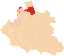 Wenden Voivodeship in the Duchy of Livonia. | |||||||||
| Capital | Wenden | ||||||||
| Area | |||||||||
• | 30,000 km2 (12,000 sq mi) | ||||||||
| History | |||||||||
| History | |||||||||
• Established | 1598 | ||||||||
| 1621 | |||||||||
| |||||||||
| 1 The Duchy of Livonia was a vassal to the Grand Duchy of Lithuania until the Union of Lublin in 1569, and after that a part of the Polish–Lithuanian Commonwealth. | |||||||||
Wenden Voivodeship (Polish: Województwo wendeńskie)[1] was a unit of administrative division and local government in the Duchy of Livonia, part of the Polish–Lithuanian Commonwealth. It was formed in 1598 by King Sigismund III Vasa, out of Wenden Presidency (Province), which had been created in 1582 by King Stephen Báthory, after the Truce of Yam-Zapolsky. The voivodeship remained in the Commonwealth until the Swedish Empire's conquest of Livonia in the 1620s. The unconquered remainder of Livonia was named Inflanty Voivodeship, and continued to be part of the Commonwealth until its first partition in 1772.
Officially, Wenden Voivodeship belonged to Poland–Lithuania until the Treaty of Oliva in 1660. Its capital was Wenden, where local sejmiks of the nobility (see szlachta) took place. Wenden Voivodeship elected two deputies to the Sejm of the Polish–Lithuanian Commonwealth. Even though it no longer belonged to the Commonwealth after the Swedish conquest, its voivodes continued to be named by Polish kings until the final partition of Poland (1795), as the so-called "fictitious titles" (Polish: urzędy fikcyjne).
Major cities, towns and castles of Wenden Voivodeship were: Cēsis (Kies, Wenden), Riga, Koknese (Kokenhausen), Salaspils (Kircholm), Daugavpils (Dyneburg), Rēzekne (Rzezyca, Rositten), Viļaka (Marienhausen), Gulbene (Schwanenburg), Ludza (Lucyn), Krustpils (Kreutzburg).
Voivodes of Wenden[]
The seat of the voivode was Wenden (Cēsis).
- 1598–1602 Jürgen von Farensbach
- 1620–1622
- 1627–1641
- 1641–1643 Tomasz Sapieha
- 1643–1648
- (died 1659)
References[]
- ^ Niesiecki, Kasper (1846). Herbarz polski Kaspra Niesieckiego (in Polish). Waif. p. 228.
| Province of Greater Poland |
|  |
|---|---|---|
| Province of Lesser Poland | ||
| Grand Duchy of Lithuania | ||
| Polish Livonia | ||
| Fiefs | ||
Coordinates: 57°18′34″N 25°16′22″E / 57.309343°N 25.272847°E

- States and territories established in 1598
- States and territories disestablished in the 1620s
- Voivodeships of the Polish–Lithuanian Commonwealth
- Duchy of Livonia
- 1598 establishments in the Polish–Lithuanian Commonwealth
- 1621 disestablishments in the Polish–Lithuanian Commonwealth
- Organisations based in Livonia