West Fourth Street–Washington Square station
West 4 Street– Washington Square | ||||||||||||||||||||||||||||||||||||||||||||||||||||||||||||||||||||||||||||||||||||||||||||||||||||||||||||||||||||||||||||||||||||||||||||||||||||||||||||||||||||||||||||||||||||||||||||||||||||||||||||||||||||||||||||||||
|---|---|---|---|---|---|---|---|---|---|---|---|---|---|---|---|---|---|---|---|---|---|---|---|---|---|---|---|---|---|---|---|---|---|---|---|---|---|---|---|---|---|---|---|---|---|---|---|---|---|---|---|---|---|---|---|---|---|---|---|---|---|---|---|---|---|---|---|---|---|---|---|---|---|---|---|---|---|---|---|---|---|---|---|---|---|---|---|---|---|---|---|---|---|---|---|---|---|---|---|---|---|---|---|---|---|---|---|---|---|---|---|---|---|---|---|---|---|---|---|---|---|---|---|---|---|---|---|---|---|---|---|---|---|---|---|---|---|---|---|---|---|---|---|---|---|---|---|---|---|---|---|---|---|---|---|---|---|---|---|---|---|---|---|---|---|---|---|---|---|---|---|---|---|---|---|---|---|---|---|---|---|---|---|---|---|---|---|---|---|---|---|---|---|---|---|---|---|---|---|---|---|---|---|---|---|---|---|---|---|---|---|---|---|---|---|---|---|---|---|---|---|---|---|---|
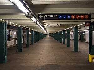 The station's mezzanine | ||||||||||||||||||||||||||||||||||||||||||||||||||||||||||||||||||||||||||||||||||||||||||||||||||||||||||||||||||||||||||||||||||||||||||||||||||||||||||||||||||||||||||||||||||||||||||||||||||||||||||||||||||||||||||||||||
| Station statistics | ||||||||||||||||||||||||||||||||||||||||||||||||||||||||||||||||||||||||||||||||||||||||||||||||||||||||||||||||||||||||||||||||||||||||||||||||||||||||||||||||||||||||||||||||||||||||||||||||||||||||||||||||||||||||||||||||
| Address | West Third Street & Sixth Avenue New York, NY 10014 (main station entrance) | |||||||||||||||||||||||||||||||||||||||||||||||||||||||||||||||||||||||||||||||||||||||||||||||||||||||||||||||||||||||||||||||||||||||||||||||||||||||||||||||||||||||||||||||||||||||||||||||||||||||||||||||||||||||||||||||
| Borough | Manhattan | |||||||||||||||||||||||||||||||||||||||||||||||||||||||||||||||||||||||||||||||||||||||||||||||||||||||||||||||||||||||||||||||||||||||||||||||||||||||||||||||||||||||||||||||||||||||||||||||||||||||||||||||||||||||||||||||
| Locale | Greenwich Village | |||||||||||||||||||||||||||||||||||||||||||||||||||||||||||||||||||||||||||||||||||||||||||||||||||||||||||||||||||||||||||||||||||||||||||||||||||||||||||||||||||||||||||||||||||||||||||||||||||||||||||||||||||||||||||||||
| Coordinates | 40°43′54″N 74°00′03″W / 40.731682°N 74.000945°WCoordinates: 40°43′54″N 74°00′03″W / 40.731682°N 74.000945°W | |||||||||||||||||||||||||||||||||||||||||||||||||||||||||||||||||||||||||||||||||||||||||||||||||||||||||||||||||||||||||||||||||||||||||||||||||||||||||||||||||||||||||||||||||||||||||||||||||||||||||||||||||||||||||||||||
| Division | B (IND)[1] | |||||||||||||||||||||||||||||||||||||||||||||||||||||||||||||||||||||||||||||||||||||||||||||||||||||||||||||||||||||||||||||||||||||||||||||||||||||||||||||||||||||||||||||||||||||||||||||||||||||||||||||||||||||||||||||||
| Line | IND Sixth Avenue Line IND Eighth Avenue Line | |||||||||||||||||||||||||||||||||||||||||||||||||||||||||||||||||||||||||||||||||||||||||||||||||||||||||||||||||||||||||||||||||||||||||||||||||||||||||||||||||||||||||||||||||||||||||||||||||||||||||||||||||||||||||||||||
| Services | A B C D E F M | |||||||||||||||||||||||||||||||||||||||||||||||||||||||||||||||||||||||||||||||||||||||||||||||||||||||||||||||||||||||||||||||||||||||||||||||||||||||||||||||||||||||||||||||||||||||||||||||||||||||||||||||||||||||||||||||
| Transit | ||||||||||||||||||||||||||||||||||||||||||||||||||||||||||||||||||||||||||||||||||||||||||||||||||||||||||||||||||||||||||||||||||||||||||||||||||||||||||||||||||||||||||||||||||||||||||||||||||||||||||||||||||||||||||||||||
| Structure | Underground | |||||||||||||||||||||||||||||||||||||||||||||||||||||||||||||||||||||||||||||||||||||||||||||||||||||||||||||||||||||||||||||||||||||||||||||||||||||||||||||||||||||||||||||||||||||||||||||||||||||||||||||||||||||||||||||||
| Levels | 2 | |||||||||||||||||||||||||||||||||||||||||||||||||||||||||||||||||||||||||||||||||||||||||||||||||||||||||||||||||||||||||||||||||||||||||||||||||||||||||||||||||||||||||||||||||||||||||||||||||||||||||||||||||||||||||||||||
| Platforms | 4 island platforms (2 on each level) cross-platform interchange | |||||||||||||||||||||||||||||||||||||||||||||||||||||||||||||||||||||||||||||||||||||||||||||||||||||||||||||||||||||||||||||||||||||||||||||||||||||||||||||||||||||||||||||||||||||||||||||||||||||||||||||||||||||||||||||||
| Tracks | 8 (4 on each level) | |||||||||||||||||||||||||||||||||||||||||||||||||||||||||||||||||||||||||||||||||||||||||||||||||||||||||||||||||||||||||||||||||||||||||||||||||||||||||||||||||||||||||||||||||||||||||||||||||||||||||||||||||||||||||||||||
| Other information | ||||||||||||||||||||||||||||||||||||||||||||||||||||||||||||||||||||||||||||||||||||||||||||||||||||||||||||||||||||||||||||||||||||||||||||||||||||||||||||||||||||||||||||||||||||||||||||||||||||||||||||||||||||||||||||||||
| Opened | September 10, 1932[2] (upper level) January 1, 1936 (lower level) | |||||||||||||||||||||||||||||||||||||||||||||||||||||||||||||||||||||||||||||||||||||||||||||||||||||||||||||||||||||||||||||||||||||||||||||||||||||||||||||||||||||||||||||||||||||||||||||||||||||||||||||||||||||||||||||||
| Station code | 167[3] | |||||||||||||||||||||||||||||||||||||||||||||||||||||||||||||||||||||||||||||||||||||||||||||||||||||||||||||||||||||||||||||||||||||||||||||||||||||||||||||||||||||||||||||||||||||||||||||||||||||||||||||||||||||||||||||||
| Accessible | ||||||||||||||||||||||||||||||||||||||||||||||||||||||||||||||||||||||||||||||||||||||||||||||||||||||||||||||||||||||||||||||||||||||||||||||||||||||||||||||||||||||||||||||||||||||||||||||||||||||||||||||||||||||||||||||||
| Opposite- direction transfer | Yes | |||||||||||||||||||||||||||||||||||||||||||||||||||||||||||||||||||||||||||||||||||||||||||||||||||||||||||||||||||||||||||||||||||||||||||||||||||||||||||||||||||||||||||||||||||||||||||||||||||||||||||||||||||||||||||||||
| Traffic | ||||||||||||||||||||||||||||||||||||||||||||||||||||||||||||||||||||||||||||||||||||||||||||||||||||||||||||||||||||||||||||||||||||||||||||||||||||||||||||||||||||||||||||||||||||||||||||||||||||||||||||||||||||||||||||||||
| 2019 | 14,063,633[5] | |||||||||||||||||||||||||||||||||||||||||||||||||||||||||||||||||||||||||||||||||||||||||||||||||||||||||||||||||||||||||||||||||||||||||||||||||||||||||||||||||||||||||||||||||||||||||||||||||||||||||||||||||||||||||||||||
| Rank | 19 out of 424[5] | |||||||||||||||||||||||||||||||||||||||||||||||||||||||||||||||||||||||||||||||||||||||||||||||||||||||||||||||||||||||||||||||||||||||||||||||||||||||||||||||||||||||||||||||||||||||||||||||||||||||||||||||||||||||||||||||
| Station succession | ||||||||||||||||||||||||||||||||||||||||||||||||||||||||||||||||||||||||||||||||||||||||||||||||||||||||||||||||||||||||||||||||||||||||||||||||||||||||||||||||||||||||||||||||||||||||||||||||||||||||||||||||||||||||||||||||
| Next north | 34th Street–Herald Square (6th Ave express): B 14th Street (8th Ave): A 14th Street (6th Ave local): F | |||||||||||||||||||||||||||||||||||||||||||||||||||||||||||||||||||||||||||||||||||||||||||||||||||||||||||||||||||||||||||||||||||||||||||||||||||||||||||||||||||||||||||||||||||||||||||||||||||||||||||||||||||||||||||||||
| Next south | Broadway–Lafayette Street (6th Ave): B Spring Street (8th Ave local): A Canal Street (8th Ave express): A | |||||||||||||||||||||||||||||||||||||||||||||||||||||||||||||||||||||||||||||||||||||||||||||||||||||||||||||||||||||||||||||||||||||||||||||||||||||||||||||||||||||||||||||||||||||||||||||||||||||||||||||||||||||||||||||||
| ||||||||||||||||||||||||||||||||||||||||||||||||||||||||||||||||||||||||||||||||||||||||||||||||||||||||||||||||||||||||||||||||||||||||||||||||||||||||||||||||||||||||||||||||||||||||||||||||||||||||||||||||||||||||||||||||
| ||||||||||||||||||||||||||||||||||||||||||||||||||||||||||||||||||||||||||||||||||||||||||||||||||||||||||||||||||||||||||||||||||||||||||||||||||||||||||||||||||||||||||||||||||||||||||||||||||||||||||||||||||||||||||||||||
| ||||||||||||||||||||||||||||||||||||||||||||||||||||||||||||||||||||||||||||||||||||||||||||||||||||||||||||||||||||||||||||||||||||||||||||||||||||||||||||||||||||||||||||||||||||||||||||||||||||||||||||||||||||||||||||||||
| ||||||||||||||||||||||||||||||||||||||||||||||||||||||||||||||||||||||||||||||||||||||||||||||||||||||||||||||||||||||||||||||||||||||||||||||||||||||||||||||||||||||||||||||||||||||||||||||||||||||||||||||||||||||||||||||||
West 4th Street Subway Station (IND) | ||||||||||||||||||||||||||||||||||||||||||||||||||||||||||||||||||||||||||||||||||||||||||||||||||||||||||||||||||||||||||||||||||||||||||||||||||||||||||||||||||||||||||||||||||||||||||||||||||||||||||||||||||||||||||||||||
U.S. National Register of Historic Places | ||||||||||||||||||||||||||||||||||||||||||||||||||||||||||||||||||||||||||||||||||||||||||||||||||||||||||||||||||||||||||||||||||||||||||||||||||||||||||||||||||||||||||||||||||||||||||||||||||||||||||||||||||||||||||||||||
| MPS | New York City Subway System MPS | |||||||||||||||||||||||||||||||||||||||||||||||||||||||||||||||||||||||||||||||||||||||||||||||||||||||||||||||||||||||||||||||||||||||||||||||||||||||||||||||||||||||||||||||||||||||||||||||||||||||||||||||||||||||||||||||
| NRHP reference No. | 05000223[6] | |||||||||||||||||||||||||||||||||||||||||||||||||||||||||||||||||||||||||||||||||||||||||||||||||||||||||||||||||||||||||||||||||||||||||||||||||||||||||||||||||||||||||||||||||||||||||||||||||||||||||||||||||||||||||||||||
| Added to NRHP | March 30, 2005 | |||||||||||||||||||||||||||||||||||||||||||||||||||||||||||||||||||||||||||||||||||||||||||||||||||||||||||||||||||||||||||||||||||||||||||||||||||||||||||||||||||||||||||||||||||||||||||||||||||||||||||||||||||||||||||||||


The West Fourth Street–Washington Square station is an express station and transfer stop on the IND Sixth Avenue and IND Eighth Avenue Lines of the New York City Subway, located at the intersection of West Fourth Street and Sixth Avenue (Avenue of the Americas) in Greenwich Village, Manhattan. It is served by:
- A, D, E, and F trains at all times;
- B and M trains on weekdays;
- C train at all times except late nights; and
- <F> train during rush hours in the peak direction.
History[]
Construction[]
New York City mayor John Francis Hylan's original plans for the Independent Subway System (IND), proposed in 1922, included building over 100 miles (160 km) of new lines and taking over nearly 100 miles (160 km) of existing lines, which would compete with the IRT and the Brooklyn–Manhattan Transit Corporation (BMT), the two major subway operators of the time.[7][8] The New York City Board of Transportation (NYCBOT) gave preliminary approval to the IND Eighth Avenue Line in 1924. This line consisted of a corridor connecting Inwood, Manhattan, to Downtown Brooklyn, running largely under Eighth Avenue but also paralleling Greenwich Avenue and Sixth Avenue in Lower Manhattan.[9][10] An additional line, the IND Sixth Avenue Line, was approved in 1925, running from Midtown Manhattan underneath Sixth Avenue, Houston Street, Essex Street, and the Rutgers Street Tunnel to Downtown Brooklyn.[11] The IND Sixth Avenue Line was designed to replace the elevated IRT Sixth Avenue Line.[12] The transfer hub between the Eighth Avenue and Sixth Avenue lines, at Sixth Avenue and West 4th Street in Greenwich Village, was named "West Fourth Street" as opposed to merely "Fourth Street" because the planners of the Independent Subway System believed there would be confusion between this station and "South Fourth Street", a proposed transfer station on the never-built IND Second System in Williamsburg, Brooklyn.[13]
Work on the IND Eighth Avenue Line began in 1925.[14] The first portion of the Sixth Avenue Line to be constructed, comprising the Houston–Essex Street Line south of the West Fourth Street station, officially started in May 1929.[15] Because of complexities in the construction of the Midtown section of the Sixth Avenue Line, that section did not begin construction until April 1935.[16]
Opening and modifications[]
The upper level of the West Fourth Street station opened on September 10, 1932, as part of the city-operated Independent Subway System (IND)'s initial segment, the Eighth Avenue Line between Chambers Street and 207th Street.[2][17] When the station opened in 1932, express (A) and local (AA) trains served the line; expresses did not run during late nights or Sundays.[2] When the IND Concourse Line opened on July 1, 1933,[18] the C was added to the express service, while all locals became CC trains to the Concourse Line.[19] The E was added to the local tracks south of 50th Street on August 19, 1933, when the IND Queens Boulevard Line opened.[20]
The lower level opened on January 1, 1936, as one of four stations on the first part of the Sixth Avenue Line. Two local tracks split from a junction with the Eighth Avenue Line south of West Fourth Street–Washington Square, running east under Houston Street and south under Essex Street to a temporary terminal at East Broadway.[21] Initially, E trains would split from the upper level and run to Church Avenue.[22][23] When further sections of the Sixth Avenue Line opened on December 15, 1940, the F train replaced the E train at the lower level of the West Fourth Street station.[24]
The Sixth Avenue Line's Midtown section, comprising the section between the West Fourth Street and 34th Street–Herald Square stations, originally did not have express tracks. On April 19, 1961, ground was broken for a $22 million project to build two express tracks between these two stations.[25] On November 26, 1967, the express tracks started to be used by the B and D trains. At that time, the first part of the Chrystie Street Connection opened, connecting the express tracks at the Broadway–Lafayette Street station one stop south to the Manhattan Bridge.[26] On July 1, 1968, another section of the Chrystie Street Connection opened, allowing Sixth and Eighth Avenue local trains to use the Williamsburg Bridge.[27] The Williamsburg Bridge connection has been used by the M train since 2010.[28]


Station layout[]
| G | Street level | Exit/entrance |
| B1 | Mezzanine | Fare control, station agents |
| B2 | Northbound local | ← ← ← |
| Island platform | ||
| Northbound express | ← | |
| Southbound express | | |
| Island platform | ||
| Southbound local | | |
| B3 | Mezzanine | Connection between platform levels |
| B4 | Northbound local | ← ← |
| Island platform | ||
| Northbound express | ← ← | |
| Southbound express | | |
| Island platform | ||
| Southbound local | | |

The West Fourth Street station was built by the IND as the major transfer point between its two Manhattan trunk lines. It can be considered the "heart" of the IND system as it is the location of the zero point on the IND chaining. It is a bi-level station with a connecting concourse between the two platform levels. The Eighth Avenue Line occupies the upper level, while the Sixth Avenue Line uses the lower level. Both levels use identical platform arrangements–two island platforms between four tracks, allowing for cross-platform interchanges between local and express trains in each direction.
There are three fare control areas – two at the northern end of the station, and one at the southern end. All lead directly to the Eighth Avenue Line on the upper level platforms; access to the Sixth Avenue Line on the lower level is via stairs and elevators from the upper level and/or the full-length mezzanine between the two levels. Several escalators are present, which go directly between one of the lower level platforms to its corresponding upper level platform. The elevators, added in April 2005 to make the station ADA-accessible, provide access to both levels and to the mezzanine.[29]
The track walls on both levels have a green trim line with a forest green border, though in many places the green tiles have been replaced with hunter green ones. Small tile captions reading "WEST 4" run below the trim lines at regular intervals. Hunter green I-beam columns run along all the platforms, alternating ones having the standard black station name plate; The signs read "West 4 Street", replacing the older signs which simply read "W4".
Exits[]
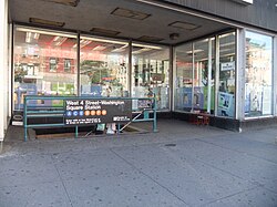
The station does not have an exit to Fourth Street itself anymore, though an exit formerly existed there.[30] The northern exits are on the northern side of 6th Avenue and Waverly Place. Two staircases go up to the northeast corner, both built into alcoves of stores, and one to the northwest corner. The southern exits are at West Third Street, on the east and west sides of 6th Avenue.[31]
- Two to the northwest corner (within building), one to the northeast corner (within building) of Sixth Avenue and Waverly Place[31]
- One to the east side of Sixth Avenue north of Waverly Place[31]
 One elevator and staircase on the northeast corner of Sixth Avenue and West Third Street[31]
- One on the west side of Sixth Avenue at West Third Street[31]
There are also four additional closed exits that directly led to the mezzanine. Two went to Washington Place, and the other two went to West 4th Street itself.[30] There is a fifth closed exit at one northern fare control area; it led to the southwestern corner of Greenwich Avenue and Sixth Avenue.
Nearby points of interest[]
- New York University
- Washington Square Park
- West Fourth Street Courts
References[]
- ^ "Glossary". Second Avenue Subway Supplemental Draft Environmental Impact Statement (SDEIS) (PDF). Vol. 1. Metropolitan Transportation Authority. March 4, 2003. pp. 1–2. Archived from the original (PDF) on February 26, 2021. Retrieved January 1, 2021.
- ^ a b c "List of the 28 Stations on the New 8th Av. Line". The New York Times. September 10, 1932. p. 6. ISSN 0362-4331. Retrieved April 21, 2020.
- ^ "Station Developers' Information". Metropolitan Transportation Authority. Retrieved June 13, 2017.
- ^ "Facts and Figures: Annual Subway Ridership 2014–2019". Metropolitan Transportation Authority. 2020. Retrieved May 26, 2020.
- ^ a b "Facts and Figures: Annual Subway Ridership 2014–2019". Metropolitan Transportation Authority. 2020. Retrieved May 26, 2020.
- ^ "NPS Focus". National Register of Historic Places. National Park Service. Retrieved January 25, 2012.
- ^ "Two Subway Routes Adopted by City". The New York Times. August 4, 1923. p. 9. ISSN 0362-4331. Retrieved August 1, 2019.
- ^ "Plans Now Ready to Start Subways". The New York Times. March 12, 1924. p. 1. ISSN 0362-4331. Retrieved August 1, 2019.
- ^ "Hylan Subway Plan Links Four Boroughs at $450,000,000 Cost". The New York Times. December 10, 1924. p. 1. ISSN 0362-4331. Retrieved June 29, 2018.
- ^ Raskin, Joseph B. (2013). The Routes Not Taken: A Trip Through New York City's Unbuilt Subway System. New York, New York: Fordham University Press. doi:10.5422/fordham/9780823253692.001.0001. ISBN 978-0-82325-369-2.
- ^ "New Subway Routes in Hylan Program to Cost $186,046,000 – Board of Transportation Adopts 22.90 Miles of Additional Lines – Total Now $345,629,000 – But the Entire System Planned by Mayor Involves $700,000,000 – Description of Routes – Heaviest Expenditures Will Be Made on Tunnels – No Allowance for Equipment – New Subway Routes to Cost $186,046,000". The New York Times. March 21, 1925. ISSN 0362-4331. Retrieved April 8, 2018.
- ^ "Delaney For Razing Elevated Line Now; Work in 6th Av. Could Begin in Six Months if Condemnation Started at Once, He Says. Sees Cut In Subway Cost Eliminating Need for Underpinning Would Save $4,000,000 and Speed Construction, He Holds". The New York Times. January 11, 1930. ISSN 0362-4331. Retrieved April 27, 2018.
- ^ Pollak, Michael (September 12, 2008). "F. Y. I." The New York Times. Retrieved August 5, 2009.
- ^ "Will Break Ground Today for New Uptown Subway". The New York Times. March 14, 1925. p. 15. ISSN 0362-4331. Retrieved June 29, 2018.
- ^ "East Side Subway Started By Mayor; He Breaks Ground for Crosstown System at Second Av. and East Houston St. Miller Hails Project Sees Area Rejuvenated by Line and City's Plan to Raze Old Tenements". The New York Times. May 2, 1929. ISSN 0362-4331. Retrieved April 28, 2018.
- ^ "New Subway Line on 6th Ave. Opens at Midnight Fete". The New York Times. December 15, 1940. p. 1. ISSN 0362-4331. Retrieved October 7, 2011.
- ^ Crowell, Paul (September 10, 1932). "Gay Midnight Crowd Rides First Trains In The New Subway: Throngs at Station an Hour Before Time, Rush Turnstiles When Chains are Dropped" (PDF). New York Times. Retrieved November 8, 2015.
- ^ "New Bronx Subway Starts Operation". The New York Times. July 1, 1933. p. 15. ISSN 0362-4331. Retrieved June 29, 2018.
- ^ Station Guide, Independent City Owned Rapid Transit Railroad (Map) (ca. 1937 ed.). Courtesy of the Board of Transportation of N.Y.C., printed in the Clarified Telephone Directories (Red Books) for New York City.
{{cite map}}: External link in|title= - ^ "Two Subway Units Open at Midnight". The New York Times. August 18, 1933. p. 17. ISSN 0362-4331. Retrieved June 29, 2018.
- ^ "LaGuardia Opens New Subway Link". The New York Times. January 2, 1936. p. 1. ISSN 0362-4331. Retrieved October 7, 2011.
- ^ "Two Subway Links Start Wednesday". The New York Times. April 6, 1936. p. 23. ISSN 0362-4331. Retrieved October 7, 2011.
- ^ "New Subway Link Opened by Mayor". The New York Times. April 9, 1936. p. 23. ISSN 0362-4331. Retrieved October 7, 2011.
- ^ "The New Subway Routes". The New York Times. December 15, 1940. ISSN 0362-4331. Retrieved April 15, 2018.
- ^ Levey, Stanley (April 19, 1961). "Construction of New IND Tunnel For 6th Ave. Line Begins Today; Express Tracks Deep Under Street to Run From 4th to 34th St. – 1964 Finish Set for $22,000,000 Job". The New York Times. ISSN 0362-4331. Retrieved April 28, 2018.
- ^ Perlmutter, Emanuel (November 27, 1967). "BMT-IND Changes Bewilder Many – Transit Authority Swamped With Calls From Riders as New System Starts". The New York Times. ISSN 0362-4331. Retrieved August 23, 2015.
- ^ Hofmann, Paul (July 1, 1968). "Skip-Stop Subway Begins Run Today – KK Line Links 3 Boroughs – Other Routes Changed". The New York Times. ISSN 0362-4331. Retrieved November 27, 2016.
- ^ "Modifications to 2010 NYC Transit Service Reductions" (PDF). mta.info. New York City Transit. March 19, 2010. pp. 4–5. Retrieved August 30, 2016.
- ^ Chan, Sewell (October 29, 2005). "New Elevators in Subways Are Delayed". The New York Times. Retrieved September 13, 2015.
- ^ a b Review of the A and C Lines (PDF) (Report). Metropolitan Transportation Authority. December 11, 2015. Archived from the original (PDF) on February 3, 2020. Retrieved January 19, 2016.
- ^ a b c d e "MTA Neighborhood Maps: West VIllage" (PDF). Metropolitan Transportation Authority. 2015. Retrieved September 13, 2015.
External links[]
| Wikimedia Commons has media related to West Fourth Street – Washington Square (New York City Subway). |
nycsubway.org
- nycsubway.org – IND 8th Avenue: West Fourth Street/Washington Square
- nycsubway.org – IND 6th Avenue: West Fourth Street/Washington Square
Station Reporter
- Station Reporter – A Lefferts
- Station Reporter – A Rockaway
- Station Reporter – B Train
- Station Reporter — C Train
- Station Reporter – D Train
- Station Reporter – E Train
- Station Reporter — F Train
- Station Reporter – M Train
Google Maps Street View
Stations of the New York City Subway, by line (physical trackage) | |||||||||||
|---|---|---|---|---|---|---|---|---|---|---|---|
| Sixth Ave. Line |
| ||||||||||
| Eighth Ave. Line |
| ||||||||||
| |||||||||||
U.S. National Register of Historic Places in New York | ||
|---|---|---|
| Topics |
|  |
| Lists by county |
| |
| Lists by city |
| |
| Other lists | ||
| ||
- Accessible New York City Subway stations
- IND Eighth Avenue Line stations
- IND Sixth Avenue Line stations
- Sixth Avenue
- Greenwich Village
- Railway and subway stations on the National Register of Historic Places in Manhattan
- New York City Subway stations in Manhattan
- New York City Subway stations located underground
- Railway stations in the United States opened in 1932
- 1932 establishments in New York City
- New York City Subway transfer stations
- West Village
- New York City Subway stations at university and college campuses