White Nothe
| White Nothe | |
|---|---|
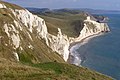
 White Nothe from the shore below the undercliff | |
 Location in Dorset | |
| Location | Dorset, England |
| Coordinates | 50°37′38.2″N 2°19′23.1″W / 50.627278°N 2.323083°WCoordinates: 50°37′38.2″N 2°19′23.1″W / 50.627278°N 2.323083°W |
| Elevation | 450 feet (160 m)[1] |

White Nothe (meaning "White Nose") is a chalk headland on the English Channel coast at the eastern end of Ringstead Bay, east of Weymouth in Dorset, England. The area is well known for its geology and fossils. Its flanks are the result of prehistoric landslides and the inaccessible slopes of the undercliff provide a secluded wildlife habitat.
A zigzag path up the cliff is believed to be one of the locations alluded to as a smuggler's path in the British children's book Moonfleet by J. Meade Falkner. Walking to the base of White Nothe along the shore from Ringstead Bay is possible, but it is cut off at high tide, so much care should be taken. At the top of the Smugglers path, a protruding nose shape comes out of the white cliff, giving the name to the area.
The area is partly owned by the National Trust.[2] From the top of White Nothe, to the east, the chalk headland of Bat's Head can be viewed. Walking east along a clifftop path below the summit of Chaldon Hill is possible to Durdle Door and Lulworth Cove.[3] The Isle of Portland can be seen to the southwest across the sea.
Immediately to the northwest of White Nothe is the Burning Cliff,[4] which from 1826 smouldered with an underground fire for several years due to the bituminous shale.[5]
Situated at the top of White Nothe is a World War II pillbox, constructed in 1940–41 of brick and concrete, as part of the anti-invasion measures. Unusually, the structure is also fitted with a Royal Observer Corps observation post built on top, which was to spot and report aircraft.[6] There is also a row of former coastguards' cottages.
White Nothe has featured in artworks.[7][8]
Gallery[]

White Nothe from Ringstead beach

White Nothe undercliff and Ringstead Bay from the Smugglers Path

The Smugglers' Path

The headland from the shore below the undercliff

The west side of the headland at sea level
View east from White Nothe

The headland from the shore below the undercliff


See also[]
References[]
- ^ "White Nothe Beach". thebeachguide. UK. Retrieved 20 January 2022.
- ^ West, Ian M. (2 April 2009). "Ringstead Bay to White Nothe". Geology of the Wessex Coast: Jurassic Coast, Dorset and East Devon World Heritage Site – Internet field guide. UK: National Oceanography Centre, Southampton University.
- ^ "Walk – Durdle Door & White Nothe". www.southwestcoastpath.org.uk. UK: The South West Coast Path National Trail. Retrieved 18 October 2016.
- ^ "Burning Cliff, West Dorset (DT2 8NG)". getoutside.ordnancesurvey.co.uk. UK: Ordnance Survey. Retrieved 20 January 2022.
- ^ West, Ian M. (6 June 2014). "Burning Cliff, Holworth, Ringstead Bay, Near Weymouth, 1826". Burning Cliffs of Dorset – Oil-Shale Fires. Geology of the Wessex Coast of Southern England. UK: University of Southampton. Retrieved 21 January 2022.
- ^ Historic England. "Monument No. 1419125". Research records (formerly PastScape). Retrieved 7 October 2015.
- ^ Catherine Ouless (1879–1961). "White Nothe, Ringstead, Dorset". Art UK. Dorset Museum. Retrieved 20 January 2022.
- ^ Gardiner, Jeremy (25 March 2019). "White Nothe III, watercolour by Jeremy Gardiner". jeremygardiner.co.uk. UK. Retrieved 20 January 2022.
External links[]
| Wikimedia Commons has media related to White Nothe. |
- White Nothe information from the governmental Joint Nature Conservation Committee (JNCC)
- Ringstead Bay to White Nothe from Ian West's Geology of the Wessex Coast internet field guide
- White Nothe, Ringstead walk from Walks4softies
- Headlands of Dorset
- National Trust properties in Dorset
- Jurassic Coast