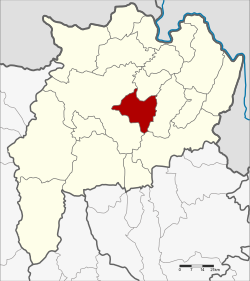
Wiang Chai District
Wiang Chai
เวียงชัย | |
|---|---|
 District location in Chiang Rai Province | |
| Coordinates: 19°52′59″N 99°55′59″E / 19.88306°N 99.93306°ECoordinates: 19°52′59″N 99°55′59″E / 19.88306°N 99.93306°E | |
| Country | Thailand |
| Province | Chiang Rai |
| Seat | Wiang Chai |
| Subdistricts | 5 |
| Mubans | 75 |
| Districtestablished | 17 June 1974 |
| Area | |
| • Total | 258.8 km2 (99.9 sq mi) |
| Population (2008) | |
| • Total | 43,968 |
| • Density | 169.9/km2 (440/sq mi) |
| Time zone | UTC+7 (ICT) |
| Postal code | 57210 |
| Geocode | 5702 |
Wiang Chai (Thai: เวียงชัย; IPA: [wīaŋ tɕʰāj]) is a district (amphoe) in the central part of Chiang Rai Province, northern Thailand.
Geography[]
Neighboring districts are (from the west clockwise): Mueang Chiang Rai, Wiang Chiang Rung, Phaya Mengrai, and Thoeng of Chiang Rai Province.
The important water resource is the Kok River.
History[]
The minor district (king amphoe) was created on 17 June 1974, when the three tambons Wiang Chai, Thung Ko, and Pha Ngam were split off from Mueang Chiang Rai District. [1] It was upgraded to a full district on 25 March 1979.[2]
Administration[]
The district is divided into five sub-districts (tambons), which are further subdivided into 75 villages (mubans). The township (thesaban tambon) Wiang Chai covers parts of tambons Wiang Chai and Mueang Chum. There are a further five tambon administrative organizations (TAO).
| No. | Name | Thai | Villages | Pop.[3] |
|---|---|---|---|---|
| 2. | Wiang Chai | เวียงชัย | 20 | 11,117 |
| 3. | Pha Ngam | ผางาม | 15 | 9,083 |
| 4. | Wiang Nuea | เวียงเหนือ | 12 | 6,574 |
| 6. | Don Sila | ดอนศิลา | 17 | 9,920 |
| 8. | Mueang Chum | เมืองชุม | 11 | 7,274 |
Missing numbers are tambons which now form Wiang Chiang Rung District.
References[]
- ^ ประกาศกระทรวงมหาดไทย เรื่อง แบ่งท้องที่อำเภอเชียงราย จังหวัดเชียงราย ตั้งเป็นกิ่งอำเภอเวียงชัย (PDF). Royal Gazette (in Thai). 91 (100 ง): 2589. 11 June 1974.
- ^ พระราชกฤษฎีกาตั้งอำเภอหนองกุงศรี อำเภอไทรงาม อำเภอบ้านฝาง อำเภออุบลรัตน์ อำเภอเวียงชัย อำเภอดอยเต่า อำเภอนิคมคำสร้อย อำเภอนาหว้า อำเภอเสิงสาง อำเภอศรีสาคร อำเภอบึงสามพัน อำเภอนาดูน อำเภอค้อวัง อำเภอโพธิ์ชัย อำเภอเมืองสรวง อำเภอปลวกแดง อำเภอยางชุมน้อย อำเภอกาบเชิง อำเภอสุวรรณคูหา และอำเภอกุดข้าวปุ้น พ.ศ. ๒๕๒๒ (PDF). Royal Gazette (in Thai). 96 (42 ก Special): 19–24. 25 March 1979.
- ^ "Population statistics 2008". Department of Provincial Administration.
External links[]
 Chiang Rai Province travel guide from Wikivoyage
- amphoe.com
- Amphoe of Chiang Rai Province
- Chiang Rai province geography stubs
