Wild Basin Wilderness Preserve
| Wild Basin Wilderness Preserve | |
|---|---|
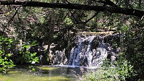 A waterfall in Wild Basin Wilderness Preserve | |
 | |
| Location | Central Texas, USA |
| Nearest city | Austin, Texas |
| Coordinates | 30°18′37″N 97°49′24″W / 30.31028°N 97.82333°WCoordinates: 30°18′37″N 97°49′24″W / 30.31028°N 97.82333°W |
| Established | 1974 |
| Governing body | Travis County Parks |

Wild Basin Wilderness Preserve consists of 227 acres (919,000 m2) of native Texas Hill Country habitat west of Austin, Texas in Westlake Hills. The preserve was founded in 1974. The preserve maintains 2.5 miles (4 km) of hiking trails.
Location[]
The entrance to the preserve is a mile north of Bee Caves Road along the east side of Loop 360. The hiking trails are open every day sunrise to sunset, usually this is in between the hours of 7am-7pm. The Wild Basin Creative Research Visitor Center is open M-F, 9am-4pm.
Bikes, pets, smoking and picnics are all prohibited within the preserve boundaries.
History[]
In 1974 Janet Poage, a Westlake Hills resident and prominent environmentalist, was instrumental in negotiating a developments rights agreement between the City of Austin, Travis County, and Westview Development creating the preserve.
Mrs. Poage along with Westview executive Beth Robertson, Mayor Carol McClellan and County Commissioner Ann Richards redrew the master plan of Westview's 1,300-acre Davenport Ranch residential development in order to set aside over 100 acres of the developer's land to protect the sensitive Hill Country environment including habitat for the endangered Black-Capped Vireo and Golden-Cheeked Warbler.
In the deal, Westview donated the land to Wild Basin and, in return, the City gave the developer the right to relocate 100 residential units originally planned on the preserve land to its adjacent property. This transaction was one of the first transfers of development rights in the Austin area and created one of the more important environmental laboratories on the Edwards Plateau.
External links[]
| Wikimedia Commons has media related to Wild Basin Wilderness Preserve. |
Slogan: Live Music Capital of the World | |||||||||||
| Attractions |
| ||||||||||
| History |
| ||||||||||
| Education |
| ||||||||||
| Government |
| ||||||||||
| Industry |
| ||||||||||
| Museums |
| ||||||||||
| Music |
| ||||||||||
| Neighborhoods |
| ||||||||||
| Parks and recreation |
| ||||||||||
| Transportation |
| ||||||||||
| Weirdness |
| ||||||||||
| Sports |
| ||||||||||
Austin–Round Rock–San Marcos | |||||
|---|---|---|---|---|---|
| Central city |
|  | |||
| Satellite cities |
| ||||
| Other communities |
| ||||
| Counties |
| ||||
| Parks and preserves |
| ||||
| Geography |
| ||||
| Bodies of water |
| ||||
| Transportation | |||||
Austin (capital) | ||
| Topics |
|  Seal of Texas |
| Society |
| |
| Regions |
| |
| Metropolitan areas |
| |
| Counties | ||
This article related to Austin, Texas is a stub. You can help Wikipedia by . |
This article related to a protected area in Texas is a stub. You can help Wikipedia by . |
- Nature reserves in Texas
- Nature centers in Texas
- Parks in Austin, Texas
- Protected areas established in 1974
- 1974 establishments in Texas
- Austin, Texas stubs
- Texas protected area stubs