Wooden Peak
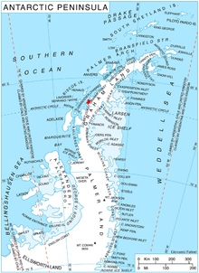
Wooden Peak (66°8′S 65°35′W / 66.133°S 65.583°WCoordinates: 66°8′S 65°35′W / 66.133°S 65.583°W) is a peak 2 nautical miles (3.7 km) southeast of on Stresher Peninsula on the west coast of Graham Land. Charted by the British Graham Land Expedition (BGLE) under Rymill, 1934–37. Named by the United Kingdom Antarctic Place-Names Committee (UK-APC) in 1959 for , Falkland Islands Dependencies Survey (FIDS) surveyor at Danco Island in 1956 and at Prospect Point in 1957. Wooden was also attached to the which worked in the area in 1957–58.
 WikiMiniAtlas
![]() This article incorporates public domain material from the United States Geological Survey document: "Wooden Peak". (content from the Geographic Names Information System)
This article incorporates public domain material from the United States Geological Survey document: "Wooden Peak". (content from the Geographic Names Information System) ![]()
This Graham Coast location article is a stub. You can help Wikipedia by . |
- Mountains of Graham Land
- Graham Coast
- Graham Coast geography stubs