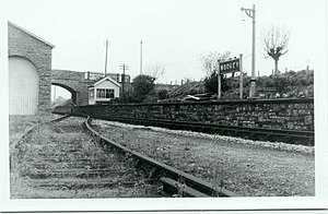
Wookey railway station
Wookey | |
|---|---|
 The railway station before closure | |
| Location | Wells, Mendip England |
| Coordinates | 51°12′51″N 2°40′22″W / 51.2142°N 2.6728°WCoordinates: 51°12′51″N 2°40′22″W / 51.2142°N 2.6728°W |
| Grid reference | ST531463 |
| Other information | |
| Status | Disused |
| History | |
| Original company | Bristol and Exeter Railway |
| Pre-grouping | Great Western Railway |
| Post-grouping | Great Western Railway |
| Key dates | |
| 1 August 1871 | Station opened |
| 9 September 1963 | Station closed |
| Site of Special Scientific Interest | |
 | |
| Location | Somerset |
|---|---|
| Grid reference | ST531464 |
| Interest | Geological |
| Area | 0.04 hectares (0.00040 km2; 0.00015 sq mi) |
| Notification | 1997 |
| Natural England website | |
Wookey railway station was a station on the Bristol and Exeter Railway's Cheddar Valley line in Somerset, England. The site is a 0.04 hectare geological Site of Special Scientific Interest between Wells and Wookey Hole
History[]
The station opened on 1 August 1871[1] about a year after the extension of the broad gauge line from Cheddar to Wells had been built. The line was converted to standard gauge in the mid-1870s and then linked up to the East Somerset Railway to provide through services from Yatton to Witham in 1878. All the railways involved were absorbed into the Great Western Railway in the 1870s.
The station was host to a GWR camp coach from 1935 to 1939.[2]
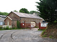
The Yatton to Witham line closed to passengers in 1963; Wookey station closed on 9 September 1963,[1] though goods traffic continued to the paper mills at Wookey until 1965. Wookey station had a small wooden building, unlike some of the other stations on the line which had impressive stone buildings. The site was cleared after closure.
| Preceding station | Disused railways | Following station | ||
|---|---|---|---|---|
| Lodge Hill Line and station closed |
Cheddar Valley Railway Great Western Railway |
Wells (Tucker Street) Line and station closed |
Site of Special Scientific Interest[]
It is listed in the Geological Conservation Review because of the exposure of a 3-metre (9.8 ft) thick sequence of Pleistocene-aged cryoturbated gravels which exhibit scour-and-fill structures in their lower part. A small, silty channel-infilling has yielded an assemblage of palynomorph spores dating from the last (Devensian) glacial period.[3]
See also[]
- Bruton Railway Cutting
References[]
| Wikimedia Commons has media related to Wookey railway station. |
- ^ a b Butt 1995, p. 255
- ^ McRae 1997, p. 31
- ^ English Nature citation sheet for the site (accessed 9 August 2006)
- Butt, R.V.J. (1995). The Directory of Railway Stations. Yeovil: Patrick Stephens Ltd. ISBN 1-85260-508-1. R508.
- McRae, Andrew (1997). British Railway Camping Coach Holidays: The 1930s & British Railways (London Midland Region). Vol. Scenes from the Past: 30 (Part One). Foxline. ISBN 1-870119-48-7.
- Oakley, Mike (2002). Somerset Railway Stations. Wimborne: Dovecote Press. p. 138.
- Disused railway stations in Somerset
- Former Great Western Railway stations
- Railway stations in Great Britain opened in 1871
- Railway stations in Great Britain closed in 1963
- Sites of Special Scientific Interest in Somerset
- Sites of Special Scientific Interest notified in 1997
- Geology of Somerset
- Railway cuttings in the United Kingdom
