Wuhle
This article does not cite any sources. (September 2020) |
show This article may be expanded with text translated from the corresponding article in German. (May 2018) Click [show] for important translation instructions. |
| Wuhle | |
|---|---|
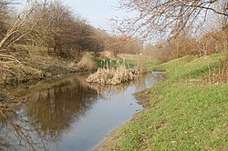 The Wuhle, as seen between Marzahn and Hellersdorf | |
 | |
| Location | |
| Country | Germany |
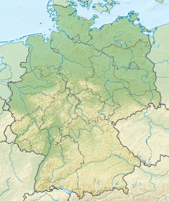
| State | Brandenburg |
| Physical characteristics | |
| Source | Forested area near Ahrensfelde |
| • coordinates | 52°35′46″N 13°34′13″E / 52.59611°N 13.57028°E |
| • elevation | 61 metres (200 ft) above Normalhöhennull (NHN) |
| Mouth | Spree |
• coordinates | 52°27′16″N 13°33′54″E / 52.45444°N 13.56500°ECoordinates: 52°27′16″N 13°33′54″E / 52.45444°N 13.56500°E |
• elevation | 30 metres (98 ft) above NHN |
| Length | 16.5 kilometres (10.3 mi) |
| Basin size | 118 square kilometres (46 sq mi) |
| Discharge | |
| • location | Honsfelder Bridge (5.8 km upstream the mouth) |
| • average | 1.05 m3/s (37 cu ft/s) |
| Basin features | |
| Progression | Spree→ Havel→ Elbe→ North Sea |
| Tributaries | |
| • left | |
| • right | |
| Waterbodies | , Wuhlebecken |

The Wuhle is a small right-bank tributary of the Spree. It originates in a ground moraine in Brandenburg near Ahrensfelde and flows through the Berlin boroughs of Marzahn-Hellersdorf and Treptow-Köpenick before joining the Spree.
It is the primary in- and outflow of the Wuhlebecken.
The Wuhle is depicted in the coat of arms of Marzahn-Hellersdorf.
See also[]
| Wikimedia Commons has media related to Wuhle. |
| Authority control |
|
|---|
Categories:
- Tributaries of the Spree
- Rivers of Brandenburg
- Rivers of Germany
- Brandenburg river stubs