Wyoming Basin physiographic province
| Wyoming Basin | |
|---|---|
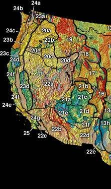 The Wyoming Basin (17) includes the Great Divide Basin. | |
| Location | Wyoming, United States |
| Coordinates | 42°31′24″N 109°39′09″W / 42.523422°N 109.652504°WCoordinates: 42°31′24″N 109°39′09″W / 42.523422°N 109.652504°W |

The Wyoming Basin physiographic province is a geographic area through which the Continental Divide of the Americas traverses. The province includes the [1] and Great Divide Basins, and is demarcated by the following:
- southwest: Uinta Mountains
- west: west side of Green River watershed
| External image | |
|---|---|
See also[]
References[]
- ^ "Select Area of Interest". [Wyoming Stratigraphy]. Wyoming State Geological Survey. Retrieved April 24, 2010. (Great Basin Divide, Washakie Basin)
This article about a location in Wyoming is a stub. You can help Wikipedia by . |
Categories:
- Physiographic provinces
- Geography of Carbon County, Wyoming
- Geography of Fremont County, Wyoming
- Geography of Sweetwater County, Wyoming
- Geography of Wyoming
- Wyoming geography stubs