Xylofagou
Xylofagou
Ξυλοφάγου | |
|---|---|
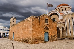 Agios Georgios church | |
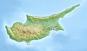 Xylofagou Location in Cyprus | |
| Coordinates: 34°58′30″N 33°51′6″E / 34.97500°N 33.85167°ECoordinates: 34°58′30″N 33°51′6″E / 34.97500°N 33.85167°E | |
| Country | |
| District | Larnaca District |
| Population (2011)[1] | |
| • Total | 6,231 |
| Time zone | UTC+2 (EET) |
| • Summer (DST) | UTC+3 (EEST) |
| Website | www |

Xylofagou (Greek: Ξυλοφάγου [locally [ksiloˈfau]]) is a sprawling Greek-Cypriot village situated close to the A3 Motorway between Dhekelia (Larnaca) and Paralimni / Agia Napa. It lies on the northern flank of a hill,[2] on the edge of an area of a group of several similar villages known as the "Kokkinochoria" ("the red villages"), known for growing vegetables, especially potatoes, in red soil.
Etymology[]
"Xylo" is the Greek word for "wood" and a "fagou" is an extremely popular barbecue-style spit roast used on holidays and high-days for cooking souvlakia. Most of the village lies in Larnaca District.
Landmarks[]
The town is home to a medieval Venetian watchtower.[3][4]
Near Xylofagou is the , where Christian soldiers sacrificed their lives in the 16th century to evade capture by the Ottomans.[5]
To commemorate the essential part the potato played in the Community's establishment and growth, a 16-foot-tall potato statue was erected in the village. The statue proved controversial, with some mocking its suggestive shape.[6] Community leader George Tasou responded to the comments by stating “I'm not bothered because it’s brought publicity to our village, and I’m hoping it will promote the Cyprus potato around the world”.[7]
Xylophagou Tower[]
| Xylophagou Tower | |
|---|---|
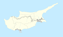 Location within Cyprus | |
| General information | |
| Architectural style | Medieval |
| Town or city | Xylofagou |
| Country | Dhekelia, Larnaca District |
| Coordinates | 34°57′01″N 33°51′21″E / 34.950326°N 33.855896°E |
Xylophagou Tower is a Venetian watchtower located in Pyrgos, south of Xylofagou.[8][9]
References[]
- ^ "C1. POPULATION ENUMERATED BY SEX, AGE, DISTRICT, MUNICIPALITY/COMMUNITY AND QUARTER (1.10.2011)", Population - Place of Residence, 2011, Statistical Service of the Republic of Cyprus, 2014-04-17, archived from the original on 2014-04-20, retrieved 2014-04-20
- ^ Bekker-Nielsen, Tonnes (2004). The Roads of Ancient Cyprus. Museum Tusculanum Press. p. 189. ISBN 978-87-7289-956-5. Retrieved 16 March 2012.
- ^ "The Venetian Watchtowers…". www.angloinfo.com. 20 March 2017. Retrieved 23 April 2018.
- ^ "Venetian Watchtowers Route (West Larnaka Region)". Larnaka Tourism Board. Retrieved 23 April 2018.
- ^ Bryant, Sue (27 January 2009). Frommer's Cyprus With Your Family: From the Best Family Beaches to Mountain Villages. John Wiley & Sons. p. 182. ISBN 978-0-470-72318-0. Retrieved 16 March 2012.
- ^ October 18, Jelisa Castrodale; 2021. "A Village in Cyprus Is Now Home to This 16-Foot-Tall Potato Statue". Food & Wine. Retrieved 2021-10-24.
{{cite web}}: CS1 maint: numeric names: authors list (link) - ^ Pitta, Antigoni. "'Viral' Big Potato garners attention at home and abroad | Cyprus Mail". cyprus-mail.com/. Retrieved 2021-10-24.
- ^ "The Venetian Watchtowers…". www.angloinfo.com. 20 March 2017. Retrieved 23 April 2018.
- ^ "Venetian Watchtowers Route (West Larnaka Region)". Larnaka Tourism Board. Retrieved 23 April 2018.

- Castles in Cyprus
- Buildings and structures in Larnaca
- Medieval architecture
- Castles in British Overseas Territories and Crown Dependencies
- Geography of Akrotiri and Dhekelia
- Communities in Larnaca District