Xylokastro
Xylokastro
Ξυλόκαστρο | |
|---|---|
 Partial view of Xylokastro beach (October 2019) | |
 Xylokastro Location within the regional unit 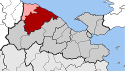 | |
| Coordinates: 38°4′N 22°38′E / 38.067°N 22.633°ECoordinates: 38°4′N 22°38′E / 38.067°N 22.633°E | |
| Country | Greece |
| Administrative region | Peloponnese |
| Regional unit | Corinthia |
| Municipality | Xylokastro-Evrostina |
| • Municipal unit | 310.3 km2 (119.8 sq mi) |
| Elevation | 3 m (10 ft) |
| Population (2011)[1] | |
| • Municipal unit | 13,277 |
| • Municipal unit density | 43/km2 (110/sq mi) |
| Community | |
| • Population | 5,715 (2011) |
| Time zone | UTC+2 (EET) |
| • Summer (DST) | UTC+3 (EEST) |
| Postal code | 204 00 |
| Area code(s) | 27430 |
| Vehicle registration | ΚΡ |
| Website | http://www.xylokastro-evrostini.gov.gr/ |

Xylokastro (Greek: Ξυλόκαστρο) is a seaside town or village and a former municipality in Corinthia in the Peloponnese, Greece. Since the 2011 local government reform it is part of the municipality Xylokastro-Evrostina, of which it is a unit or component.[2] The municipal unit has an area of 310.252 km2.[3] In 2011 its population was 5,715 for the town and 13,277 for the municipal unit.
Geographic features include a long 2 km beach and semi-arid forest on varied terrain, scattered with early churches and evidence of early settlements and religious sites. It has narrowly separated upper and lower coastal roads and forms a medium-sized touristic village on the Gulf of Corinth.
Subdivisions[]
The municipal unit Xylokastro is subdivided into the following communities (2011 population and constituent villages in brackets):
- (104, Ano Trikala, Zireia)
- (144)
- Geliniatika (431, Geliniatika, Spartinaaika)
- (903, Kamari, Kariotika)
- (597, Karya, Kariotika)
- (442, Kato Loutro, Ano Loutro)
- (254)
- (75)
- (74, Lagkadaiika, Amfithea)
- Manna (476)
- (913)
- (73)
- (76)
- Panariti (349)
- Pellini (82)
- (669, Ano Pitsa, Kato Pitsa)
- (194)
- (429, Riza, Valtos, Georgantaiika, Sigeritsa, Chartsianika)
- (80)
- (147)
- Sykia (492)
- Thalero (162)
- (73)
- (83)
- Xylokastro (5,715, Xylokastro, Mertikaiika)
- (240)
Population[]
| Year | Town population | Municipality population |
|---|---|---|
| 1700 | 65 | - |
| 1981 | 5,188 | - |
| 1991 | 5,821 | 16,802 |
| 2001 | 5,618 | 15,273 |
| 2011 | 5,715 | 13,277 |
Geography[]
Xylokastro is situated on the coast of the Gulf of Corinth, 30 km northwest of Corinth, near the mouth of the river . Apart from the narrow strip of land along the coast, where the town Xylokastro lies, the municipal unit is mountainous. The Greek National Road 8a (Corinth - Patras) passes through the town.
History[]
The town took its name from a wooden castle (Greek: ξύλινο κάστρο), probably built in the 13th century.[4] It was also known as Solo Castro.[5] The village Stylia was known as Viladusa by the Venetians in the 18th century.[6]
People[]
- Vlassis Bonatsos (1949 - October 14, 2004 in Athens, Greece), a Greek actor
- Panagis Tsaldaris (1932 - November 3, 1933 in Athens, Greece,
- (1922 - September 17, 1922 14 November in Athens. Greece former prime minister
References[]
- ^ a b "Απογραφή Πληθυσμού - Κατοικιών 2011. ΜΟΝΙΜΟΣ Πληθυσμός" (in Greek). Hellenic Statistical Authority.
- ^ "ΦΕΚ B 1292/2010, Kallikratis reform municipalities" (in Greek). Government Gazette.
- ^ "Population & housing census 2001 (incl. area and average elevation)" (PDF) (in Greek). National Statistical Service of Greece.
- ^ www.xylokastro-evrostini.gov.gr
- ^ De Wit, 1680
- ^ www.xylokastro-evrostini.gov.gr
External links[]
- Official website - Municipality of Xylokastro-Evrostina (in Greek)
- GTP - Xylokastro
- GTP - Municipality of Xylokastro
See also[]
- Dissolved municipalities and communes in Greece
- Populated places in Corinthia
- Xylokastro