Ymer Island
Native name: Ymer Ø | |
|---|---|
 View of Ymer Island with ice floes in the foreground. | |
 Map of Ymer Island | |
 Ymer Island Location of Ymer Island in Greenland | |
| Etymology | Named after the mythical Norse giant Ymir |
| Geography | |
| Location | Greenland Sea |
| Coordinates | 73°09′N 24°20′W / 73.150°N 24.333°WCoordinates: 73°09′N 24°20′W / 73.150°N 24.333°W |
| Area | 2,437 km2 (941 sq mi) |
| Area rank | 5th largest in Greenland 184th largest in world |
| Length | 91 km (56.5 mi) |
| Width | 36 km (22.4 mi) |
| Highest elevation | 1,900 m (6200 ft)[1] |
| Highest point | |
| Administration | |
| Unincorporated area | NE Greenland National Park |
| Demographics | |
| Population | 0 (2021) |
| Pop. density | 0/km2 (0/sq mi) |
| Ethnic groups | none |

Ymer Island (Danish: Ymer Ø) is an island in northeastern Greenland. The island is a part of Northeast Greenland National Park.
Ymer Island is named after the giant Ymir, the forefather of the Jotuns in Norse mythology.
Geography[]
The island lies on the southern side of the entrance of Kaiser Franz Joseph Fjord, with the Antarctic Sound separating it from the Suess Land Peninsula. Ymer Island's northern half forms a peninsula named Gunnar Anderson Land having its narrow isthmus in the west. The fjord between the two halves of the island is named Dusen Fjord.
Ymer Island has an area of 2,437 km2.[2] It is mountainous; , its highest peak, reaches a height of 1900 m. Celsius Bjerg is located at the southeastern end of the island.[3]
The conspicuous Devil's Castle (Teufelsschloss) is located on the other side of Kaiser Franz Joseph Fjord, off the southern shore of , the NW extremity of Ymer Island.[4]
 Mountaintops in Ymer Island |
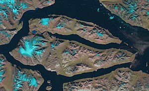 Landsat satellite image |
See also[]
References[]
- ^ Angelin Bjerg - Peakbagger.com
- ^ UNEP
- ^ Celsius Bjerg - Mapcarta
- ^ Prostar Sailing Directions 2005 Greenland and Iceland Enroute, p. 120
External links[]
 Media related to Ymer Island at Wikimedia Commons
| Authority control |
|
|---|
This Greenland location article is a stub. You can help Wikipedia by . |
- Uninhabited islands of Greenland
- Greenland geography stubs