Yokohama Bay Bridge
This article needs additional citations for verification. (December 2009) |
Yokohama Bay Bridge | |
|---|---|
 | |
| Coordinates | 35°27′18″N 139°40′27″E / 35.4551°N 139.6742°ECoordinates: 35°27′18″N 139°40′27″E / 35.4551°N 139.6742°E |
| Carries | 3 lanes of Bayshore Route (upper), 1 lane of National Route 357 (lower), prohibited to pedestrians or bicycles |
| Crosses | Port of Yokohama |
| Locale | between Honmoku and Daikoku Pier, Naka-ku, Yokohama, Kanagawa |
| Characteristics | |
| Design | Cable-stayed |
| Total length | 860 metres (2,820 ft)[1] |
| Width | 40.2 metres (132 ft) |
| Height | 172 metres (564 ft) |
| Longest span | 460 m (1,509.2 ft)[1] |
| Clearance above | Higher truck loads possible |
| Clearance below | 55 metres (180 ft) |
| History | |
| Opened | September 27, 1989 |
| Location | |
 | |

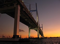
Yokohama Bay Bridge at dawn
The Yokohama Bay Bridge (横浜ベイブリッジ, Yokohama Bei Buridji) is an 860 metres (2,820 ft) cable stayed bridge in Yokohama, Japan. Opened September 27, 1989, it crosses Tokyo Bay with a span of 460 metres (1,510 feet). The toll is ¥600. The bridge is part of the Bayshore Route of the Shuto Expressway.
Notes[]
- ^ Jump up to: a b "Yokohama Bay Bridge". Ministry of Land, Infrastructure, Transportation and Tourism (MLIT). Retrieved 2010-07-10.
External links[]
 Media related to Yokohama Bay Bridge at Wikimedia Commons
This article about a bridge in Japan is a stub. You can help Wikipedia by . |
This Kanagawa Prefecture location article is a stub. You can help Wikipedia by . |
Categories:
- Bridges completed in 1989
- Cable-stayed bridges in Japan
- Buildings and structures in Yokohama
- Toll bridges in Japan
- 1989 establishments in Japan
- Transport in Yokohama
- Japan bridge (structure) stubs
- Kanagawa geography stubs