Ytter-Vikna
 | |
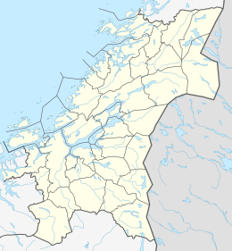 Ytter-Vikna Location of the island | |
| Geography | |
|---|---|
| Location | Trøndelag, Norway |
| Coordinates | 64°54′41″N 10°52′56″E / 64.9113°N 10.8821°ECoordinates: 64°54′41″N 10°52′56″E / 64.9113°N 10.8821°E |
| Area | 82 km2 (32 sq mi) |
| Length | 25 km (15.5 mi) |
| Width | 7 km (4.3 mi) |
| Highest elevation | 173 m (568 ft) |
| Highest point | Vattafjellet |
| Administration | |
Norway | |
| County | Trøndelag |
| Municipality | Nærøysund |


Ytter-Vikna (sometimes Ytre Vikna) is one of the three major islands in the municipality of Nærøysund in Trøndelag county, Norway. It is located in the western part of Vikna. crosses the 82-square-kilometre (32 sq mi) island. The villages of Austafjord and Valøya are located on this island.[1]
See also[]
References[]
- ^ Rosvold, Knut A., ed. (2017-12-25). "Vikna". Store norske leksikon (in Norwegian). Kunnskapsforlaget. Retrieved 2018-05-05.
This Trøndelag location article is a stub. You can help Wikipedia by . |
Categories:
- Islands of Trøndelag
- Nærøysund
- Vikna
- Trøndelag geography stubs