Yunfu
Coordinates: 22°54′55″N 112°02′40″E / 22.9152°N 112.0445°E

Yunfu
云浮市 | |
|---|---|
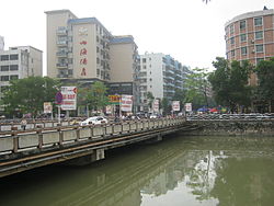 Yunfu in 2013. Bridge over Nanshan river. | |
 | |
 Location of Yunfu in Guangdong | |
 Yunfu Location in China | |
| Coordinates (Yunfu administrative service center (云浮市人民政府行政服务中心)): 22°56′02″N 112°02′35″E / 22.934°N 112.043°E | |
| Country | People's Republic of China |
| Province | Guangdong |
| County-level divisions | 5 |
| Township divisions | 112 |
| Incorporated as Linyun County | 111 CE |
| Yunfu County formed | May 1914 |
| Promoted to prefecture-level city | April 5, 1994 |
| City seat | Yuncheng District |
| Government | |
| Area | |
| • Total | 7,813.4 km2 (3,016.8 sq mi) |
| Elevation | 133 m (436 ft) |
| Population (2010 census) | |
| • Total | 2,367,154 |
| • Density | 300/km2 (780/sq mi) |
| Time zone | China Standard |
| Area code(s) | 766 |
| ISO 3166 code | CN-GD-53 |
| License Plate | 粤W |
| Major Nationalities | Han |
| Website | Official website |
| Yunfu | |||
|---|---|---|---|
 "Yunfu", as written in Chinese calligraphy | |||
| Simplified Chinese | 云浮 | ||
| Traditional Chinese | 雲浮 | ||
| Hanyu Pinyin | Yúnfú | ||
| Cantonese Yale | Wàhnfàuh | ||
| Postal | Wanfow | ||
| Literal meaning | Cloud Drift | ||
| |||
Yunfu (simplified Chinese: 云浮; traditional Chinese: 雲浮; pinyin: Yúnfú), formerly romanized as Wanfow, and historically known as Dong'an (simplified Chinese: 东安; traditional Chinese: 東安; pinyin: Dōng'ān), which was formerly romanized as Tong On, from 1578-1913, is a prefecture-level city in western Guangdong province, People's Republic of China. It borders Zhaoqing to the north, Foshan to the east, Jiangmen to the southeast, Yangjiang to the south, Maoming to the southwest, and the autonomous region of Guangxi to the west. The city spans an area of 7,786.64 square kilometres (3,006.44 sq mi), and has a population of 2,383,400 according to a 2021 publication by the city government.[1]
History[]
The area of present-day Yunfu belonged to the Baiyue prior to the advent of the Qin dynasty, when much of Yunfu came under the jurisdiction of Guilin Commandery, while some of the area belonged to Nanhai Commandery.[2] During portions of the Han dynasty, the area belonged to the kingdom of Nanyue.[2] Following the fall of the Nanyue in 111 CE, the area of present-day Xinxing County was incorporated into the Western Han dynasty as Linyun County (Chinese: 临允县).[2]
Jin dynasty[]
Under the Jin dynasty, in 280 CE, the area of present-day Yunan County was organized as Duluo County (Chinese: 都罗县).[2] In 349 CE, the area of present-day Yunan County was reorganized as Jinhua County (Chinese: 晋化县).[2] Two years later, the area of present-day Xinxing County was reorganized as , which governed three counties: Xinxing County (Chinese: 新兴县), Nanxing County (Chinese: 南兴县), and Dandie County (Chinese: 单牒县).[2] During the final years of the Jin dynasty, from 416 CE to 420 CE, Longxiang County (Chinese: 龙乡县) and Furuan County (Chinese: 夫阮县) were established in present-day Luoding.[2]
Northern and Southern dynasties[]
During the Northern and Southern dynasties period, the area of present-day Yunfu was governed by the Southern Song dynasty from 420 CE to 479 CE, then by the Southern Qi dynasty from 479 CE to 502 CE, and finally by the Liang dynasty from 502 CE to 557 CE.[2] From 557 CE to 589 CE, the area was ruled by the Chen dynasty.[2]
Later dynasties[]
The area was incorporated into the Tang dynasty in 618 CE.,[2] Following the Five Dynasties and Ten Kingdoms period, the area was conquered by the Song dynasty (not to be confused with the aforementioned Song dynasty which ruled portions of Southern China during the 5th century CE).[2]
Republic of China[]
Shortly after the creation of the Republic of China in 1912, republican officials reorganized the area multiple times.[2] In January 1914, Xining County was renamed to Yunan County (which it is still called today), and in May 1914 Dong'an County was renamed to Yunfu County.[2]
People's Republic of China[]
Yunfu was promoted to a prefecture-level city on April 5, 1994.[2]
In September 2014, Yun'an was promoted from a county to a district.[2]
Geography[]
67.39% of Yunfu's area is forested.[1] The Xi River runs through Yunfu.[1]
Climate[]
Yunfu is considered sub-tropical and enjoys fine weather year-round, characterized by mild air temperatures, plentiful rainfall and sunshine, with an annual average temperature of 22 °C, annual average rainfall of 1,580mm and annual average sunshine hours of 1,418. The time-space distribution of rainfall is uneven in a year. It is overcast and dry in spring, hot and rainy in the summer, cool in autumn, and dry and sunny in winter.
| showClimate data for Yunfu (1981−2010) |
|---|
Administration[]
The prefecture-level city of Yunfu administers 5 county-level divisions, including 2 district, 1 county-level city and 2 counties.
| Map | |||||
|---|---|---|---|---|---|
| Name | Simplified Chinese | Hanyu Pinyin | Population (2010 census) |
Area (km2) |
Density (/km2) |
| Yuncheng District | 云城区 | Yúnchéng Qū | 314,188 | 762 | 412 |
| Yun'an District | 云安区 | Yún'ān Qū | 269,736 | 1,231 | 219 |
| Xinxing County | 新兴县 | Xīnxīng Xiàn | 428,410 | 1,520 | 282 |
| Yunan County | 郁南县 | Yùnán Xiàn | 388,727 | 1,966 | 198 |
| Luoding | 罗定市 | Luódìng Shì | 959,067 | 2,300 | 417 |

Demographics[]
According to the city government, 420,000 overseas Chinese hail from Yunfu.[1]
Ethnicity[]
Yunfu is home to 39 ethnic minorities, which comprise a total population of 14,038.[3] The largest ethnic minorities in Yunfu are the Zhuang, Yao, Dong, and the Miao.[3] While many of Yunfu's ethnic minorities recently moved to the city due to marriage and work, there are large concentrations of indigenous minorities in two villages in Yunfu: Hejiang Village (Chinese: 合江村) in , Luoding, and Dalin Village (Chinese: 大林村) in , Yunan County.[3]
Language[]
Several languages are commonly spoken in Yunfu, including the Yunfu Dialect (Chinese: 云浮白话) of Cantonese, Hakka, Min-nan, and the (Chinese: 㑷古话).[3] The Yunfu Dialect is the most commonly spoken in Yunfu, followed by Hakka.[3] The city's Min-nan speakers are concentrated in certain areas, including the towns of and in Yunan County, Zhaitang Village (Chinese: 寨塘村) in the town of , Yun'an District, and the towns of , , , and