Zaghouan
This article includes a list of general references, but it remains largely unverified because it lacks sufficient corresponding inline citations. (December 2019) |
Zaghouan
زغوان | |
|---|---|
 Zaghouan Governorate | |
 Zaghouan Location in Tunisia | |
| Coordinates: 36°24′N 10°09′E / 36.400°N 10.150°E | |
| Country | |
| Governorate | Zaghouan Governorate |
| Population (2014) | |
| • Total | 20,837 |
| Time zone | UTC+1 (CET) |

Zaghwan (or Zaghouan; Arabic: زغوان ![]() Zaġwān) is a town in the northern half of Tunisia.
Zaġwān) is a town in the northern half of Tunisia.
Situated on a low ridge of the , the town has a mild climate and presents a green aspect. Cold water from here was taken by the Zaghouan Aqueduct to Carthage. The town is famous for its roses, originally cultivated by Muslim refugees from Spain in the seventeenth century. The town is located around 60 km due south of Tunis and around 50 km inland (west) from the Gulf of Hammamet and has an estimated population of around 20,837 (2014). It is the capital of the Zaghouan Governorate.
On the mountain south of the city is the Roman Water Temple Djebel Zaghouan (Temple de Eaux), source of an aqueduct which used to take water to the city of Carthage over 100 km away. The ruins here are illustrated in Fisher's Drawing Room Scrap Book, 1840, as 'Temple and Fountain of Zagwhan', the subject of a poem by Letitia Elizabeth Landon.
| Wikisource has original text related to this article: |
Ecclesiastical history[]
Zagwan is the presumed site of the Ancient city of Zica, which was among the many of sufficient importance in the Roman province of Africa Proconsularis to become a suffragan diocese of the Metropolitan of Carthage, in the papal sway, yet was to fade completely, probably at the seventh century advent of Islam.
Its historically documented bishops were :
- Donatist schismatic Donatus attended the Council of Carthage in 411, where his heresy was condemned as such by the Catholic bishops, among whom Zica had no counterpart
- Vincentius intervened at the Council of Carthage in 484 called by king Huneric of the Vandal Kingdom, and was afterwards exiled like most Catholic bishops.
Climate[]
| hideClimate data for Zaghouan (1981–2010, extremes 1953–2017) | |||||||||||||
|---|---|---|---|---|---|---|---|---|---|---|---|---|---|
| Month | Jan | Feb | Mar | Apr | May | Jun | Jul | Aug | Sep | Oct | Nov | Dec | Year |
| Record high °C (°F) | 27.5 (81.5) |
31.5 (88.7) |
35.6 (96.1) |
39.9 (103.8) |
43.3 (109.9) |
47.6 (117.7) |
48.0 (118.4) |
46.5 (115.7) |
42.8 (109.0) |
41.0 (105.8) |
30.5 (86.9) |
31.5 (88.7) |
48.0 (118.4) |
| Average high °C (°F) | 15.5 (59.9) |
16.2 (61.2) |
19.0 (66.2) |
21.9 (71.4) |
27.0 (80.6) |
32.2 (90.0) |
35.6 (96.1) |
35.9 (96.6) |
31.0 (87.8) |
26.5 (79.7) |
20.5 (68.9) |
16.5 (61.7) |
24.8 (76.7) |
| Daily mean °C (°F) | 10.3 (50.5) |
10.6 (51.1) |
12.8 (55.0) |
15.2 (59.4) |
19.9 (67.8) |
24.4 (75.9) |
27.2 (81.0) |
27.7 (81.9) |
23.9 (75.0) |
20.2 (68.4) |
15.2 (59.4) |
11.6 (52.9) |
18.3 (64.9) |
| Average low °C (°F) | 5.5 (41.9) |
5.4 (41.7) |
7.0 (44.6) |
9.3 (48.7) |
13.0 (55.4) |
16.7 (62.1) |
19.3 (66.7) |
20.2 (68.4) |
18.2 (64.8) |
14.8 (58.6) |
10.1 (50.2) |
6.7 (44.1) |
12.2 (53.9) |
| Record low °C (°F) | −3.0 (26.6) |
−2.0 (28.4) |
−2.2 (28.0) |
0.4 (32.7) |
3.0 (37.4) |
6.5 (43.7) |
9.5 (49.1) |
10.4 (50.7) |
7.3 (45.1) |
5.0 (41.0) |
0.1 (32.2) |
−3.0 (26.6) |
0.3 (32.5) |
| Average precipitation mm (inches) | 78.8 (3.10) |
40.2 (1.58) |
43.9 (1.73) |
42.9 (1.69) |
26.8 (1.06) |
10.3 (0.41) |
3.1 (0.12) |
12.6 (0.50) |
50.5 (1.99) |
49.7 (1.96) |
49.5 (1.95) |
57.0 (2.24) |
465.3 (18.33) |
| Average precipitation days (≥ 1.0 mm) | 7.2 | 7.3 | 6.7 | 5.6 | 3.9 | 1.9 | 0.5 | 1.6 | 4.1 | 5.8 | 5.6 | 6.5 | 56.7 |
| Average relative humidity (%) | 75.0 | 75.0 | 71.8 | 66.9 | 62.9 | 56.4 | 50.8 | 53.4 | 62.8 | 67.6 | 70.8 | 72.7 | 65.5 |
| Mean monthly sunshine hours | 154.4 | 138.3 | 180.4 | 229.8 | 283.9 | 302.2 | 343.6 | 339.8 | 246.6 | 193.6 | 176.1 | 145.3 | 2,734 |
| Source: Institut National de la Météorologie (precipitation days/humidity/sun 1961–1990)[1][2][3][note 1] | |||||||||||||
Gallery[]

Postcard of Zaghouan in 1900
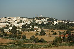
Zaghouan in Tunisia

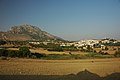
Tunisie Parc on Djebel Zaghouan


See also[]
- List of Catholic dioceses in Tunisia
Notes[]
References[]
- ^ "Les normales climatiques en Tunisie entre 1981 2010" (in French). Ministère du Transport. Archived from the original on 19 December 2019. Retrieved 26 December 2019.
- ^ "Données normales climatiques 1961-1990" (in French). Ministère du Transport. Archived from the original on 21 December 2019. Retrieved 26 December 2019.
- ^ "Les extrêmes climatiques en Tunisie" (in French). Ministère du Transport. Archived from the original on 21 December 2019. Retrieved 26 December 2019.
- ^ "Réseau des stations météorologiques synoptiques de la Tunisie" (in French). Ministère du Transport. Retrieved 26 December 2019.
Sources and external links[]
- Bibliography - Zica bishopric
- J. Mesnage, L'Afrique chrétienne, Paris 1912, pp. 237–238
| Wikimedia Commons has media related to Zaghouan. |
Coordinates: 36°24′N 10°09′E / 36.400°N 10.150°E
| show Authority control |
|---|
This Tunisia location article is a stub. You can help Wikipedia by . |
- Populated places in Zaghouan Governorate
- Communes of Tunisia
- Catholic titular sees in Africa
- Tunisia geography stubs