Zagora, Morocco
Zagora
Zagura / ⵣⴰⴳⵓⵔⴰ زاكورة | |
|---|---|
    | |
 Zagora Location in Morocco | |
| Coordinates: 30°19′50″N 5°50′17″W / 30.33056°N 5.83806°WCoordinates: 30°19′50″N 5°50′17″W / 30.33056°N 5.83806°W | |
| Country | |
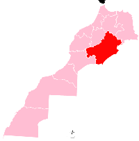
| Region | Drâa-Tafilalet |
| Province | Zagora |
| Population (2004) | |
| • Total | 34,851 |
| Time zone | UTC+0 (WET) |
| • Summer (DST) | UTC+1 (WEST) |


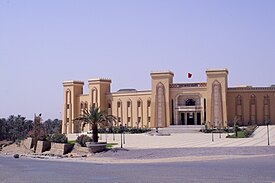
Zagora (Berber language: Tazagurt, Arabic: زاكورة) is a town located in the Draa River valley in the Moroccan region of Drâa-Tafilalet.
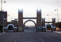
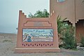
It is flanked by the mountain Zagora from which the town got its name. Originally it was called 'Tazagourt' (ⵜⴰⵣⴰⴳⵓⵔⵜ) the singular of plural 'Tizigirt' (ⵜⵉⵣⵉⴳⵉⵔⵜ), Berber for 'twinpeaks', referring to the fortress of the Murabitun, or Almoravid, people. In old European maps the mountain Zagora is already indicated but the town itself was only built in the 20th century. On the base of the Zagora mountain the remains of an Almoravid fortress can still be seen.[1] The exact location of the former Almoravid mosque is still a matter of dispute. Each year the moussem (festival) of the Sufi saint moulay Abdelkader Jilali is celebrated at Zagora. Languages spoken in the city include Moroccan Arabic, Tachelhit and Tamazight. A sign at the town border states "Tombouctou 52 days", the supposed time it takes to get to Timbuktu, Mali on foot or camel. The original sign has been replaced by a mural painting.[2]
History[]
This section needs expansion. You can help by . (June 2021) |
Climate[]
Zagora has a hot desert climate (Köppen climate classification BWh).
| hideClimate data for Zagora | |||||||||||||
|---|---|---|---|---|---|---|---|---|---|---|---|---|---|
| Month | Jan | Feb | Mar | Apr | May | Jun | Jul | Aug | Sep | Oct | Nov | Dec | Year |
| Average high °C (°F) | 20.3 (68.5) |
22.4 (72.3) |
26.0 (78.8) |
30.7 (87.3) |
35.5 (95.9) |
40.8 (105.4) |
44.9 (112.8) |
43.5 (110.3) |
36.7 (98.1) |
30.8 (87.4) |
25.2 (77.4) |
20.4 (68.7) |
31.4 (88.6) |
| Average low °C (°F) | 3.8 (38.8) |
5.9 (42.6) |
9.6 (49.3) |
13.1 (55.6) |
17.1 (62.8) |
21.4 (70.5) |
25.1 (77.2) |
25.0 (77.0) |
19.9 (67.8) |
15.1 (59.2) |
10.6 (51.1) |
5.5 (41.9) |
14.3 (57.8) |
| Average precipitation mm (inches) | 4 (0.2) |
3 (0.1) |
5 (0.2) |
1 (0.0) |
2 (0.1) |
1 (0.0) |
1 (0.0) |
3 (0.1) |
6 (0.2) |
13 (0.5) |
15 (0.6) |
7 (0.3) |
61 (2.4) |
| Source: Climate-data.org | |||||||||||||
Culture[]
Zagora is also noted for international events such as the Zagora Marathon and the Nomads Festival in M'Hamid.
Local institutions[]
The weekly outdoor market (souk) is held on Sunday in the city center.[3]
Features[]


Military castle


References[]
- ^ Allain (Ch) & Meunie (J.), "La forteresse almoravide de Zagora", Hespéris, 1956, vol. xliii, fasc. 2, pp. 305–325.
- ^ blog.travel-exploration.com Travel-blog with picture of the old and new sign. Sitat: The town has recently had a new “52 Days to Timbuktu “ sign painted and posted however the old one still remains.
- ^ List of weekly open-air markets in the province of Zagora
External links[]
| show Authority control |
|---|
- Populated places in Zagora Province
- Provincial capitals in Morocco
- Zagora Province