Zamfara River
This article needs additional citations for verification. (September 2014) |
| Zamfara River | |
|---|---|
 Sokoto river basin, Zamfara river to the south | |
 Major rivers of Nigeria | |
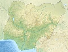 Location of mouth | |
| Location | |
| Country | Nigeria |
| State | Zamfara |
| Physical characteristics | |
| Mouth | Sokoto River |
• coordinates | 11°59′46″N 4°05′25″E / 11.9960°N 4.0904°ECoordinates: 11°59′46″N 4°05′25″E / 11.9960°N 4.0904°E |
| Length | 250 km (160 mi) |
| Basin features | |
| River system | Sokoto River |

The Zamfara River is a river in the northern part of Nigeria. Originating in Zamfara State, it runs some 250 kilometres (160 mi) west into Kebbi State where it joins with the Sokoto River some 50 kilometres (31 mi) southwest of Birnin Kebbi.
At its highest point the Zamfara River flows through an area that is 188 metres (617 ft) above sea level. There are various names for the Zamfara in different regions that it flows through. Some of the most common ones include Gulbi Gindi, Gulbi Zamfara, River Zamfara, and River Gindi. The river is at latitude 12°2'2.22" and longitude: 4°2'22.85"[1]

References[]
- ^ "River Zamfara". Retrieved 23 October 2013.
This Zamfara State, Nigeria location article is a stub. You can help Wikipedia by . |
This Kebbi State, Nigeria location article is a stub. You can help Wikipedia by . |
- Rivers of Nigeria
- North West Nigeria geography stubs
- Africa river stubs
- Nigeria geography stubs