Zeithain
Zeithain | |
|---|---|
 Coat of arms | |
show Location of Zeithain within Meißen district | |
 Zeithain | |
| Coordinates: 51°20′N 13°21′E / 51.333°N 13.350°ECoordinates: 51°20′N 13°21′E / 51.333°N 13.350°E | |
| Country | Germany |
| State | Saxony |
| District | Meißen |
| Subdivisions | 11 |
| Government | |
| • Mayor (2021–28) | Mirko Marcus Pollmer[1] |
| Area | |
| • Total | 81.49 km2 (31.46 sq mi) |
| Elevation | 98 m (322 ft) |
| Population (2020-12-31)[2] | |
| • Total | 5,509 |
| • Density | 68/km2 (180/sq mi) |
| Time zone | UTC+01:00 (CET) |
| • Summer (DST) | UTC+02:00 (CEST) |
| Postal codes | 01619 |
| Dialling codes | 03525 |
| Vehicle registration | MEI, GRH, RG, RIE |
| Website | www.zeithain.de |


Zeithain is a municipality in the district of Meißen, in Saxony, Germany.
Historically, it is known for the Zeithain Encampment (Zeithainer Zeltlager or Zeithainer Lustlager), which was a huge agglomeration of tents and troops, involving the whole 27,000-men-strong army of August the Strong. This event took place from 1 to 26 June 1730.[3]
During World War II a large prisoner-of-war camp, Stalag IV-B/H, was located in Zeithain. A memorial and museum commemorate it.[4]
Municipality subdivisions[]
Zeithain includes the following subdivisions:
- Cottewitz
- Gohlis
- Jacobsthal
- Kreinitz
- Lorenzkirch
- Moritz
- Neudorf
- Promnitz
- Röderau-Bobersen
- Zschepa
Mayor[]
In 2021 Mirko Marcus Pollmer was elected mayor.[1]
Gallery[]

Zeithain Encampment in 1730
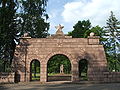
Memorial Ehrenhain, Zeithain

Memorial stone April 1945 in Lorenzkirch

Ruin of the Holländermühle in Lorenzkirch, Zeithain


Twin towns[]
 Teningen, Germany
References[]
- ^ Jump up to: a b Wahlergebnisse 2021, Freistaat Sachsen, accessed 10 July 2021.
- ^ "Bevölkerung des Freistaates Sachsen nach Gemeinden am 31. Dezember 2020". Statistisches Landesamt des Freistaates Sachsen (in German). June 2021.
- ^ Holger Schuckelt: The Turkish Chamber: Oriental Splendour in the Dresden Armoury, Munich: Deutscher Kunstverlag, 2010, ISBN 978-3-422-06914-5, p. 112
- ^ Memorial and History of Zeithain camp
| show Towns and municipalities in Meissen (district) |
|---|
| show Authority control |
|---|
This Meissen location article is a stub. You can help Wikipedia by . |
- Municipalities in Saxony
- Meissen (district)
- Bezirk Dresden
- Saxony geography stubs