Zellertal (region)
| Zellertal | |
|---|---|
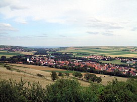 View of Albisheim in the Zellertal | |
| Floor elevation | 185DE-NHN |
| Length | 12 |
| Geography | |
| Location | Rhineland-Palatinate, Germany |
| Coordinates | 49°38′44″N 8°7′25″E / ���49.64556°N 8.12361°ECoordinates: 49°38′44″N 8°7′25″E / 49.64556°N 8.12361°E |
| Mountain range | North Palatine Uplands |
| Rivers | Pfrimm with (left) and () |

The Zellertal is a valley region in the east of the North Palatine Uplands in the German state of Rhineland-Palatinate. Its western part belongs to Palatine Donnersbergkreis, its eastern part to Rhenish Hessian Alzey-Worms. The valley is named after the old municipality of , which became part of the new Zellertal municipality in 1976.
Geography[]
The Zellertal is a trough-shaped valley with relatively gently sides and is bounded in the north and south by two chains of low hills that are under 300 m.[1] The distance between the two hill ridges is 2 to 3 kilometres. In between, the valley stretches from west to east, sheltered from north winds. Flowing through the valley in this direction is the Pfrimm, a left ban tributary of the Rhine which is just under 43 kilometres long.
The exit to the valley in the east lies at a height of about 135 m in Rhenish Hesse in the collective municipality of Monsheim, to which belong the first 3 valley parishes of Monsheim, Wachenheim and Mölsheim as we travel upriver. To the west, on the Palatine side, follow the next three parishes of Zellertal (, Zell and ) and the parishes of Einselthum, Albisheim and Marnheim. The Zellertal ends here after 12 km at 185 m.
Sights[]
The symbol of the valley is the 15-metre-high Zellertal Memorial which can be seen from a long way off. The Expressionist New Gothic monument was built in 1928 as a war memorial in honour of the fallen of the First World War. It is located on an exposed viewing point near the K 64 which runs along the hillside between Zell and Mölsheim.[2] The Baroque pilgrimage church of Zell is dedicated to , who was elevated to the sainthood in the Bishopric of Speyer. Other sights are described in the individual village articles.
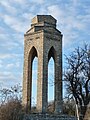
Zellertal Memorial
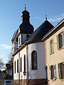
Pilgrimage church of Zell - exterior
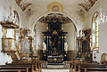
Pilgrimage church of Zell - interior
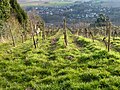
Vineyards in the Zellertal


Economy and infrastructure[]
Viticulture[]
The Zellertal is the northern end of the Palatine wine region; while the Rhenish Hesse wine area begins at the eastern end of the valley. The Zellertal wine region covers a larger area that the valley itself, has 15 vineyards with a lagen with a vine area of 550 hectares.[3] The wine region includes other wine-growing municipalities such as Bischheim, Rittersheim and Gauersheim, which are in the side valley of the , a left bank tributary of the Pfrimm.[4]
Transport[]
The Zellertal is accessed by the (Worms–Marnheim), which runs between the A 63 (Kaiserslautern–Mainz) in the west and the (Neustadt an der Weinstraße–Alzey) in the east. On the western edge of Wachenheim, the B 47 has been extended to the west as a ring road.
On Sundays and holidays from the beginning of May to the end of October the Zeller Valley Railway runs from Monsheim via to Kaiserslautern.
External links[]
- Location of the Zellertal at: Map service of the Landscape Information System of the Rhineland-Palatinate Nature Conservation Office (Naturschutzverwaltung Rheinland-Pfalz)
References[]
- ^ Map service of the Landscape Information System of the Rhineland-Palatinate Nature Conservation Office (Naturschutzverwaltung Rheinland-Pfalz)
- ^ "Zellertaler Kriegerdenkmal". Palatinatelexikon (Z) (in German). Retrieved 2010-12-14.
- ^ "Weinbetriebe im Alsenz- and Zellertal" (in German). Donnersberg-Touristik. Retrieved 2016-04-21.
- ^ "Zellertal (Tal)". Palatinatelexikon (Z) (in German). Retrieved 2010-12-15.
- Valleys of Rhineland-Palatinate
- North Palatinate