Zourafa
 Zourafa | |
| Geography | |
|---|---|
| Location | Aegean Sea |
| Coordinates | 40°28′21″N 25°50′18″E / 40.47250°N 25.83833°ECoordinates: 40°28′21″N 25°50′18″E / 40.47250°N 25.83833°E |
| Archipelago | Thracian Sporades |
| Administration | |
Greece | |
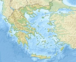
Zourafa or Ladoxera (Greek: Ζουράφα or Λαδόξερα) is a Greek uninhabited islet located in the prefecture of Evros, and specifically in the nearby distance east of Samothrace, and north of Imbros.[1] Its total area is only 9 sq.m. and the total length of the coastline 32 meters (in previous measurements 465 meters).[1] It belongs to the protected areas of the pan-European program NATURA since 2011,[2] and is the northeastern tip of the Thracian Sporades and the Greek maritime territory.[3]
Name[]
There appear to be various hypotheses about the origin of the first name. The earliest reference is to an Ottoman map of 1521 by the Ottoman explorer , which describes it as Zurata Kaya (modern Turkish: Zürafa Kayalay, Giraffe Rock) without being depicted, so its current name is alleged by some to be derived from this. On the contrary, the folklorist argues that it is a combination of the word "zoura" with the meaning of level and the word "fa" which has the meaning of light / manifest.[4][5] Variations of the same name are Sgorafa or Tzourafa.[6]
The name Ladoxera seems to derive from the presence of oily waters and the smell of oil.[1][3][4] Its alternate name, Ladoxera "oil reef", was given to it by sailors who would often spot oil slicks around Zourafa.[7]
In a Flemish map of 1585 it is called Halonesus, while in Venetian in the 1690s it appears to be referred to as Holonisus.[8][9]
Geography[]
Zourafa is located six nautical miles (11 km; 6.9 mi) east of Skepasto, the northeastern tip of the island of Samothrace, and 22 nautical miles (41 km; 25 mi) from Alexandroupoli. It has an estimated area of 9 square metres (97 sq ft) and measures 32 metres (0.020 mi) in circumference (undated). Zourafa has been gradually reduced in size by erosion. It peaks out of a 30-metre (98 ft) long underwater ledge, remnant of a volcanic island.[7] Sailors are cautioned about navigating in the vicinity of Zourafa.[10]
Zourafa is part of Greece, and there is a lighthouse on the island. In 2011, it was reported in Greek press that Turkey had started questioning the issue of treaties over the islet, however it is unclear if this is official Turkish policy (see Aegean dispute).[11][12]
Lighthouse[]
The lighthouse on Zourafa was destroyed by severe weather in the winter of 2012 and was rebuilt by September. The new lighthouse is powered by solar energy. An icon of Saint Nicholas was placed "in prominent view".[7] Saint Nicholas is the patron saint of sailors, and his icon is found on many ships and in many ports in Greece.[13][14]
Preservation[]
Zourafa comprises a Natura 2000-designated area, along with the Fengari mountain and eastern coastal region of Samothrace and the bordering sea.[15] The site was designated a Special Area of Conservation in 2011.[16]
References[]
- ^ a b c "ΖΟΥΡΑΦΑ -ΛΑΔΟΞΕΡΑ - Πανεπιστήμιο Αιγαίου".
- ^ "Προστατευόμενες περιοχές NATURA - Περιφερειακή Ενότητα Έβρου / Περιφέρεια Ανατολικής Μακεδονίας και Θράκης".
- ^ a b Θ. Σ. Λιάτης (June 2013). "Οι έρευνες για κοιτάσματα υδρογονανθράκων στην Ελλάδα" (PDF). Χημικά Χρονικά-Ένωση Ελλήνων Χημικών: 21. Cite journal requires
|journal=(help) - ^ a b "Η Βραχονησίδα Ζουράφα- Λαδόξερα και μία ακόμη μία αμφισβήτηση της εθνικής κυριαρχίας - του Θεοφάνη Μαλκίδη, Ελεύθερο Βήμα".
- ^ "Λεκάκης, Γιώργος Σαμοθράκη: Η ιερά νήσος - Θεσσαλονίκη, Ερωδιός 2006".
- ^ Σγοράφα ή Τζουράφα στο Νεώτερον Εγκυκλοπαιδικόν Λεξικόν Ηλίου τομ.16ος, σελ.901
- ^ a b c "Σαμοθράκη : Επαναλειτουργεί ο φάρος της βραχονησίδας "Ζουράφα"". agelioforos.gr (in Greek). 22 September 2012. Retrieved 7 July 2015.
- ^ Turkey and Gallipoli by Coronelli c.1694 Archived 2016-03-06 at the Wayback Machine και σε υψηλή ανάλυση Archived 2016-03-12 at the Wayback Machine - antiqueprints.com.au
- ^ (έγχρωμο) Paralello Geo Grafico Dell'antico Col Moderno Arcipelago και σε υψηλή ανάλυση Archived 2016-03-04 at the Wayback Machine - antiquemapsandglobes.com
- ^ National Geospatial-intelligence Agency (2005). Sailing directions (enroute) : Eastern Mediterranean (11th ed.). Annapolis, MD: Lighthouse Press. p. 229. ISBN 9781577856573.
- ^ Papaïoannou, Sofia (19 June 2011). "Η Αγκυρα αμφισβητεί το... μισό Αιγαίο". I Kathimerini (in Greek). Retrieved 7 July 2015.
- ^ Malkidis, Theofanis (14 January 2014). "Η Βραχονησίδα Ζουράφα- Λαδόξερα και μία ακόμη μία αμφισβήτηση της εθνικής κυριαρχίας". Elefthero Vima (in Greek). Retrieved 7 July 2015.
- ^ "Greece". St. Nicholas Center. Retrieved 8 July 2015.
- ^ "Patron Saint". St. Nicholas Center. Retrieved 8 July 2015.
- ^ "GR1110004 / FENGARI SAMOTHRAKIS, ANATOLIKES AKTES, VRACHONISSIDA ZOURAFA KAI THALASSIA ZONI". NATURA 2000. Retrieved 19 September 2015.
- ^ "Site factsheet for FENGARI SAMOTHRAKIS, ANATOLIKES AKTES, VRACHONISSIDA ZOURAFA KAI THALASSIA ZONI". European Nature Information System. European Environment Agency. Retrieved 8 July 2015.
- Uninhabited islands of Greece
- Samothrace
- Landforms of Evros (regional unit)
- Islands of Eastern Macedonia and Thrace
- Islands of Greece
