Île-Bonaventure-et-du-Rocher-Percé National Park
| Île-Bonaventure-et-du-Rocher-Percé National Park | |
|---|---|
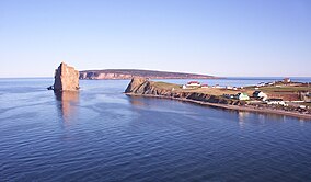 Percé Rock and village | |
| Location | Percé, Le Rocher-Percé Regional County Municipality, Quebec, Canada |
| www | |
Île-Bonaventure-et-du-Rocher-Percé National Park (French: Parc national de l'île-Bonaventure-et-du-Rocher-Percé) is a provincial park of Quebec.[1]
The park is located at the tip of the Gaspé Peninsula near the village of Percé, Quebec, and was created in 1985 to protect the large migratory bird sanctuary found on Bonaventure Island, as well as nearby Percé Rock just off the mainland. The park's area covers 5.8 km2, of which only a small portion is located on the mainland.
Boat and island tours are offered from May to October. The island features five hiking trails. Park wardens and naturalists also offer guided bird, fossil and geology walks and tours.
The park's main interpretation centre is located on the mainland in Percé, in a restored building known as Le Chafaud. The exhibits focus on the park's bird colonies, marine life, ecosystem, geology and history.[2] There are about 250,000 birds in the park.[3]
References[]
- This article was initially translated from the French Wikipedia.
- ^ Registre des aires protégées du Québec, Ministère du Développement durable, de l'Environnement et des Parcs. (in French)
- ^ http://www.bonjourquebec.com/qc-en/attractions-directory/museum-interpretation-centre-historic-site/interpretation-centre-of-parc-national-de-lile-bonaventure-et-du-rocher-perce_1229628.html
- ^ "Gaspe, Canada". Princess Explorations Café (Powered by the New York Times). 2016.
External links[]
- Parc national de l'île-Bonaventure-et-du-Rocher-Percé - official site in English
- Parc national de l'île-Bonaventure-et-du-Rocher-Percé - Tourism Gaspésie information
- Additional tour information
Coordinates: 48°29′47″N 64°09′43″W / 48.4964°N 64.1619°W

This Canadian protected area related article is a stub. You can help Wikipedia by . |
This Quebec location article is a stub. You can help Wikipedia by . |
- IUCN Category III
- National parks of Quebec
- Protected areas of Gaspésie–Îles-de-la-Madeleine
- Museums in Gaspésie–Îles-de-la-Madeleine
- Natural history museums in Canada
- Tourist attractions in Gaspésie–Îles-de-la-Madeleine
- Canadian protected area stubs
- Quebec geography stubs