Percé, Quebec
Percé | |
|---|---|
City | |
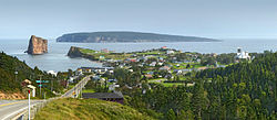 Percé with Percé Rock and Bonaventure Island in the background | |
 Coat of arms | |
 Location within Le Rocher-Percé RCM | |
 Percé Location in eastern Quebec | |
| Coordinates: 48°32′N 64°13′W / 48.533°N 64.217°WCoordinates: 48°32′N 64°13′W / 48.533°N 64.217°W[1] | |
| Country | Canada |
| Province | Quebec |
| Region | Gaspésie–Îles-de-la-Madeleine |
| RCM | Le Rocher-Percé |
| Settled | 1800s |
| Constituted | January 1, 1971 |
| Government | |
| • Mayor | Cathy Poirier |
| • Federal riding | Gaspésie—Îles-de-la-Madeleine |
| • Prov. riding | Gaspé |
| Area | |
| • Total | 550.30 km2 (212.47 sq mi) |
| • Land | 431.37 km2 (166.55 sq mi) |
| Population (2016)[3] | |
| • Total | 3,103 |
| • Density | 7.2/km2 (19/sq mi) |
| • Pop 2011-2016 | |
| • Dwellings | 1,880 |
| Time zone | UTC−5 (EST) |
| • Summer (DST) | UTC−4 (EDT) |
| Postal code(s) | G0C 2L0 |
| Area code(s) | 418 and 581 |
| Highways | |
| Website | www |

Percé is a small city near the tip of the Gaspé Peninsula in Quebec, Canada. Within the territory of the city there is a village community also called Percé.
Percé, member of the association of Most Beautiful Villages of Quebec, is mainly a tourist location particularly well known for the attractions of Percé Rock and Bonaventure Island.
In addition to Percé itself, the town's territory also includes the communities of Barachois, Belle-Anse, Bougainville, Bridgeville, Cap-d'Espoir, Cannes-de-Roches, Coin-du-Banc, L'Anse-à-Beaufils, Pointe-Saint-Pierre, Rameau, Saint-Georges-de-Malbaie, and Val-d'Espoir.
Percé is the seat of the judicial district of Gaspé.[4]
History[]
The area was within the traditional homelands of the Mi'kmaq people, who called the place Sigsôg ("steep rocks" or "crags") and Pelseg ("fishing place"). In 1603, Samuel de Champlain visited the area and named the famous rock Isle Percée ("Pierced Island"). During the 17th century, the place was used primarily as a stop-over for ships travelling to Quebec.[1]

Used as a seasonal fishing centre during the New France era, permanent settlement began in the early 19th century with the arrival of Irish, French Canadian, and Jersey natives. In 1801 the Parish of Saint-Michel-de-Percé was founded.[1] Percé became the most important fishing location on the Gaspé Peninsula[citation needed] after Charles Robin, a native of Jersey, began his fishing establishment. Old buildings of the Charles Robin Company can still be seen there.
In 1842, the geographic township of Percé was formed, and 3 years later, the place was incorporated as a township municipality.[1]
In 1942, the Royal Canadian Navy made a decision to expand Direction Finding and wireless intercept at Cap D'Espoir to a 24-hour basis in order to provide more bearings on German U-boats and to intercept enemy radio traffic. The Department of Transport placed its facilities at the disposal of the RCN. On May 21/45, the Canadian Naval Service approved the closing down and disposal of Harbour Grace and Cap D'Espoir intercept stations.
In 1971, Percé was greatly expanded and gained ville (town) status when it amalgamated with these 5 surrounding municipalities (with year of original incorporation):[1]
- Municipality of Barachois (1953)
- Municipality of Bridgeville (1933)
- Municipality of Cap-d'Espoir (1935)
- Municipality of Saint-Pierre-de-la-Malbaie N°1 (1876)
- Municipality of Saint-Pierre-de-la-Malbaie N°2 (1876)
Demographics[]
Population[]
| hideCanada census – Percé, Quebec community profile | |||
|---|---|---|---|
| 2016 | 2011 | 2006 | |
| Population: | 3,103 (-6.3% from 2011) | 3,312 (-3.1% from 2006) | 3,419 (-5.4% from 2001) |
| Land area: | 431.37 km2 (166.55 sq mi) | 432.39 km2 (166.95 sq mi) | 432.39 km2 (166.95 sq mi) |
| Population density: | 7.2/km2 (19/sq mi) | 7.7/km2 (20/sq mi) | 7.9/km2 (20/sq mi) |
| Median age: | 55.4 (M: 54.3, F: 56.3) | 51.9 (M: 51.1, F: 52.7) | 48.4 (M: 48.1, F: 49.0) |
| Total private dwellings: | 1,880 | 1,907 | 1,839 |
| Median household income: | $44,826 | $36,524 | $33,973 |
| References: 2016[5] 2011[6] 2006[7] earlier[8] | |||
|
| |||||||||||||||||||||||||||||||||
| Source: Statistics Canada[9] | ||||||||||||||||||||||||||||||||||
Language[]
| Canada Census Mother Tongue - Percé, Quebec[9] | ||||||||||||||||||
|---|---|---|---|---|---|---|---|---|---|---|---|---|---|---|---|---|---|---|
| Census | Total | French
|
English
|
French & English
|
Other
| |||||||||||||
| Year | Responses | Count | Trend | Pop % | Count | Trend | Pop % | Count | Trend | Pop % | Count | Trend | Pop % | |||||
2011
|
3,310
|
2,595 | 78.40% | 665 | 20.09% | 40 | 1.21% | 10 | 0.30% | |||||||||
2006
|
3,420
|
2,695 | 78.80% | 645 | 18.86% | 15 | 0.44% | 65 | 1.90% | |||||||||
2001
|
3,610
|
2,895 | 80.19% | 700 | 19.39% | 15 | 0.42% | 0 | 0.00% | |||||||||
1996
|
3,950
|
3,170 | n/a | 80.25% | 705 | n/a | 17.85% | 60 | n/a | 1.52% | 15 | n/a | 0.38% | |||||
Tourism[]
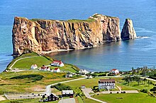
Percé Rock is a natural rock formation located close to the shore facing the town. It is a natural tourist attraction for its size, colour, and unusual door-like hole at one end of the rock. It can be seen from any of the belvederes in the area including Mont Joli, Mont Sainte-Anne and Pic de l'Aurore. Tourists can walk up to the hole in the rock at low tide.
Bonaventure Island occupies an area of 4.16 square km facing the town of Percé. It is populated by one of the most important gannet colonies in the world and many other species of birds such as puffins, cormorants and murres also use the island as a home and breeding ground.[10]
Whale watching is also a popular attraction in local area, and most notably, North Atlantic right whales, one of the rarest whales, had begun to concentrate off Percé in 1995 (this species was used to be regarded as sporadic visitors into the Gulf of St. Lawrence until 1994, and gradual increases have been confirmed in the entire St. Lawrence since 1998),[11] and Gaspe Peninsula has become the centre of sightings in St. Lawrence region.[12]
Further inland from Percé lies Mount Blanc which has a deep crevasse, as well as many other belvederes that overlook . , with a height of 375 metres, provides views of the sea and, during times of good visibility, Miscou Island in New Brunswick can be seen.
Les Percéides, an annual film festival in Percé, screens a weeklong series of films at various venues in the town, climaxing in an outdoor gala screening on the public beach.
Transportation[]

Percé can be accessed via Route 132, coming either from the north or the south. It is also reachable by air from the nearby Du Rocher-Percé Airport via private or charter aircraft - there is no scheduled air service to this airport. There was a rail link to Montreal, but that service was suspended in 2013, and there has been no indication of a resumption.
Behind the St. Michael’s Church of Percé, walking trails lead up past lookouts to the summit of Mont Saint-Anne of 348 metres (1,142 ft), the Grotto of Mother Mary with a waterfall and Crevasse. Another high hill, Mont-Blanc, has views of the region.
In the coastal waters, visitors can observe various species of marine mammals, such as seals and whales. The region is home to thousands of marine birds, which crowd the rocks of the Parc national de l’Ile-Bonaventure-et-du-Rocher-Percé facing of the town, just 3.2 kilometres off the coast of Percé.
Local government[]
List of former mayors:
This list is incomplete; you can help by . (April 2021) |
- Georges Mamelonet (2003–2008)
- Denis Cain (2009–2009)
- Bruno Cloutier (2009-2013)
- André Boudreau (2013-2017)
- Cathy Poirier (2017-present)
See also[]
- List of cities in Quebec
References[]
- ^ Jump up to: a b c d e "Percé (ville)" (in French). Commission de toponymie du Québec. Retrieved 2011-12-07.
- ^ Jump up to: a b "Percé". Répertoire des municipalités (in French). Ministère des Affaires municipales, des Régions et de l'Occupation du territoire. Archived from the original on 2012-05-01. Retrieved 2011-12-07.
- ^ Jump up to: a b "(Code 2402005) Census Profile". 2016 census. Statistics Canada. 2017.
- ^ Territorial Division Act. Revised Statutes of Quebec D-11.
- ^ "2016 Community Profiles". 2016 Canadian Census. Statistics Canada. February 21, 2017. Retrieved 2021-04-16.
- ^ "2011 Community Profiles". 2011 Canadian Census. Statistics Canada. July 5, 2013. Retrieved 2014-01-28.
- ^ "2006 Community Profiles". 2006 Canadian Census. Statistics Canada. March 30, 2011. Retrieved 2011-12-07.
- ^ "2001 Community Profiles". 2001 Canadian Census. Statistics Canada. February 17, 2012.
- ^ Jump up to: a b 1996, 2001, 2006, 2011 census
- ^ "Canadian Important Bird Areas". Ibacanada.ca. Retrieved 2012-12-05.
- ^ http://baleinesendirect.org/une-baleine-noire-en-vue-merci-dappeler-urgences-mammiferes-marins/
- ^ http://ici.radio-canada.ca/regions/est-quebec/2015/08/21/010-baleine-noire-roter-sand-mission-golfe-saint-laurent.shtml
External links[]
| Wikimedia Commons has media related to Percé. |
| Wikivoyage has a travel guide for Percé. |
| show Adjacent Municipal Subdivisions |
|---|
| hide | |
|---|---|
| Cities | |
| Municipalities | |
| Unorganized Territory | |
| |
| show Authority control |
|---|
- Populated coastal places in Canada
- Incorporated places in Gaspésie–Îles-de-la-Madeleine
- Cities and towns in Quebec