Grosse-Île, Quebec
Grosse-Île
Grosse-Île | |
|---|---|
Municipality | |
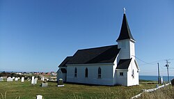
 Saint Peter By the Sea Church in Grosse-Île | |
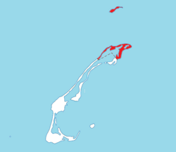
 Location within Les Îles-de-la-Madeleine TE. | |
 Grosse-Île Location in eastern Quebec. | |
| Coordinates: 47°37′N 61°31′W / 47.617°N 61.517°WCoordinates: 47°37′N 61°31′W / 47.617°N 61.517°W[1] | |
| Country | |
| Province | |
| Region | Gaspésie–Îles-de-la-Madeleine |
| RCM | None |
| Agglomeration | Les Îles-de-la-Madeleine |
| Constituted | January 1, 2006 |
| Government | |
| • Mayor | Rose Elmonde Clarke |
| • Federal riding | Gaspésie—Îles-de-la-Madeleine |
| • Prov. riding | Îles-de-la-Madeleine |
| Area | |
| • Total | 96.60 km2 (37.30 sq mi) |
| • Land | 37.59 km2 (14.51 sq mi) |
| Population (2016)[3] | |
| • Total | 465 |
| • Density | 12.4/km2 (32/sq mi) |
| • Change 2011-2016 | |
| • Dwellings | 254 |
| Time zone | UTC−5 (EST) |
| • Summer (DST) | UTC−4 (EDT) |
| Postal code(s) | G4T 6B9 |
| Area code(s) | 418 and 581 |
| Highways | |
| Website | www |
Grosse-Île is one of two municipalities forming the urban agglomeration of Îles-de-la-Madeleine in Quebec, Canada. It is part of the Gaspésie–Îles-de-la-Madeleine region, and its population was 465 as of the 2016 Census.
As part of a municipal reorganization across Quebec, the seven communities of the Magdalen Islands amalgamated to form the municipality of Les Îles-de-la-Madeleine on January 1, 2002. However, after a 2004 referendum, Grosse-Île decided to split from the municipality, effective January 1, 2006.
Located on (French for Big Island) between Les Îles-de-la-Madeleine's villages of Grande-Entrée (south) and House Harbour (southwest), it was settled during the late 18th century by Scots. French-speaking people would come and establish themselves just after, as seen by a Catholic parish founded in 1793. Today, Grosse-Île remains one of three communities of the archipelago to be predominantly English-speaking, the other being Entry Island and Old Harry (a hamlet part of Grosse-Île on ).
Demographics[]

Population[]
| hideCanada census – Grosse-Île, Quebec community profile | |||
|---|---|---|---|
| 2016 | 2011 | 2006 | |
| Population: | 465 (-5.1% from 2011) | 490 (-7.7% from 2006) | 531 (-2.2% from 2001) |
| Land area: | 37.59 km2 (14.51 sq mi) | 37.29 km2 (14.40 sq mi) | 37.29 km2 (14.40 sq mi) |
| Population density: | 12.4/km2 (32/sq mi) | 13.1/km2 (34/sq mi) | 14.2/km2 (37/sq mi) |
| Median age: | 49.1 (M: 50.0, F: 48.9) | 43.8 (M: 43.6, F: 44.0) | 40.5 (M: 40.0, F: 41.1) |
| Total private dwellings: | 254 | 229 | 231 |
| Median household income: | $81,152 | $.N/A | $58,716 |
| Notes: 2011 income data for this area has been suppressed for data quality or confidentiality reasons. – References: 2016[4] 2011[5] 2006[6] earlier[7] | |||
|
| ||||||||||||||||||||||||
| [8][3] | |||||||||||||||||||||||||
Language[]
| Canada Census Mother Tongue - Grosse-Île, Quebec[8] | ||||||||||||||||||
|---|---|---|---|---|---|---|---|---|---|---|---|---|---|---|---|---|---|---|
| Census | Total | French
|
English
|
French & English
|
Other
| |||||||||||||
| Year | Responses | Count | Trend | Pop % | Count | Trend | Pop % | Count | Trend | Pop % | Count | Trend | Pop % | |||||
2016
|
465
|
60 | 12.90% | 395 | 84.95% | 5 | 1.08% | 5 | n/a | 1.08% | ||||||||
2011
|
490
|
50 | 10.20% | 430 | 87.76% | 10 | 2.04% | 0 | 0.00% | |||||||||
2006
|
530
|
25 | 4.72% | 505 | 95.28% | 0 | 0.00% | 0 | 0.00% | |||||||||
2001
|
535
|
75 | 14.02% | 460 | 85.98% | 0 | 0.00% | 0 | 0.00% | |||||||||
1996
|
570
|
60 | n/a | 10.53% | 500 | n/a | 87.72% | 10 | n/a | 1.75% | 0 | n/a | 0.00% | |||||
See also[]
References[]
- ^ Reference number 388449 of the Commission de toponymie du Québec (in French)
- ^ Jump up to: a b Geographic code 01042 in the official Répertoire des municipalités (in French)
- ^ Jump up to: a b c "Census Profile, 2016 Census: Grosse-Île, Municipalité [Census subdivision], Quebec". Statistics Canada. Retrieved November 29, 2019.
- ^ "2016 Community Profiles". 2016 Canadian Census. Statistics Canada. February 21, 2017. Retrieved 2019-11-29.
- ^ "2011 Community Profiles". 2011 Canadian Census. Statistics Canada. July 5, 2013. Retrieved 2014-02-23.
- ^ "2006 Community Profiles". 2006 Canadian Census. Statistics Canada. March 30, 2011. Retrieved 2014-02-23.
- ^ "2001 Community Profiles". 2001 Canadian Census. Statistics Canada. February 17, 2012.
- ^ Jump up to: a b Statistics Canada: 1996, 2001, 2006, 2011 census
- Commission de toponymie du Québec
- Ministère des Affaires municipales, des Régions et de l'Occupation du territoire
- Incorporated places in Gaspésie–Îles-de-la-Madeleine
- Municipalities in Quebec
- Magdalen Islands

