Cap-Chat, Quebec
Cap-Chat | |
|---|---|
City | |
 | |
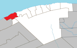 Location within La Haute-Gaspésie RCM. | |
 Cap-Chat Location in eastern Quebec. | |
| Coordinates: 49°06′N 66°41′W / 49.100°N 66.683°WCoordinates: 49°06′N 66°41′W / 49.100°N 66.683°W[1] | |
| Country | |
| Province | |
| Region | Gaspésie–Îles-de-la-Madeleine |
| RCM | La Haute-Gaspésie |
| Settled | 1815 |
| Constituted | March 15, 2000 |
| Government | |
| • Mayor | Marie Gratton |
| • Federal riding | Gaspésie—Les Îles-de-la-Madeleine |
| • Prov. riding | Gaspé |
| Area | |
| • Total | 207.40 km2 (80.08 sq mi) |
| • Land | 181.89 km2 (70.23 sq mi) |
| Population | |
| • Total | 2,623 |
| • Density | 14.4/km2 (37/sq mi) |
| • Pop 2006-2011 | |
| • Dwellings | 1,368 |
| Time zone | UTC−5 (EST) |
| • Summer (DST) | UTC−4 (EDT) |
| Postal code(s) | G0J 1E0 |
| Area code(s) | 418 and 581 |
| Highways | |
| Website | ville |

Cap-Chat is a town in the Canadian province of Québec, in the Regional County Municipality of Haute-Gaspésie, and in the administrative region of Gaspésie-Îles-de-la-Madeleine. Cap-Chat is found 16 kilometres (9.9 mi) west of Sainte-Anne-des-Monts. As of 2006, Cap-Chat's population is 2,777.[4]
In addition to Cap-Chat itself, the town's territory also includes the communities of Cap-Chat-Est, Capucins, and Petit-Fonds.
History[]

There are two theories about the origin of the town's name. One simply holds that the headland called Cap-Chat bore a likeness to a cat ("chat" in French). The other theory is a bit more fanciful. According to a local legend, a cat walking along the shore killed and ate various animals, whereupon the "cat fairy" accused him of having eaten her offspring. For his punishment, the cat was turned into stone for ever.
It seems most likely, however, that the town's name is a corruption of "Aymar de Chaste", who was New France's lieutenant-general in 1603.
The waterfront boardwalk at Cap-Chat has a display of photographs and informative plaques regarding the Second World War Battle of the St. Lawrence between U-Boats and coastal defence ships.
Cap-Chat was one of the prime viewing areas for the total solar eclipse of July 10, 1972. Unfortunately, cloudy skies prevented most observers from viewing the total phase of the eclipse.
On March 15, 2000, the Municipality of Capucins was amalgamated into the Town of Cap-Chat.[1]
Demographics[]

Population[]
| hideCanada census – Cap-Chat, Quebec community profile | |||
|---|---|---|---|
| 2011 | 2006 | ||
| Population: | 2,623 (-5.5%% from 2006) | 2,777 (-4.7% from 2001) | |
| Land area: | 181.89 km2 (70.23 sq mi) | 181.89 km2 (70.23 sq mi) | |
| Population density: | 14.4/km2 (37/sq mi) | 15.3/km2 (40/sq mi) | |
| Median age: | 53.7 (M: 53.1, F: 54.5) | 50.1 (M: 49.6, F: 50.6) | |
| Total private dwellings: | 1,368 | 1,347 | |
| Median household income: | $37,511 | $31,051 | |
| Notes: Municipality of Capucins was amalgamated into the Town of Cap-Chat on March 15, 2000. – References: 2011[5] 2006[6] earlier[7] | |||
|
|
|
Economy[]
Cap-Chat has become synonymous with wind energy. There is a wind farm there containing 76 wind generators in revenue service. Each one of these is a horizontal axis wind turbine (HAWT), but there is also to be seen there one called Éole, which is the world's tallest vertical axis wind turbine (VAWT) at 110 m. It is capable of producing 4 MW of power, but has not been in use for more than ten years following damages sustained during a wind storm. Everything that there is to know about wind power at Cap-Chat may be learnt at the interpretative centre at the wind farm.
Cap-Chat has other things that are worth seeing, such as the aforesaid cat-shaped headland, and a lighthouse.
Those interested in wilderness and spectacular scenery can explore the areas inland from Cap-Chat, where there was once a village called Saint-Octave-de-l'Avenir (which ironically means Saint Octavius of the Future, though it's long in the past now). Salmon fishing and moose hunting are other activities available in the Cap-Chat area, as are hiking, horseback riding, and off-road four-wheel drive excursions in the back country.
In winter, Cap-Chat has a downhill skiing centre, as well as trails for cross-country skiing, snowshoeing, and snowmobiling.
Images[]
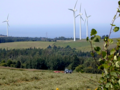
Wind turbines at Cap-Chat

Wind farm
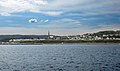
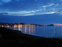
The village, as seen from the sea

Lighthouse

Backcountry


See also[]
- List of cities in Quebec
References[]
- ^ Jump up to: a b "Cap-Chat (Ville)" (in French). Commission de toponymie du Québec. Retrieved 2011-12-19.
- ^ Jump up to: a b "Cap-Chat". Répertoire des municipalités (in French). Ministère des Affaires municipales, des Régions et de l'Occupation du territoire. Archived from the original on 2012-05-01. Retrieved 2011-12-19.
- ^ Jump up to: a b "Cap-Chat census profile". 2011 Census data. Statistics Canada. Retrieved 2011-12-19.
- ^ "Cap-Chat community profile". 2006 Census data. Statistics Canada. Retrieved 2011-12-19.
- ^ "2011 Community Profiles". 2011 Canadian Census. Statistics Canada. July 5, 2013. Retrieved 2014-01-28.
- ^ "2006 Community Profiles". 2006 Canadian Census. Statistics Canada. March 30, 2011. Retrieved 2011-12-19.
- ^ "2001 Community Profiles". 2001 Canadian Census. Statistics Canada. February 17, 2012.
- ^ Statistics Canada: 1996, 2001, 2006, 2011 census
External links[]
| Wikimedia Commons has media related to Cap-Chat. |
- Cap-Chat tourism site
- Éole interpretative centre at the wind farm
- Municipalities and cities of Gaspé region
| show Adjacent Municipal Subdivisions |
|---|
| hide | |
|---|---|
| Cities | |
| Municipalities | |
| Villages | |
| Unorganized Territories | |
| |
| show Authority control |
|---|
- Cities and towns in Quebec
- Incorporated places in Gaspésie–Îles-de-la-Madeleine