Mont-Albert, Quebec
Mont-Albert | |
|---|---|
Unorganized territory | |
 Mount Albert | |
 Location within La Haute-Gaspésie RCM. | |
 Mont-Albert Location in eastern Quebec. | |
| Coordinates: 48°55′N 66°11′W / 48.917°N 66.183°WCoordinates: 48°55′N 66°11′W / 48.917°N 66.183°W[1] | |
| Country | |
| Province | |
| Region | Gaspésie–Îles-de-la-Madeleine |
| RCM | La Haute-Gaspésie |
| Constituted | January 1, 1986 |
| Government | |
| • Federal riding | Gaspésie—Les Îles-de-la-Madeleine |
| • Prov. riding | Gaspé |
| Area | |
| • Total | 3,457.10 km2 (1,334.79 sq mi) |
| • Land | 3,470.44 km2 (1,339.94 sq mi) |
| There is an apparent contradiction between two authoritative sources | |
| Population | |
| • Total | 204 |
| • Density | 0.1/km2 (0.3/sq mi) |
| • Pop 2006-2011 | |
| • Dwellings | 87 |
| Time zone | UTC-5 (EST) |
| • Summer (DST) | UTC-4 (EDT) |
| Postal code(s) | G0E 2G0 |
| Area code(s) | 418 and 581 |
| Highways | |

Mont-Albert is an unorganized territory in the Gaspésie–Îles-de-la-Madeleine region of Quebec, Canada.
The only population centre within the territory is Cap-Seize, located 14 kilometres (8.7 mi) south of Sainte-Anne-des-Monts along Quebec Route 299. It was established circa 1940 as a forestry centre and named after the nearby Cap-Seize Creek, a tributary of the Sainte-Anne River. While the name literally means "Cape Sixteen", it is actually a transformation of the English word "capsize", the creek's original name. A post office operated there from 1946 to 1969.[4]
The ghost town of Saint-Octave-de-l'Avenir is about 18 kilometres (11 mi) south-southeast of Cap-Chat, at an altitude of 380 metres (1,250 ft). It was formed in 1932 as part of the Vautrin Settlement Plan to encourage colonization of Gaspésie's interior and intended to bring relief during the Great Depression of the 1930s. The settlement was named after founding priest Louis-Octave Caron (1879–1942) and a hopeful outlook of the future (avenir is French for "future"). It grew to 1200 residents in 1937 but then declined until it was abandoned in 1971. Only summer camps remain.[5]
The territory is home to the and Gaspésie National Park where the eponymous Mount Albert and Mont Jacques-Cartier are located. Mount Albert, with a 1,151-metre-high (3,776 ft) peak, is the 9th highest peak in Quebec. It was named in honour of Prince Albert of Saxe-Coburg and Gotha because geologist Alexander Murray made the first recorded ascent of the mountain on the Prince's birthday, 26 August 1845. Mount Jacques-Cartier, with an altitude of 1,270 metres (4,170 ft), is Quebec's second highest mountain.[6][7]
Both mountains are popular with hikers (the International Appalachian Trail traverses them both) and share a unique ecology for its latitude: snow cover for 9 months of the year and alpine tundra vegetation. Furthermore, the territory is also home to migratory woodland caribou, the only remaining herd south of the Saint Lawrence.[6][8]
Demographics[]
| hideCanada census – Mont-Albert, Quebec community profile | |||
|---|---|---|---|
| 2011 | 2006 | ||
| Population: | 204 (-6.4% from 2006) | 218 (-1.8% from 2001) | |
| Land area: | 3,470.44 km2 (1,339.94 sq mi) | 3,470.44 km2 (1,339.94 sq mi) | |
| Population density: | 0.1/km2 (0.26/sq mi) | 0.1/km2 (0.26/sq mi) | |
| Median age: | 44.4 (M: 47.6, F: 41.5) | 44.0 (M: 46.3, F: 41.5) | |
| Total private dwellings: | 87 | 92 | |
| Median household income: | $.N/A | $.N/A | |
| Notes: Income data for this area has been suppressed for data quality or confidentiality reasons. – References: 2011[3] 2006[9] earlier[10] | |||
|
|
|
Notable people[]
- Thérèse Dion (1927–2020), television personality and the mother of singer Céline Dion[12]
Gallery[]
Trail leading to the summit of Mont Jacques-Cartier

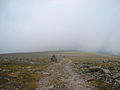
Plateau at the summit of Mount Albert

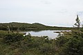
Lac aux Américains

Grande Cuve of Mount Albert
Lake on the plateau at the summit of Mount Albert

Snowpack and waterfall, Grande Cuve, Mount Albert

Shrubs on the plateau at the summit of Mount Albert

Flora on Mount Albert

Flora, Grande Cuve, Mount Albert

Flora, Grande Cuve, Mount Albert


See also[]
References[]
- ^ Reference number 149673 of the Commission de toponymie du Québec (in French)
- ^ Jump up to: a b "Mont-Albert". Répertoire des municipalités (in French). Ministère des Affaires municipales, des Régions et de l'Occupation du territoire. Archived from the original on 2012-05-01. Retrieved 2011-12-20.
- ^ Jump up to: a b c "2011 Community Profiles". 2011 Canadian Census. Statistics Canada. July 5, 2013. Retrieved 2013-05-14.
- ^ "Cap-Seize" (in French). Commission de toponymie du Québec. Retrieved 2011-12-21.
- ^ "Saint-Octave-de-l'Avenir" (in French). Commission de toponymie du Québec. Retrieved 2011-12-21.
- ^ Jump up to: a b "Mont Albert" (in French). Commission de toponymie du Québec. Retrieved 2011-12-21.
- ^ "Mont Jacques Cartier". Peakery. Archived from the original on 2011-10-15. Retrieved 2011-12-21.
- ^ "Parc National de la Gaspesie". Sepaq. Retrieved 2011-12-22.
- ^ "2006 Community Profiles". 2006 Canadian Census. Statistics Canada. March 30, 2011. Retrieved 2011-12-20.
- ^ "2001 Community Profiles". 2001 Canadian Census. Statistics Canada. February 17, 2012.
- ^ Statistics Canada: 1996, 2001, 2006, 2011 census
- ^ Kussin, Zachary (2020-01-17). "Celine Dion's mom, Thérèse Dion, dead at 92". New York Post. Retrieved 2020-12-02.
| show Adjacent Municipal Subdivisions |
|---|
| hide | |
|---|---|
| Cities | |
| Municipalities | |
| Villages | |
| Unorganized Territories | |
| |
- Unorganized territories in Gaspésie-Îles-de-la-Madeleine