Île Jésus
show This article may be expanded with text translated from the corresponding article in French. (January 2018) Click [show] for important translation instructions. |
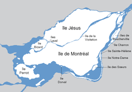 Map of the Hochelaga Archipelago, with Île Jésus at the north | |
 Île Jésus | |
| Geography | |
|---|---|
| Location | Saint Lawrence River Rivière des Mille Îles |
| Coordinates | 45°35′N 73°45′W / 45.583°N 73.750°WCoordinates: 45°35′N 73°45′W / 45.583°N 73.750°W |
| Archipelago | Hochelaga Archipelago |
| Area | 242 km2 (93 sq mi) |
| Administration | |
Canada | |
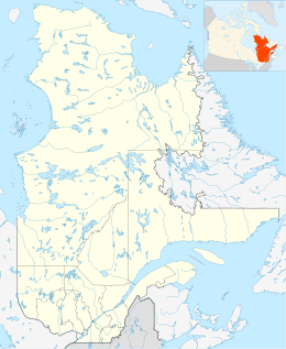
| Territory | Quebec |
| City | Laval |
| Demographics | |
| Population | 422,993 (2016) |

Île Jésus (French: [il ʒezy], Jesus Island) is a river island in southwestern Quebec, separated from the mainland to the north by the Rivière des Mille Îles, and from the Island of Montreal to the south by the Rivière des Prairies.
The second-largest (242 km2 (93 sq mi)) island in the Hochelaga Archipelago (after the Island of Montreal), Île Jésus is the major component of the City of Laval, along with the Îles Laval and several other islands. The island still has a considerable rural portion, with most of the urban area in the central region and along the south and west river banks.
Former cities[]
|
|
See also[]
- Olivier Charbonneau
- List of islands of Quebec
External links[]
- City of Laval official website
- www.INFOLaval.com Online Commercial and Industrial directory of the island of Laval. (French - English)
| Authority control |
|
|---|
This Quebec location article is a stub. You can help Wikipedia by . |
Categories:
- Hochelaga Archipelago
- Landforms of Laval, Quebec
- Quebec geography stubs