Rivière des Prairies
| Rivière des Prairies | |
|---|---|
 Aerial view looking east, of Rivière des Prairies with Louis Bisson Bridge in the foreground. The island "Ile aux Chats" can be seen near the centre. | |
| Location | |
| Country | Canada |
| Province | Quebec |
| Region | Montreal and Laval |
| Physical characteristics | |
| Source | |
| • location | Lake of Two Mountains |
| Mouth | |
• location | Saint Lawrence River |
The Rivière des Prairies (pronounced [ʁivjɛʁ de pʁɛʁi]; literally River of the Prairies, sometimes called the Back River in English)[1][2][3][4] is a delta channel of the Ottawa River in southwestern Quebec, Canada. The Kanien'kehá:ka called it Skowanoti, meaning "River behind the island".[5] The river separates the cities of Laval and Montreal.
Geography[]
Flowing west to east, the Rivière des Prairies bisects the Hochelaga Archipelago and originates in the Lake of Two Mountains. It flows on either side of Île Bizard (part of Montreal), then divides the Island of Montreal (Montreal) to the south from Île Jésus (Laval) to the north, after which it flows into the St. Lawrence River at the eastern tip of the Island of Montreal.
The river contains a large number of islands, including Île Bizard, the Îles Laval (Île Bigras, Île Pariseau, Île Verte and Île Ronde) belonging to Laval, and Île de la Visitation, a nature park belonging to Montreal. There are also islands named Île Mercier, Île Ménard, Île Jasmin, Île Barwick, Île de Roxboro, Île aux Chats, Île Paton, Île Perry, Île Lapierre, Île Boutin, Île Rochon and Île Gagné.
The Rivière des Prairies has many rapids. Rapids are shown in several places on the 1879 map of Henry Whitmersome Hopkins,[3] and on Gordon and Gotch's map of the Island of Montreal from 1924.[2] Named rapids of the river, starting from the west, are the "Rapides de Cap-Saint-Jacques",[6] the Lalemant(Dutchman) Rapids[7] that are located between Île Bizard and Laval (with a ferry),[8] the "Rapides du Cheval Blanc"(Whitehorse rapids) that are located in between the borough of Pierrefonds-Roxboro and Sainte-Dorothée,[9] the Laval rapids, the "Sault-au-Récollet Rapids"[10] that are located north of Bordeaux Prison, and ending with the "Rapides de la Rivière des Prairies".[11]
The riverfront in the West Island area was famous for its beaches along the river. Some were named "Crystal",[12] "Noel/Roy",[13] "Riviera",[14] and Roxboro municipal beach [15][16][17][18]
Environmental issues[]
The river receives massive discharges of untreated liquid waste from metropolitan Montreal and the newly developed suburbs by way of over 150 discharge outlets. Whenever there is significant rainfall on the island of Montreal, household sewage is mixed with the city street rainwater and discharged untreated into the river.[19][20] This sewage turns the river into essentially an open sewer. The sewage problem was reported in the year 1911.,[21] and a need to purify Montreal sewage in 1935.[22] [23][24][25][26][27][28] The Montreal Board of Trade (BOT) commissioned a report on the water pollution in the late 1950s, and the report was given to Premier Barrette.[29]
Montreal has six drinking-water plants on the Island whose source of water is the Rivière des Prairies and Lac Saint Louis. Reportedly, Montreal and Quebec city drinking water is tested.[30]
It is claimed modern sewage treatment techniques have reversed much of the damage from the sewage.[31][32] Some people consider the river clean again, starting in the year 1998, when most of the sewage was treated before being discharged.[33] However, parts of the river are never suitable for swimming . Specifically the location of R.D.P. 140,[34] the Rive-Boisée area has been polluted since the year 1971[35] is still polluted from raw sewage more than forty years later .[36][37][38][39][40] The Rive-Boisée problem had been noticed and was reported to be repaired in 2014.[41] The reason for the sewage problem is that the storm sewer drain system and the sanitary sewer system were mistakenly connected in many places, and it takes money to correct and repair.[42] Reports from the R.S.M.A.(Réseau de suivi du milieu aquatique) dated 2021 on the water quality of RDP-140 indicate the problem has not been fixed.
From Bing maps, many of the sewage output locations can be seen on the river shoreline. The solution to the visible pollution (plastic bags, toilet paper, condoms) that accumulates on the shoreline is to use a type of a screen at all the storm drains and outlets that expel the rainwater-garbage mixture into the river.
See also[]
- Fecal-oral route Diseases that can be transmitted from feces in water.
- Hochelaga Archipelago
- List of bridges spanning the Rivière des Prairies
- List of crossings of the Rivière des Prairies
- List of hydroelectric stations
- List of Quebec rivers
- Saint Lawrence Seaway
References[]
- ^ Beauregard, Ludger (1968). Toponymie de la région métropolitaine de Montréal. Ministry of Lands and Forests of Quebec. p. 19. OCLC 5935170.
- ^ Jump up to: a b "the Island of Montreal" (PDF). Gordon and Gotch's map of the Island of Montreal compiled and drawn by Albert E. Dumont c1924 (9-10-11, H-J) "Back River" is written. Library and Archives Canada.
{{cite web}}: External link in|publisher= - ^ Jump up to: a b "Atlas of the city and island of Montreal". Titre : Atlas of the city and island of Montreal "Back River" is written. Bibliothèque et Archives nationales du Québec 1879.
- ^ "Montreal Island and Vicinity: Goad, Chas. E, (Charles Edward)". Titre : Montreal Island and Vicinity "Back River" is written. Bibliothèque et Archives nationales du Québec 1907.
- ^ "History — Neighbourhood Sault-au-Récollet". NEIGHBOURHOODS AND SITES. Heritage Montreal. Retrieved 30 April 2012.
- ^ Commission de toponymie Québec Rapides de Cap-Saint-Jacques
- ^ Dutchman rapids 45'32 73'51
- ^ Map of Rapides Lalemant, Quebec , Rapids - Canada Geographical Names with Maps
- ^ Les rapides du Cheval Blanc 1968-12-05
- ^ Map of Rapides du Sault au Récollet, Quebec , Rapids - Canada Geographical Names with Maps
- ^ Map of Rapides de la Rivière des Prairies, Quebec , Rapids - Canada Geographical Names with Maps
- ^ Plage Crystal, National Resources Canada
- ^ Plage Noël, National Resources Canada
- ^ Plage Riviera, National Resources Canada
- ^ "...local shoreline brought thousands of people out from Montreal to the commercial beaches out in the west ward". The North Shore News Editorial. July 16, 1970.
- ^ "Map of Pierrefonds(1998)". Map. Bibliothèque et Archives nationales du Québec Beach/Plage Crystal, Noel and Riviera.
- ^ "Roxboro residents warned: don't swim in the Back River". The Montreal Gazette. August 15, 1968.
- ^ "List of Current and Former Names" Natural Resources Canada
- ^ ""Montreal sewage waste dumped directly into rivers" CBC News, August 25, 2014". CBC Montreal News. 2014.
- ^ ""Millions of litres of sewage spilled into Montreal rivers" CBC News, August 25, 2014". CBC Montreal News. 2014.
- ^ ""Experts Report on Back River" The Montreal Gazette August 16, 1911". The Montreal Gazette. 1911.
- ^ ""Need for Purifying City Sewage Going to Riviere des Prairies Shown" The Montreal Gazette May 13, 1935". The Montreal Gazette. 1935.
- ^ ""Back River Ice Safe" The Montreal Gazette, March 29, 1944". The Montreal Gazette. 1944.
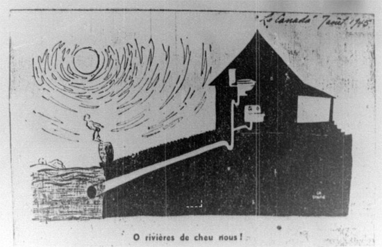
- ^ "O rivières de chou nous!". Editorial cartoon. 1945.
- ^ Editorial Cartoon of Riviere des prairies water pollution. North Shore News. August 15th 1968.
- ^ "Swimming in Sewage". The Montreal Gazette. August 30, 1973.
- ^ "Pierrefonds Pondering ($20,300) Sewage Judgement". The North Shore News. May 16, 1974.
- ^ "The Dirtiest Water in North America". The Montreal Gazette. July 5, 1980.
- ^ "Montreal Worst Offender in Water Pollution" The Montreal Gazette. February 26, 1960.
- ^ "Montreal, Quebec City drinking water tests satisfactory: experts" CBC news June 17, 2015
- ^ "Project Archipel: Is it a boon or boondoggle? "Riviere des Prairies should be clean enough for swimming by 1987" Andre Desroches. : Water Quality". The Montreal Gazette. June 21, 1982.
- ^ The Montreal Gazette "2.95 billion litres dumped daily" March 29, 1984
- ^ A History of Problems Under Montreal
- ^ RSMA list of locations of water sampling stations
- ^ Title "Pierrefonds appeals to Ottawa, Quebec for Rive Boisee solution" North Shore News. May 4, 1972.
- ^ "Raw sewage flowing into river from Pierrefonds". Max Harrold : The Montreal Gazette. July 2, 2009. Archived from the original on December 26, 2014.
- ^ "Sewage still pouring into river". Max Harrold : The Montreal Gazette. July 15, 2010. Archived from the original on December 26, 2014.
- ^ "Kirkland ups compensation for crossed pipes". By ALBERT KRAMBERGER : The Montreal Gazette. July 11, 2012.[permanent dead link]
- ^ "Sewage washing up on eastern Montreal shores". CBC News. July 25, 2012.
- ^ Le Réseau de suivi du milieu aquatique (RSMA). "Suivi de la qualité bactériologique des cours d'eau à Montréal". Réseau de suivi du milieu aquatique (RSMA).
- ^ Title "Pierrefonds tackles 133 cases of cross-connected pipes" Montreal Gazette, Cheryl Cornacchia, November 19, 2013
- ^ Title "Beaconsfield wins cross-connected pipes court case brought forward by homeowner" Montreal Gazette, March 5, 2014
External links[]
Further reading[]
- Agence de développement de réseaux locaux de services de santé et de services sociaux de Montréal (Québec). Health Care, in Your Neighbourhood. Health and Social Service Resources in the CLSC Rivière-des-Prairies District. Montreal: Agence de développement de réseaux locaux de services de santé et de services sociaux, Montreal, 2004.
- Canada. Bill An Act to Remove Certain Obstructions to the Navigation of the Rivière des Prairies, and to Repeal Certain Clauses of the Acts 10th and 11th Victoria, Cap. 97 and 98. Quebec: Thompson, 2003. ISBN 0-659-02570-1 (1860 Bibliographic record)
- Sylvie Paré. Impacts of Ethnic Changes on the Housing Market in the Rivière-des-Prairies District of Montreal. [Ottawa]: CMHC, 2006.
- Rybczynski, Witold, Avi Friedman, and Brenda Baxter. Urban Design for Affordability = Urbanisme Et Conception De Maisons Abordables, Rivière-des-Prairies. Montreal: Affordable Homes Program, School of Architecture, McGill University, 1991.
- Verdon, R., and M. Gendron. 1991. "Creation of Artificial Spawning Grounds Downstream of the Rivière-des-Prairies Spillway". Transactions — Canadian Electrical Association. Engineering and Operation Division. 30.
| Wikimedia Commons has media related to Rivière des Prairies. |
| hide | |||||||
|---|---|---|---|---|---|---|---|
| Features |
|  | |||||
| History | |||||||
| Geography | |||||||
| Economy |
| ||||||
| Politics | |||||||
| Public services | |||||||
| Education |
| ||||||
| Culture |
| ||||||
| Transportation | |||||||
| |||||||
Coordinates: 45°35′22″N 73°39′26″W / 45.58944°N 73.65722°W

- Rivière des Prairies
- Landforms of Laval, Quebec
- Landforms of Montreal
- Tributaries of the Saint Lawrence River