Čajetina
Čajetina
Чајетина (Serbian) | |
|---|---|
Village and municipality | |
   | |
 Coat of arms | |
 Location of the municipality of Čajetina within Serbia | |
| Coordinates: 43°45′N 19°43′E / 43.750°N 19.717°ECoordinates: 43°45′N 19°43′E / 43.750°N 19.717°E | |
| Country | |
| Region | Šumadija and Western Serbia |
| District | Zlatibor |
| Settlements | 20 |
| Government | |
| • Mayor | Milan Stamatović (ZS) |
| Area | |
| • Urban | 39.32 km2 (15.18 sq mi) |
| • Municipality | 647 km2 (250 sq mi) |
| Elevation | 843 m (2,766 ft) |
| Population (2011 census)[3] | |
| • Urban | 3,342 |
| • Urban density | 85/km2 (220/sq mi) |
| • Municipality | 14,745 |
| • Municipality density | 23/km2 (59/sq mi) |
| Time zone | UTC+1 (CET) |
| • Summer (DST) | UTC+2 (CEST) |
| Postal code | 31310 |
| Area code | +381(0)31 |
| Car plates | UE |
| Website | www |

Čajetina (Serbian Cyrillic: Чајетина) is a small town and municipality located in the Zlatibor District of western Serbia. According to the 2011 census results, the municipality has 14,745 inhabitants. One of the most notable settlements in the municipality of Čajetina is a popular tourist town of Zlatibor.
Climate[]
Čajetina has a humid continental climate (Köppen climate classification: Dfb).
| Climate data for Čajetina | |||||||||||||
|---|---|---|---|---|---|---|---|---|---|---|---|---|---|
| Month | Jan | Feb | Mar | Apr | May | Jun | Jul | Aug | Sep | Oct | Nov | Dec | Year |
| Average high °C (°F) | 1.2 (34.2) |
4.1 (39.4) |
9.0 (48.2) |
12.5 (54.5) |
17.3 (63.1) |
20.8 (69.4) |
23.0 (73.4) |
23.2 (73.8) |
19.9 (67.8) |
14.8 (58.6) |
7.5 (45.5) |
2.9 (37.2) |
13.0 (55.4) |
| Daily mean °C (°F) | −2.1 (28.2) |
0.3 (32.5) |
4.5 (40.1) |
7.7 (45.9) |
12.3 (54.1) |
15.7 (60.3) |
17.7 (63.9) |
17.7 (63.9) |
14.6 (58.3) |
10.1 (50.2) |
4.0 (39.2) |
−0.1 (31.8) |
8.5 (47.4) |
| Average low °C (°F) | −5.4 (22.3) |
−3.5 (25.7) |
0.0 (32.0) |
3.0 (37.4) |
7.4 (45.3) |
10.7 (51.3) |
12.4 (54.3) |
12.3 (54.1) |
9.3 (48.7) |
5.4 (41.7) |
0.5 (32.9) |
−3.1 (26.4) |
4.1 (39.3) |
| Average precipitation mm (inches) | 67 (2.6) |
59 (2.3) |
60 (2.4) |
75 (3.0) |
100 (3.9) |
99 (3.9) |
89 (3.5) |
74 (2.9) |
78 (3.1) |
77 (3.0) |
86 (3.4) |
76 (3.0) |
940 (37) |
| Source: Climate-Data.org [4] | |||||||||||||
Settlements[]
Aside from the town of Čajetina, the municipality comprises the following settlements:
- Alin Potok
- Branešci
- Golovo
- Gostilje
- Dobroselica
- Drenova
- Željine
- Zlatibor
- Jablanica
- Kriva Reka
- Ljubiš
- Mačkat
- Mušvete
- Rakovica
- Rožanstvo
- Rudine
- Sainovina
- Semegnjevo
- Sirogojno
- Stublo
- Tripkova
- Trnava
- Šljivovica
Demographics[]
| Year | Pop. | ±% p.a. |
|---|---|---|
| 1948 | 20,266 | — |
| 1953 | 21,529 | +1.22% |
| 1961 | 20,716 | −0.48% |
| 1971 | 19,224 | −0.74% |
| 1981 | 17,098 | −1.17% |
| 1991 | 15,996 | −0.66% |
| 2002 | 15,628 | −0.21% |
| 2011 | 14,745 | −0.64% |
| Source: [5] | ||
According to the 2011 census results, the municipality has 14,745 inhabitants.
Ethnic groups[]
The ethnic composition of the municipality:
| Ethnic group | Population | % |
|---|---|---|
| Serbs | 14,440 | 97.93% |
| Montenegrins | 36 | 0.24% |
| Croats | 13 | 0.09% |
| Macedonians | 7 | 0.05% |
| Others | 132 | 0.90% |
| Total | 14,745 |
Economy[]
The following table gives a preview of total number of registered people employed in legal entities per their core activity (as of 2018):[6]
| Activity | Total |
|---|---|
| Agriculture, forestry and fishing | 93 |
| Mining and quarrying | 4 |
| Manufacturing | 1,156 |
| Electricity, gas, steam and air conditioning supply | 33 |
| Water supply; sewerage, waste management and remediation activities | 171 |
| Construction | 284 |
| Wholesale and retail trade, repair of motor vehicles and motorcycles | 676 |
| Transportation and storage | 124 |
| Accommodation and food services | 1,285 |
| Information and communication | 26 |
| Financial and insurance activities | 34 |
| Real estate activities | 8 |
| Professional, scientific and technical activities | 99 |
| Administrative and support service activities | 126 |
| Public administration and defense; compulsory social security | 269 |
| Education | 226 |
| Human health and social work activities | 375 |
| Arts, entertainment and recreation | 202 |
| Other service activities | 84 |
| Individual agricultural workers | 174 |
| Total | 5,450 |
Gallery[]

Zlatibor town center with lake

Zlatibor town center

Zlatibor lake with surroundings
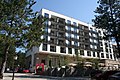
Zlatibor Spa Hotel
Zlatibor landscape
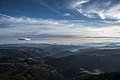
Zlatibor landscape from Ravni Tornik

Zlatibor panorama
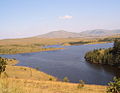
Ribnica Lake

Sirogojno

Stopića cave
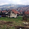
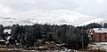
Čajetina town panorama

Čajetina Library

Uvac Monastery

St. Gabriel Church
Kriva Reka Church

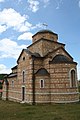
Zlatibor Church


Twin towns[]
 Herceg Novi, Montenegro
 Lefkimmi, Greece
 Nazarje, Slovenia
 Šamac, Bosnia and Herzegovina
References[]
- ^ "Municipalities of Serbia, 2006". Statistical Office of Serbia. Retrieved 2010-11-28.
- ^ "Насеља општине Чајетина" (PDF). stat.gov.rs (in Serbian). Statistical Office of Serbia. Retrieved 12 October 2019.
- ^ "2011 Census of Population, Households and Dwellings in the Republic of Serbia: Comparative Overview of the Number of Population in 1948, 1953, 1961, 1971, 1981, 1991, 2002 and 2011, Data by settlements" (PDF). Statistical Office of Republic Of Serbia, Belgrade. 2014. ISBN 978-86-6161-109-4. Retrieved 2014-06-27.
- ^ "Climate: Čajetina, Serbia". Climate-Data.org. Retrieved 15 February 2018.
- ^ "2011 Census of Population, Households and Dwellings in the Republic of Serbia" (PDF). stat.gov.rs. Statistical Office of the Republic of Serbia. Retrieved 11 January 2017.
- ^ "MUNICIPALITIES AND REGIONS OF THE REPUBLIC OF SERBIA, 2019" (PDF). stat.gov.rs. Statistical Office of the Republic of Serbia. 25 December 2019. Retrieved 28 December 2019.
External links[]
| Wikimedia Commons has media related to Čajetina. |
Municipalities and cities of Serbia | ||||||||||||
|---|---|---|---|---|---|---|---|---|---|---|---|---|
| ||||||||||||
| ||||||||||||
| ||||||||||||
| ||||||||||||
| ||||||||||||


This Zlatibor District, Serbia location article is a stub. You can help Wikipedia by . |
- Zlatibor
- Populated places in Zlatibor District
- Municipalities and cities of Šumadija and Western Serbia
- Zlatibor District geography stubs