Černá Voda
Černá Voda | |
|---|---|
Municipality | |
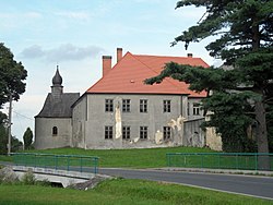 Chateau in the village | |
 Flag  Coat of arms | |
 Černá Voda | |
| Coordinates: 50°18′30″N 17°9′21″E / 50.30833°N 17.15583°ECoordinates: 50°18′30″N 17°9′21″E / 50.30833°N 17.15583°E | |
| Country | |
| Region | Olomouc |
| District | Jeseník |
| Area | |
| • Total | 9.96 km2 (3.85 sq mi) |
| Elevation | 340 m (1,120 ft) |
| Population (2006) | |
| • Total | 629 |
| • Density | 63/km2 (160/sq mi) |
| Postal code | 790 54 |
| Website | http://www.obeccernavoda.cz/ |

Černá Voda (German: Schwarzwasser, both meaning "black water") is a village and municipality (obec) in Jeseník District in the Olomouc Region of the Czech Republic.
The municipality covers an area of 9.96 square kilometres (3.85 sq mi), and has a population of 629 (as at 3 July 2006).
Černá Voda lies approximately 9 kilometres (6 mi) north of Jeseník, 80 km (50 mi) north of Olomouc, and 197 km (122 mi) east of Prague.
References[]
| Wikimedia Commons has media related to Černá Voda. |
| Authority control: National libraries |
|---|
This Olomouc Region location article is a stub. You can help Wikipedia by . |
Categories:
- Villages in Jeseník District
- Olomouc Region geography stubs