Čierny Balog
Čierny Balog | |
|---|---|
Village | |
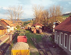 Station of the Čierny Hron Railway, a narrow gauge railway | |
 Coat of arms | |
 Čierny Balog Location of Čierny Balog in the Banská Bystrica Region | |
| Coordinates: 48°45′N 19°40′E / 48.750°N 19.667°ECoordinates: 48°45′N 19°40′E / 48.750°N 19.667°E | |
| Country | Slovakia |
| Region | Banská Bystrica |
| District | Brezno |
| First mentioned | 1545 |
| Area | |
| • Total | 147.104 km2 (56.797 sq mi) |
| Elevation | 550 m (1,800 ft) |
| Population (2018-12-31[1]) | |
| • Total | 5,081 |
| • Density | 35/km2 (89/sq mi) |
| Postal code | 976 52 |
| Area code(s) | +421-48 |
| Car plate | BR |
| Website | www.ciernybalog.sk |


Čierny Balog (until 1927 also Balog, or Čierny Hronec, in Hungarian: Feketebalog) is a municipality in Brezno District, in the Banská Bystrica Region of central Slovakia.
History[]
The village arose after 1882 (1888 mentioned as Feketebalog) by a merge of 13 villages (e.g. Balog, Krám, Dobroč, Dolina). Until 1920, it belonged to Hungary, as part of Zólyom County. It played an important role during World War II, as one of the centers of the anti-Nazi Slovak National Uprising.
Twin towns – sister cities[]
Čierny Balog is twinned with:[2]
 Týniště nad Orlicí, Czech Republic
See also[]
References[]
- ^ "Population and migration". Statistical Office of the Slovak Republic. Retrieved 16 April 2019.
- ^ "Partnerské mesto". ciernybalog.sk (in Slovak). Čierny Balog. Retrieved 9 September 2019.
Genealogical resources[]
The records for genealogical research are available at the state archive "Státný archiv in Banska Bystrica, Slovakia"
- Roman Catholic church records (births/marriages/deaths): 1656-1896 (parish A)
External links[]
- http://www.ciernybalog.sk
- http://www.e-obce.sk/obec/ciernybalog/cierny-balog.html
- http://www.muranskaplanina.com/ciernybalog.htm
- Surnames of living people in Cierny Balog
| show Municipalities of Brezno District |
|---|
| show Authority control |
|---|
This Banská Bystrica Region geography article is a stub. You can help Wikipedia by . |
Categories:
- Villages and municipalities in Brezno District
- Villages in Slovakia merged with other villages
- Banská Bystrica Region geography stubs