Lom nad Rimavicou
Lom nad Rimavicou | |
|---|---|
Village | |
 | |
 Lom nad Rimavicou Location of Lom nad Rimavicou in the Banská Bystrica Region | |
| Coordinates: 48°39′N 19°38′E / 48.650°N 19.633°ECoordinates: 48°39′N 19°38′E / 48.650°N 19.633°E | |
| Country | Slovakia |
| Region | Banská Bystrica |
| District | Brezno |
| First mentioned | 1799 |
| Area | |
| • Total | 17.404 km2 (6.720 sq mi) |
| Elevation | 938 m (3,077 ft) |
| Population (2011) | |
| • Total | 294 |
| • Density | 17/km2 (44/sq mi) |
| Postal code | 976 53 |
| Area code(s) | +421-48 |
| Car plate | BR |
| Website | www.lomnadrimavicou.ocu.sk |


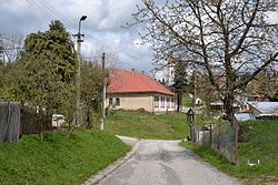
Lom nad Rimavicou is a village and municipality in Brezno District, in the Banská Bystrica Region of central Slovakia. The approximate latitude is 48.65 and longitude is 19.65. It is one of the highest located villages in Slovakia. The site was originally settled by goral highlanders. Neighbouring ski areal starts to attract the tourists.
External links[]
| hide Municipalities of Brezno District | ||
|---|---|---|
| Authority control |
|---|
This Banská Bystrica Region geography article is a stub. You can help Wikipedia by . |
Categories:
- Villages and municipalities in Brezno District
- Banská Bystrica Region geography stubs