Środa Śląska
show This article may be expanded with text translated from the corresponding article in Polish. (March 2013) Click [show] for important translation instructions. |
Środa Śląska | |
|---|---|
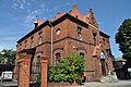
 Historical town hall at the Freedom Square (Plac Wolności) | |
 Flag  Coat of arms | |
 Środa Śląska | |
| Coordinates: 51°9′N 16°35′E / 51.150°N 16.583°E | |
| Country | |
| Voivodeship | Lower Silesian |
| County | Środa Śląska |
| Gmina | Środa Śląska |
| Government | |
| • Mayor | Adam Ruciński |
| Area | |
| • Total | 14.94 km2 (5.77 sq mi) |
| Elevation | 130 m (430 ft) |
| Population (2019-06-30[1]) | |
| • Total | 9,516 |
| • Density | 640/km2 (1,600/sq mi) |
| Time zone | UTC+1 (CET) |
| • Summer (DST) | UTC+2 (CEST) |
| Postal code | 55-300 |
| Area code(s) | +48 71 |
| Car plates | DSR |
| Website | https://en.srodaslaska.pl |

Środa Śląska [ˈɕrɔda ˈɕlɔ̃ska] (German: Neumarkt in Schlesien) is a town in the Lower Silesian Voivodeship, in south-western Poland. It is the seat of Środa Śląska County, and of the smaller administrative district (gmina) called Gmina Środa Śląska. The town lies approximately 32 kilometres (20 mi) west of the regional capital Wrocław, on the Średzka Woda creek. As of 2019, the town has a population of 9,516. It is part of the Wrocław metropolitan area.
History[]

Środa Śląska is situated in the central part of the Lower Silesia region at the main transport routes joining the east and west of Europe. The name Środa means "Wednesday", as that was the day on which the weekly market took place. Transforming it from a small commercial settlement into a center of urban character was carried out by the Polish Duke Henry the Bearded (1202–1238) whose idea was to enhance the economic and political significance of the Silesia region as a means to unify the Polish Kingdom. At around 1235, he granted the settlement a special law, based on the Magdeburg law, but adapted to the local conditions (średzkie law/Neumarkter Recht). It was a model on which many other Polish towns were later founded (including Opole, Kalisz, Wieliczka, Radom). In the 13th century the town was a regional center of salt trade.[2] Crafts and trade, including weaving, developed in the town.[2] Since the 15th century, vines were grown, as a result of which winemaking as well as brewing developed.[2]
In 1428–31 the town was devastated by the Hussites (especially devastating was the attack in 1428 when Hussites robbed the town and burnt down the monastery and church of Franciscan order). In 1526, the town was incorporated by the Habsburg monarchy. In the 16th century it was one of the regional centers of Anabaptism.[2] The town was damaged in the Thirty Years' War.[2] In 1740, the Prussian soldiers seized the town and incorporated it into the Prussian Kingdom. In 1806 it was sacked by French troops, and in 1813 by German soldiers. Together with the rest of Prussia, the town became a part of unified Germany in 1871. During World War II the Germans established there two forced labour subcamps of the Stalag VIII-A prisoner-of-war camp.[2] On 9 February 1945, the German troops withdrew from the town and it was subsequently ceded to Poland. The German population of the town fled or was forcefully expelled.
During renovation works in the 1980s, a hoard of medieval silver and gold coins and jewellery, named the Środa Treasure, was found. It is now displayed in the Regional Museum in Środa Śląska and the National Museum in Wrocław.
Sights[]
Among the heritage architecture of Środa Śląska are:
- Gothic Saint Andrew church, dating back to the 12th century
- Romanesque Nativity of Mary church, a former medieval hospital church, dating back to the 13th century
- town hall, dating back to the 14th century, now housing the Regional Museum
- medieval town walls from the 13th and 14th centuries
- Exaltation of the Holy Cross church, dating back to the 14th century
- Dominican monastery, dating back to the 18th century
- palace
- Prosecutor's office
- post office

Saint Andrew church

Nativity of Mary church

Town hall

Exaltation of the Holy Cross church

Prosecutor's office
Post office

The golden crown of the Środa treasure


Transport[]
A train station is located in the town.
Notable people[]
- Laurentius Corvinus (1465–1527), Polish scholar
- Franz Josef Kallmann (1897–1965), American psychiatrist
- Hugo von Kirchbach (1809–1887), Prussian general
- Leszek Kosedowski (born 1954), Polish boxer
- Rościsław Żerelik (born 1956), Polish historian
Twin towns – sister cities[]
See twin towns of Gmina Środa Śląska.
References[]
- ^ "Population. Size and structure and vital statistics in Poland by territorial division in 2019. As of 30th June". stat.gov.pl. Statistics Poland. 2019-10-15. Retrieved 2020-02-14.
- ^ Jump up to: a b c d e f "Środa Śląska". Encyklopedia PWN (in Polish). Retrieved 24 November 2019.
External links[]
- Municipal website
- Jewish Community in Środa Śląska on Virtual Shtetl
- Środa Śląska - Neumarkt na portalu polska-org.pl (in Polish)
| hide | ||
|---|---|---|
| Town and seat |  | |
| Villages | ||
| hide | ||
|---|---|---|
Seat: Środa Śląska | ||
| Urban-rural gmina |  | |
| Rural gminas | ||
| show Authority control |
|---|
- Cities and towns in Lower Silesian Voivodeship
- Środa Śląska County
- Province of Silesia
- Province of Lower Silesia