Tartus Governorate
Tartus Governorate
مُحافظة طرطوس | |
|---|---|
 Map of Syria with Tartus highlighted | |
| Coordinates (Tartus): 35°N 36°E / 35°N 36°ECoordinates: 35°N 36°E / 35°N 36°E | |
| Country | |
| Capital | Tartus |
| Manatiq (Districts) | 5 |
| Government | |
| • Governor | Safwan Abu Sa'adi[citation needed] |
| Area | |
| • Total | 1,892 km2 (731 sq mi) |
| Estimates range between 1,890 km² and 1,892 km² | |
| Population (2011) | |
| • Total | 797,000 |
| • Density | 420/km2 (1,100/sq mi) |
| Time zone | UTC+2 (EET) |
| • Summer (DST) | UTC+3 (EEST) |
| ISO 3166 code | SY-TA |
| Main language(s) | Arabic |

Tartus Governorate, also transliterated as Tartous Governorate, (Arabic: مُحافظة طرطوس / ALA-LC: Muḥāfaẓat Ṭarṭūs) is one of the 14 governorates of Syria. It is situated in western Syria, bordering Latakia Governorate to the north, Homs and Hama Governorates to the east, Lebanon to the south, and the Mediterranean Sea to the west. It is one of the few governorates in Syria that has an Alawite majority. Sources list the area as 1,890 km²[1] or 1,892 km²,[2] with its capital being Tartus.
History[]
The governorate was historically part of the Alawite State, which existed from 1920–1936.[3]
It was formerly part of Latakia governorate, but was split off circa 1972.[1]
The region has been relatively peaceful during the Syrian civil war, being a generally pro-Assad region that had remained under government control. However in 2013 massacres against Sunni Muslims occurred in Bayda and Baniyas,[4][5] and a suicide bombing claimed by Islamic State occurred in Tartus in May 2016.[6] Tartus is home to a major Russian naval base.[citation needed]
Archeological sites[]
- Al-Kahf Castle - Isma'ili castle
- Aleika Castle - Isma'ili castle
- Amrit - Phoenician city
- Chastel Rouge (Qal’at Yahmur) - Crusader castle
- Hosn Suleiman
- Margat - Crusader castle
- Tell Kazel - Bronze age site (possibly the ancient city of Sumur)
Geography[]
Tartus comprises roughly half of Syria's Mediterranean coastline; offshore lie five small islands, the largest of which is Arwad.[7] Inland the terrain is mountainous, comprising a section of the Syrian Coastal Mountain Range (Nusayriyah Mountains).[8] The Nahr al-Kabir river forms the border with Lebanon to the south.[9]
Settlements[]
Tartus is the regional capital; other major settlements include Al-Hamidiyah, Al Qadmus, Al-Sawda, Ayn ash Shams, Baniyas, Qusaybah and Safita.
Districts[]
The governorate is divided into five districts (manatiq). The districts are further divided into 27 sub-districts (nawahi):[citation needed]
|
|
Demographics[]
As per the 2004 Syrian census the population was 701,400.[1] A 2011 UNOCHA estimate put the population at 797,000, though this has likely changed since the start of the war.[10]
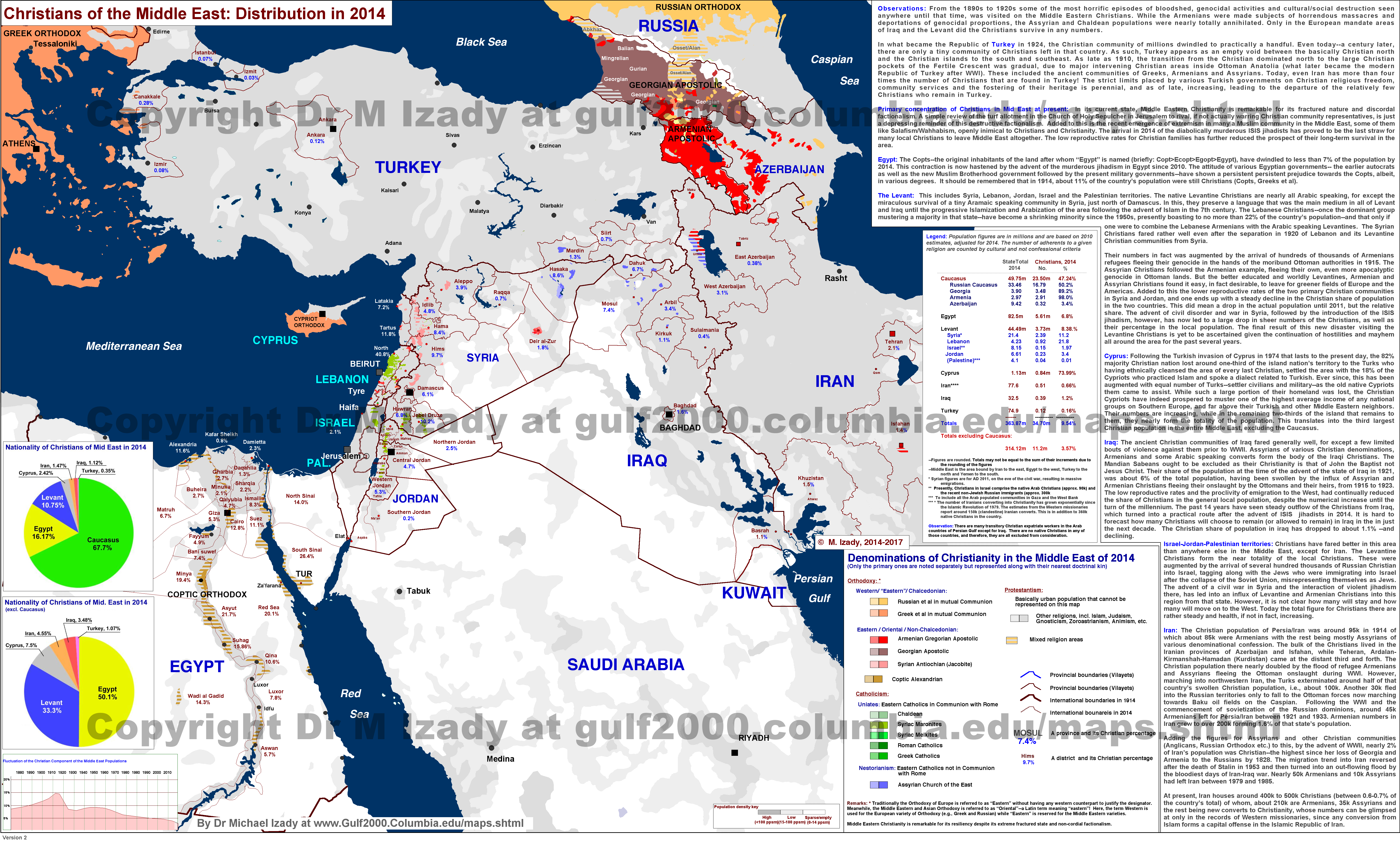
The majority at 72% are Alawites, 7% Sunni Muslim, 8% Ismaili and 13% Christian,[11] though according to recent estimations by Dr. Michael Izady Christians form 11.8% of the population in the governorate.[12] There is a small Cretan Greek community concentrated in Al-Hamidiyah, the descendants of refugees who fled the Greco-Turkish War of 1897.[13]
Gallery[]
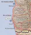
Map of Tartus governorate

Safita

Mountains near Kaff al-Jaa
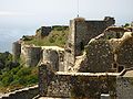
Margat Castle

Al Kafrun
Arwad Castle


References[]
- ^ Jump up to: a b c "Syria Provinces". www.statoids.com.
- ^ "Syria: Governorates, Major Cities & Localities - Population Statistics, Maps, Charts, Weather and Web Information". www.citypopulation.de.
- ^ Longrigg, Stephen Hemsley. "Syria and Lebanon Under French Mandate." London: Oxford University Press, 1958.
- ^ Peter Beaumont. "The Guardian, 4 May 2013". Guardian. Retrieved 2014-01-06.
- ^ Nebehay, Stephanie (2013-09-11). "Syrian forces responsible for Banias massacres: U.N. report". News.yahoo.com. Retrieved 2014-01-06.
- ^ "Syria bombings claimed by ISIS kill 148 at hospital, bus station". 23 May 2016. Retrieved 26 May 2016.
- ^ "Arwad, Fortress at Sea". Aramco World. Retrieved 3 November 2018.
- ^ Federal Research Division, Library of Congress (2005) "Country Profile: Syria" page 5
- ^ United Nations Economic and Social Commission for Western Asia et al., "Nahr el Kabir Basin", Inventory of Shared Water Resources in Western Asia 8 PDF
- ^ Syrian Arab Republic - Governorates profile (PDF), UNOCHA, June 2014, retrieved 20 March 2020
- ^ Hussain Ibrahim Qutrib (2016), "Useful Syria" and Demographic Changes in Syria (PDF), King Faisal Center for Research and Islamic Studies, retrieved 20 March 2020
- ^ http://gulf2000.columbia.edu/images/maps/Christians_Middle_East_2014_lg.png
- ^ Greek-Speaking Enclaves of Lebanon and Syria by Roula Tsokalidou. Proceedings II Simposio Internacional Bilingüismo. Retrieved 4 December 2006
External links[]
- etartus The First Complete website for Tartus news and services

| Authority control |
|
|---|
- Tartus Governorate
- Governorates of Syria