1948 Pacific typhoon season

From Wikipedia, the free encyclopedia
1948 Pacific typhoon season
1948 Pacific typhoon season summary.jpg
Season summary map
Seasonal boundaries
First system formedJanuary 11, 1948
Last system dissipatedDecember 16, 1948
Strongest storm
NameLibby
 • Maximum winds230 km/h (145 mph)
(1-minute sustained)
 • Lowest pressure924 hPa (mbar)
Seasonal statistics
Total storms26
Typhoons15
Super typhoons1 (unofficial)
Total fatalitiesUnknown
Total damageUnknown
Related articles
Pacific typhoon seasons
1946, 1947, 1948, 1949, 1950

The 1948 Pacific typhoon season is an average season. Ihas no official bounds; it ran year-round in 1948, but most tropical cyclones tend to form in the northwestern Pacific Ocean between June and December. These dates conventionally delimit the period of each year when most tropical cyclones form in the northwestern Pacific Ocean.

The scope of this article is limited to the Pacific Ocean, north of the equator and west of the International Date Line. Storms that form east of the date line and north of the equator are called hurricanes; see 1948 Pacific hurricane season. At the time, tropical storms that formed within this region of the western Pacific were identified and named by the United States Armed Services, and these names are taken from the list that USAS publicly adopted before the 1945 season started.[1][2]

Season summary[]

Saffir–Simpson hurricane wind scale

Storms[]

Typhoon Karen[]

Typhoon (JMA)
Category 4 super typhoon (SSHWS)
Typhoon Karen's Weather map on January 16, 1948.png Karen 1948 track.png
DurationJanuary 11 – January 19
Peak intensity240 km/h (150 mph) (1-min)  936 hPa (27.64 inHg) hPa (mbar)

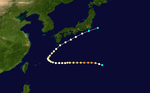
Typhoon Karen, the strongest cyclone of the season and one of the earliest recorded super typhoons, developed on January 11, well west of the Philippines. It curved westward while slowly intensifying. After a prolonged period of slow intensification, the tropical cyclone began to rapidly strengthen. It became a super typhoon on January 16. Shortly after, it weakened and dissipated on January 19.

It struck Yap on January 14, damaging and destroying establishments and houses on the island.[3] It also wrecked the roofs of some U.S. warehouses and buildings, and downed power lines.[3] A food warehouse were washed out; however, some food supplies survived.[3]

After the typhoon, the navy transported some relief supplies to the populated island.[3] No deaths were reported.[3]

Typhoon Lana[]

Typhoon (JMA)
Category 1 typhoon (SSHWS)
Typhoon Lana's Weather map on May 19, 1948.png Lana 1948 track.png
DurationMay 16 – May 20
Peak intensity150 km/h (90 mph) (1-min)  971 hPa (mbar)

Typhoon Lana, the second system of the season, formed on May 16, west of the Philippines. It moved to the north-northeast while intensifying, reaching its peak intensity somewhere on May 18 and 19. It then weakened, until it was last noted on May 20 as it merged with a cold front.

Warnings were issued for Yap, Palau, Guam and Ulithi in preparations for the storm.[4] All ships in these islands were instructed to escape to Sangley Point due to the approaching typhoon.[5]

A plane in Guam encountered the strength of the typhoon; however, it escaped its fury.[5] Eighteen individuals were reported dead in Yap when their canoe sank during the storm.[5] The damage, however, was minimal.[5]

Typhoon Mabel[]

Typhoon (JMA)
Category 1 typhoon (SSHWS)
Typhoon Mabel's Weather map on May 31, 1948.png Mabel 1948 track.png
DurationMay 29 – June 2
Peak intensity150 km/h (90 mph) (1-min)  964 hPa (mbar)

Typhoon Nadine[]

Typhoon (JMA)
Tropical storm (SSHWS)
Nadine 1948 track.png 
DurationJune 9 – June 11
Peak intensity110 km/h (70 mph) (1-min)  986 hPa (mbar)

Tropical Storm Ophelia[]

Tropical storm (SSHWS)
Ophelia 1948 track.png 
DurationJune 10 – June 11
Peak intensity75 km/h (45 mph) (1-min)  991 hPa (mbar)

Ophelia formed on June 10 in the South China Sea. It moved west and struck southern China. It dissipated the next day, without attaining maximum sustained winds any higher than 45 mph.

Typhoon Pearl[]

Typhoon (JMA)
Category 2 typhoon (SSHWS)
Pearl 1948 track.png 
DurationJuly 1 – July 8
Peak intensity165 km/h (105 mph) (1-min)  960 hPa (mbar)

Typhoon Rose[]

Typhoon (JMA)
Category 1 typhoon (SSHWS)
Rose 1948 track.png 
DurationJuly 23 – July 28
Peak intensity130 km/h (80 mph) (1-min)  981 hPa (mbar)

Typhoon Bertha[]

Typhoon (JMA)
Category 1 typhoon (SSHWS)
Bertha 1948 track.png 
DurationAugust 4 – August 6
Peak intensity130 km/h (80 mph) (1-min)  976 hPa (mbar)

Tropical Storm Chris[]

Tropical storm (SSHWS)
Chris 1948 track.png 
DurationAugust 8 – August 14
Peak intensity95 km/h (60 mph) (1-min)  988 hPa (mbar)

Typhoon Dolores–Eunice[]

Typhoon (JMA)
Tropical storm (SSHWS)
Dolores 1948 track.png 
DurationAugust 10 – August 14
Peak intensity85 km/h (50 mph) (1-min)  990 hPa (mbar)

Tropical Storm Dolores was tracked by the Air Weather Service located on Guam. At one point, a tropical storm was identified and assigned the name Eunice. Post analysis showed that Tropical Storm Dolores was north of the forecast location and actually the system assigned the name Eunice.[6]

Typhoon Flo[]

Typhoon (JMA)
Tropical storm (SSHWS)
Flo 1948 track.png 
DurationAugust 20 – August 23
Peak intensity95 km/h (60 mph) (1-min)  990 hPa (mbar)

Typhoon Gestrude[]

Typhoon (JMA)
Category 2 typhoon (SSHWS)
Gestrude 1948 track.png 
DurationAugust 27 – September 4
Peak intensity155 km/h (100 mph) (1-min)  976 hPa (mbar)

Typhoon Hazel[]

Typhoon (JMA)
Category 1 typhoon (SSHWS)
Hazel 1948 track.png 
DurationSeptember 2 – September 7
Peak intensity150 km/h (90 mph) (1-min)  966 hPa (mbar)

Typhoon Ione[]

Typhoon (JMA)
Category 4 typhoon (SSHWS)
Ione 1948 track.png 
DurationSeptember 11 – September 17
Peak intensity220 km/h (140 mph) (1-min)  925 hPa (mbar)

A Tropical Storm formed on September 11 and soon turned toward Japan as it gained strength. Ione soon reached category 4 intensity on September 14. Ione then began to lose strength and became a category 1 on September 16. Then, Ione struck Japan in that day killing 838 people.[7] Ione further weakened and became a Tropical Storm on the 17th. Ione then dissipated.

Typhoon Jackie[]

Typhoon (JMA)
Category 1 typhoon (SSHWS)
Jackie 1948 track.png 
DurationSeptember 11 – September 18
Peak intensity150 km/h (90 mph) (1-min)  962 hPa (mbar)

Typhoon Kit[]

Typhoon (JMA)
Tropical storm (SSHWS)
Kit 1948 track.png 
DurationSeptember 24 – September 28
Peak intensity110 km/h (70 mph) (1-min)  989 hPa (mbar)

Typhoon Libby[]

Typhoon (JMA)
Category 4 typhoon (SSHWS)
Libby 1948 track.png 
DurationSeptember 29 – October 7
Peak intensity230 km/h (145 mph) (1-min)  924 hPa (mbar)

Typhoon Martha[]

Typhoon (JMA)
Category 3 typhoon (SSHWS)
Martha 1948 track.png 
DurationOctober 4 – October 8
Peak intensity185 km/h (115 mph) (1-min)  943 hPa (mbar)

Typhoon Norma[]

Typhoon (JMA)
Tropical storm (SSHWS)
Norma 1948 track.png 
DurationOctober 11 – October 12
Peak intensity95 km/h (60 mph) (1-min)  992 hPa (mbar)

Tropical Storm Olga[]

Tropical storm (SSHWS)
Olga 1948 track.png 
DurationOctober 16 – October 19
Peak intensity100 km/h (65 mph) (1-min)  994 hPa (mbar)

Typhoon Pat[]

Typhoon (JMA)
Tropical storm (SSHWS)
Pat 1948 track.png 
DurationOctober 27 – October 31
Peak intensity110 km/h (70 mph) (1-min)  987 hPa (mbar)

Typhoon Rita[]

Typhoon (JMA)
Category 3 typhoon (SSHWS)
Rita 1948 track.png 
DurationNovember 4 – November 11
Peak intensity185 km/h (115 mph) (1-min)  957 hPa (mbar)

Typhoon Agnes[]

Typhoon (JMA)
Category 2 typhoon (SSHWS)
Agnes 1948 track.png 
DurationNovember 13 – November 20
Peak intensity175 km/h (110 mph) (1-min)  939 hPa (mbar)

Tropical Storm 24W[]

Tropical storm (SSHWS)
24W 1948 track.png 
DurationNovember 29 – December 2
Peak intensity85 km/h (50 mph) (1-min)  997 hPa (mbar)

Typhoon Beverly[]

Typhoon (JMA)
Category 1 typhoon (SSHWS)
Beverly 1948 track.png 
DurationDecember 2 – December 10
Peak intensity150 km/h (90 mph) (1-min)  947 hPa (mbar)

Tropical Storm 26W[]

Tropical storm (SSHWS)
26W 1948 track.png 
DurationDecember 12 – December 16
Peak intensity75 km/h (45 mph) (1-min)  997 hPa (mbar)

Other Systems[]

Between 23 July and 4 August, the name Annabell was assigned to a North West Pacific system. The Air Weather Service issued a bulletin issued and tropical cyclone named on what was later determined to be "trough activity"

Storm names[]

Tropical storm names were assigned by the Joint Typhoon Warning Center since 1945.

Karen Lana Mabel Nadine Ophelia Pearl Rose Annabell Bertha
Chris Dolores Eunice Flo Gestrude Hazel Ione Jackie Kit
Libby Martha Norma Olga Pat Rita Agnes Beverly

See also[]

References[]

  1. ^ Landsea, Christopher W; Dorst, Neal M (June 1, 2014). "Subject: Tropical Cyclone Names: B1) How are tropical cyclones named?". Tropical Cyclone Frequently Asked Question. United States National Oceanic and Atmospheric Administration's Hurricane Research Division. Archived from the original on March 29, 2015.
  2. ^ Cry, George (July 1958). Bristow, Gerald C (ed.). "Naming hurricanes and typhoons". Mariners Weather Log. 2 (4): 109. hdl:2027/uc1.b3876059. ISSN 0025-3367. OCLC 648466886.
  3. ^ a b c d e "Yap Typhoon Veers North". The Lincoln Star. 1948-01-16. p. 5. Retrieved 2021-04-14.
  4. ^ "Typhoon Named Lana Moves Towards Guam And The Philippines". Rushville Republican. 1948-05-17. p. 3. Retrieved 2021-04-14.
  5. ^ a b c d "18 Islanders Die As Typhoon Roars". The Tampa Times. 1948-05-17. p. 1. Retrieved 2021-04-14.
  6. ^ Air Weather Service "Report on the Typhoon Post-Analysis Program (1948-1949) of the North Pacific Typhoon Warning System"
  7. ^ Translate.google.com

External links[]


Retrieved from ""