1950 Pacific typhoon season

From Wikipedia, the free encyclopedia
1950 Pacific typhoon season
1950 Pacific typhoon season summary.png
Season summary map
Seasonal boundaries
First system formedApril 12, 1950
Last system dissipatedJanuary 1, 1951
Strongest storm
NameClara
 • Maximum winds230 km/h (145 mph)
(1-minute sustained)
 • Lowest pressure899 hPa (mbar)
Seasonal statistics
Total storms18
Typhoons12
Super typhoons1 (unofficial)
Total fatalities544 total
Total damageUnknown
Related articles
Pacific typhoon seasons
1948, 1949, 1950, 1951, 1952

The 1950 Pacific typhoon season has no official bounds; it ran year-round in 1950, but most tropical cyclones tend to form in the northwestern Pacific Ocean between June and December. These dates conventionally delimit the period of each year when most tropical cyclones form in the northwestern Pacific Ocean.

The scope of this article is limited to the Pacific Ocean, north of the equator and west of the international date line. Storms that form east of the date line and north of the equator are called hurricanes; see 1950 Pacific hurricane season. This would be the first season that Fleet Weather Center in Guam, predecessor agency to Joint Typhoon Warning Center, would take most of the responsibility in the basin, including naming the storms.[1] Before this season, the storms are identified and named by the United States Armed Services, and these names are taken from the list that USAS publicly adopted before the 1945 season started.[2][3]

Systems[]

Severe Tropical Storm One[]

Severe tropical storm (CMA)
Severe Tropical Storm 01 analysis 14 Apr 1950 0000Z.png CMA TS 1 1950 track.png
DurationApril 12 – April 15
Peak intensity110 km/h (70 mph) (10-min)  984 hPa (mbar)

Typhoon Doris[]

Typhoon (JMA)
Category 4 super typhoon (SSHWS)
Typhoon Doris analysis 11 May 1950 1200Z.png Doris 1950 track.png
DurationMay 6 – May 14
Peak intensity240 km/h (150 mph) (1-min)  922 hPa (mbar)

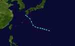
Doris was an intense category 4 Super Typhoon that mostly remained out to sea. It formed on May 6, peaked as a strong category 4, and then dissipated on May 14. Doris reached a very low pressure of 922 mbar.

Tropical Storm 02W[]

Tropical storm (JMA)
Tropical storm (SSHWS)
Tropical Storm 02W analysis 6 June 1950 1200Z.png 2-W 1950 track.png
DurationJune 5 – June 9
Peak intensity65 km/h (40 mph) (1-min)  997 hPa (mbar)

This storm impacted Taiwan.

Typhoon Elsie[]

Typhoon (JMA)
Category 1 typhoon (SSHWS)
Typhoon Elsie analysis 23 Jun 1950 1200Z.png Elsie 1950 track.png
DurationJune 22 – June 24
Peak intensity140 km/h (85 mph) (1-min)  981 hPa (mbar)

CMA Severe Tropical Storm Six[]

Severe tropical storm (CMA)
CMA TS 6 1950 track.png 
DurationJuly 12 – July 15
Peak intensity95 km/h (60 mph) (10-min)  990 hPa (mbar)

Typhoon Flossie[]

Typhoon (JMA)
Tropical storm (SSHWS)
Flossie 1950 track.png 
DurationJuly 15 – July 19
Peak intensity110 km/h (70 mph) (1-min)  993 hPa (mbar)

Typhoon Grace[]

Typhoon (JMA)
Category 1 typhoon (SSHWS)
Grace 1950 track.png 
DurationJuly 15 – July 22
Peak intensity130 km/h (80 mph) (1-min)  981 hPa (mbar)

Typhoon Grace impacted Korea and Japan.

Tropical Storm Helene[]

Tropical storm (JMA)
Tropical storm (SSHWS)
Helene 1950 track.png 
DurationJuly 24 – August 1
Peak intensity95 km/h (60 mph) (1-min)  990 hPa (mbar)

This storm stalled near Japan and accelerated towards China.

Tropical Storm Thirteen[]

Tropical storm (CMA)
CMA TS 13 1950 track.png 
DurationAugust 2 – August 4
Peak intensity75 km/h (45 mph) (10-min)  992 hPa (mbar)

Tropical Storm Fifteen[]

Tropical storm (CMA)
CMA TS 15 1950 track.png 
DurationAugust 3 – August 4
Peak intensity75 km/h (45 mph) (10-min)  998 hPa (mbar)

Tropical Storm Sixteen[]

Tropical storm (JMA)
CMA TS 16 1950 track.png 
DurationAugust 4 – August 6
Peak intensity75 km/h (45 mph) (10-min)  996 hPa (mbar)

This storm was the third and last storm consecutively to make landfall on Japan.

Typhoon Ida[]

Typhoon (JMA)
Category 1 typhoon (SSHWS)
Ida 1950 track.png 
DurationAugust 9 – August 22
Peak intensity140 km/h (85 mph) (1-min)  973 hPa (mbar)

Tropical Depression Twenty[]

Tropical depression (JMA)
CMA TS 20 1950 track.png 
DurationAugust 10 – August 14
Peak intensity95 km/h (60 mph) (10-min)  990 hPa (mbar)

This storm impacted Japan and South Korea. This storm also occurred in the Korean War, where Korean soldiers were battling in South Korea during the storm's impact on land.

Severe Tropical Storm Twenty-one[]

Severe tropical storm (CMA)
CMA TS 21 1950 track.png 
DurationAugust 11 – August 14
Peak intensity110 km/h (70 mph) (10-min)  980 hPa (mbar)

Severe Tropical Storm Twenty-one was a severe tropical storm that remained in open waters.

Severe Tropical Storm Twenty-three[]

Tropical storm (JMA)
CMA TS 23 1950 track.png 
DurationAugust 14 – August 22
Peak intensity110 km/h (70 mph) (10-min)  990 hPa (mbar)

Severe Tropical Storm Twenty-Three tracked through Japan.

Typhoon Jane[]

Typhoon (JMA)
Category 3 typhoon (SSHWS)
Typhoon Jane 1950 Scan10003.JPG Jane 1950 track.png
DurationAugust 29 – September 3
Peak intensity185 km/h (115 mph) (1-min)  943 hPa (mbar)

Typhoon Jane struck the island of Shikoku in Japan on 3 September. Resulting flooding and landslides killed 539 people. [1]

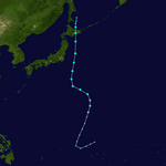
In late August, a depression formed and quickly intensified into a tropical storm and was given the name Jane. The storm drifted west-northwestward and intensified into a typhoon. Jane gradually curved to the north and intensified to a category 2 typhoon. Jane shortly reached category 3 status and peak intensity at 185 km/h (115 mph). The typhoon accelerated to the north-northeast and weakened to a category 2 storm and made landfall in the modern-day Osaka-Kobe-Kyoto area. Jane crossed Kyoto Prefecture and weakened to a tropical storm and crossed the Noto Peninsula and reentered the Sea of Japan and passed just west of Sado Island. The storm struck eastern Aomori Prefecture and crossed the and made a final landfall on the south coast of Hokkaido Prefecture. Jane crossed Hokkaido and dissipated south of the Kuril Islands.

Typhoon Kezia[]

Typhoon (JMA)
Category 3 typhoon (SSHWS)
Kezia 1950 track.png 
DurationSeptember 4 – September 14
Peak intensity185 km/h (115 mph) (1-min)  945 hPa (mbar)

On September 13 Typhoon Kezia hit part of the fleet off Kyushu.

P-51 Mustangs belonging to No. 77 Squadron RAAF were grounded at Iwakuni because of the typhoon on September 13 and 14.[4]

There was great damage in western Japan. In Japan, 30 dead, 19 missing people, 35 injured. The total damage and breakage of the house is 4,836. There are 121,1924 inundated houses. In the Itsukushima Shrine the building was damaged, the Kintai Bridge was lost.[5]

Severe Tropical Storm Twenty-six[]

Severe tropical storm (CMA)
CMA TS 26 1950 track.png 
DurationSeptember 6 – September 8
Peak intensity95 km/h (60 mph) (10-min)  995 hPa (mbar)

This storm tracked through Vietnam and Laos.

Tropical Storm Lucretia-Nancy[]

Tropical storm (JMA)
Tropical storm (SSHWS)
Lucretia-Nancy 1950 track.png 
DurationSeptember 14 – September 19
Peak intensity100 km/h (65 mph) (1-min)  987 hPa (mbar)

Typhoon Missatha[]

Unknown strength tropical cyclone
Category 1 typhoon (SSHWS)
Missatha 1950 track.png 
DurationSeptember 13 – September 18
Peak intensity130 km/h (80 mph) (1-min)  984 hPa (mbar)

Typhoon Missatha paralleled Japan.

Typhoon Ossia[]

Typhoon (JMA)
Category 3 typhoon (SSHWS)
Ossia 1950 track.png 
DurationSeptember 27 – October 6
Peak intensity185 km/h (115 mph) (1-min)  966 hPa (mbar)

Typhoon Ossia impacted the Philippines.

Typhoon Petie[]

Typhoon (JMA)
Category 2 typhoon (SSHWS)
Petie 1950 track.png 
DurationOctober 18 – October 24
Peak intensity165 km/h (105 mph) (1-min)  978 hPa (mbar)

Severe Tropical Storm Thirty-five[]

Severe tropical storm (CMA)
CMA TS 35 1950 track.png 
DurationOctober 26 – October 31
Peak intensity95 km/h (60 mph) (10-min)  995 hPa (mbar)

Typhoon Ruby[]

Typhoon (JMA)
Category 3 typhoon (SSHWS)
Ruby 1950 track.png 
DurationOctober 27 – October 31
Peak intensity185 km/h (115 mph) (1-min)  918 hPa (mbar)

Typhoon Billie[]

Typhoon (JMA)
Category 1 typhoon (SSHWS)
Billie 1950 track.png 
DurationNovember 4 – November 9
Peak intensity150 km/h (90 mph) (1-min)  985 hPa (mbar)

Typhoon Clara[]

Typhoon (JMA)
Category 4 typhoon (SSHWS)
Clara 1950 track.png 
DurationNovember 4 – November 12
Peak intensity230 km/h (145 mph) (1-min)  899 hPa (mbar)

Tropical Storm Delilah[]

Tropical storm (JMA)
Tropical storm (SSHWS)
Delliah 1950 track.png 
DurationNovember 19 – November 25
Peak intensity110 km/h (70 mph) (1-min)  989 hPa (mbar)

This Tropical Storm affected the Philippines.

Severe Tropical Storm Ellen[]

Severe tropical storm (CMA)
Ellen 1950 track.png 
DurationDecember 11 – December 13
Peak intensity110 km/h (70 mph) (10-min)  990 hPa (mbar)

Ellen remained at sea, without impacting land.

Typhoon Fran[]

Typhoon (JMA)
Category 1 typhoon (SSHWS)
Fran 1950 track.png 
DurationDecember 26 – January 1
Peak intensity150 km/h (90 mph) (1-min)  980 hPa (mbar)

Typhoon Fran was a late season storm that struck the northern Philippines killing 5 people.[6]

Storm names[]

20 Names were used during the season, the first being Doris and the last was Fran

1. Doris 11. Nancy
2. Elsie 12. Ossia
3. Flossie 13. Pete
4. Grace 14. Ruby
5. Helene 15. Anita
6. Ida 16. Billie
7. Jane 17. Clara
8. Kezia 18. Delilah
9. Lucretia 19. Ellen
10. Missatha 20. Fran

Names Decommissioned[]

After the season 8 names were decommissioned by the WMO, namely Delilah, Helene, Jane, Kezia, Lucretia, Missatha, Ossia, and Petie. They are subsequently replaced with Dot, Helen, June, Kathy, Lorna, Marie, Olga, and Pamela.

See also[]

References[]

  1. ^ Joint Typhoon Warning Center 50th Anniversary May 1959 – May 2009. April 29, 2009. Retrieved November 14, 2014.
  2. ^ Landsea, Christopher W; Dorst, Neal M (June 1, 2014). "Subject: Tropical Cyclone Names: B1) How are tropical cyclones named?". Tropical Cyclone Frequently Asked Question. United States National Oceanic and Atmospheric Administration's Hurricane Research Division. Archived from the original on March 29, 2015.
  3. ^ Cry, George (July 1958). Bristow, Gerald C (ed.). "Naming hurricanes and typhoons". Mariners Weather Log. 2 (4): 109. hdl:2027/uc1.b3876059. ISSN 0025-3367. OCLC 648466886.
  4. ^ "RAAF Form A.50 - No. 77 Squadron, RAAF - September 1950". AviationHeritage.org. Retrieved 28 June 2016.
  5. ^ "錦帯橋の歴史". 岩国市観光振興課. 2012-09-21. Archived from the original on 2012-03-12. Retrieved 2019-01-15.
  6. ^ Pagasa - Dost - Dost Service Institutes

External links[]

Retrieved from ""