1959 Pacific typhoon season
| 1959 Pacific typhoon season | |
|---|---|
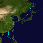
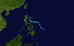
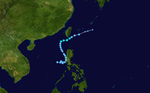
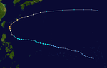
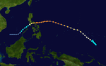
 Season summary map | |
| Seasonal boundaries | |
| First system formed | February 27, 1959 |
| Last system dissipated | January 2, 1960 |
| Strongest storm | |
| Name | Joan |
| • Maximum winds | 315 km/h (195 mph) (1-minute sustained) |
| • Lowest pressure | 885 hPa (mbar) |
| Seasonal statistics | |
| Total depressions | 33 |
| Total storms | 25 |
| Typhoons | 18 |
| Super typhoons | 8 (unofficial) |
| Total fatalities | > 8,557 |
| Total damage | > $755 million (1959 USD) |
| Related articles | |
The 1959 Pacific typhoon season was regarded as one of the most devastating years for Pacific typhoons on record, with China, Japan and South Korea sustaining catastrophic losses.[1]
The scope of this article is limited to the Pacific Ocean, north of the equator and west of the International Date Line. Storms that form east of the Date Line and north of the equator are called hurricanes; see 1959 Pacific hurricane season. All typhoons were assigned a name and number. Tropical storms and tropical depressions formed in the entire west Pacific basin were assigned a name and number by the Joint Typhoon Warning Center, but the latter was not added if no reconnaissance missions were assigned. Systems handled by the responsibility of the USWB and FWB featured no number.
The 1959 Pacific typhoon season featured 24 tropical cyclones, though operationally 59 total areas of investigation were classified by the Joint Typhoon Warning Center (JTWC);[2] three systems were handled by the responsibility of FWB at Pearl Harbor and the USWB at Honolulu. Three systems were questionable due to lack of reconnaissance aircraft use. In total, the season featured 65 tropical cyclones and areas of investigation operationally, including central Pacific Hurricane Patsy, which was operationally believed to have crossed the International Date Line into the western Pacific. The first annual tropical cyclone report for the western North Pacific Ocean was issued by the agency.[2]
Season summary[]

Of the 33 tropical cyclones and 65 total areas of investigation, 18 storms attained typhoon status, which was below the yearly average of 19.[2] At least nine other tropical systems never exceeded tropical storm intensity operationally. Most of the systems were noted to have developed within the typical spawning grounds for typhoons originating from easterly waves within the Intertropical Convergence Zone; the exceptions were Ellen and Georgia which developed from cold-core troughs extending southward into the tropical latitudes. Of the 18 typhoons that formed, five were first detected within 300 miles (500 km) of the island of Guam. Three of the typhoons developed at a slow rate, while three others rapidly intensified to typhoon status within hours. Only four typhoons were small in diameter, while at least three typhoons developed to large sizes and became the dominant tropical features during the season. Two of the typhoons — Joan and Vera — featured sea-level pressures below 900 millibars and were the most intense tropical cyclones during the season, each featuring winds of 190 mph (305 km/h) or greater.[3] Of the total number of typhoons, 215 reconnaissance missions were flown into the storms, including 3,799 observations and 391 total fixes. The average track error for each advisory for storms during the season was 63.9 miles (102.8 km) for 12-hour forecasts and 301.6 miles (485.4 km) for 48-hour forecasts.[2]
Systems[]
Tropical Storm Ruby[]
| Tropical storm (JMA) | |
| Tropical storm (SSHWS) | |
 | |
| Duration | February 27 – March 1 |
|---|---|
| Peak intensity | 95 km/h (60 mph) (1-min) 998 hPa (mbar) |
The first tropical storm of the season was detected by reconnaissance aircraft on February 27 about 300 miles (480 km) south of Yap with winds of 60 miles per hour (97 km/h).[3] Moving erratically westward, Ruby maintained intensity until it passed 90 miles (140 km) south of Palau on February 28, when it began to weaken and move to the west-northwest. Ruby weakened to below tropical storm intensity on March 1 and then turned to the southwest. It dissipated later on the same day 300 miles (480 km) east of Mindanao. Ruby did not affect any major land masses.[3]
Tropical Storm Sally[]
| Tropical storm (JMA) | |
| Tropical storm (SSHWS) | |
 | |
| Duration | March 4 – March 13 |
|---|---|
| Peak intensity | 100 km/h (65 mph) (1-min) 990 hPa (mbar) |
Three days after Ruby dissipated, the second tropical cyclone of the season was detected 200 miles (320 km) southeast of Majuro in the Marshall Islands with winds of 65 miles per hour (105 km/h)[3] After drifting northwest, Sally moved to the southwest on March 5 and then began to move westward, with its winds fluctuating to 50 miles per hour (80 km/h). Sally soon restrengthened on March 6, reaching a secondary peak of 60 miles per hour (97 km/h), and maintained its intensity for 18 hours as it moved steadily westward. After weakening to 45 miles per hour (72 km/h) on March 8, Sally briefly jogged to the west-northwest on March 9, and it began to re-intensify as it turned back to the west, quickly reaching its third peak of 60 miles per hour (97 km/h) on March 10.[3] Sally slowly weakened as it turned to the northwest and slowed in forward speed, with its winds decreasing to 45 miles per hour (72 km/h) on March 11. After briefly restrengthening to 60 miles per hour (97 km/h) on March 12, Sally turned to the west and quickly weakened to a tropical depression. The depression briefly turned to the west-southwest and dissipated on March 13 300 miles (480 km) east of Mindanao.[3]
Typhoon Tilda[]
| Typhoon (JMA) | |
| Category 4-equivalent typhoon (SSHWS) | |
 | |
| Duration | April 14 – April 23 |
|---|---|
| Peak intensity | 230 km/h (145 mph) (1-min) 930 hPa (mbar) |
One month after Sally dissipated, the first typhoon of the season formed from a closed cyclonic circulation 300 miles (480 km) south of Chuuk. The circulation drifted westward, and reports from the surface showed intensification. On April 14 a reconnaissance aircraft mission estimated winds of tropical storm force, and the third tropical storm of the season was named Tilda.[2] Tilda slowly moved northwest on April 15 as it intensified into a typhoon.[3] Tilda then moved generally to the northwest with minor fluctuations on April 16 and on the following day before turning northward on April 18, when it rapidly intensified. Tilda attained its peak intensity of 145 mph (233 km/h) 400 miles (640 km) west of Guam on April 19,[2] and it slowly weakened as it turned north-northeast and decreased in forward speed. The typhoon became quasi-stationary for 30 hours on April 20, weakening to a minimal typhoon in the process by the next day. After drifting under weak steering currents, Tilda accelerated to the north-northeast on April 22 and weakened to a tropical storm. Tilda dissipated on April 23 as it merged with the upper-level westerlies 130 miles (210 km) southwest of Iwo Jima.[3] Thirty-seven warnings for Tilda were issued by the Joint Typhoon Warning Center over the course of seven days. Tilda caused no damage or direct deaths.[2]
Tropical Depression Violet[]
| Tropical depression (JMA) | |
| Tropical depression (SSHWS) | |
 | |
| Duration | June 28 – June 29 |
|---|---|
| Peak intensity | 45 km/h (30 mph) (1-min) 1001 hPa (mbar) |
Tropical Depression Violet existed offshore Vietnam from June 28 to June 29.
Tropical Storm Wilda[]
| Tropical storm (JMA) | |
| Tropical storm (SSHWS) | |
 | |
| Duration | July 4 – July 8 |
|---|---|
| Peak intensity | 65 km/h (40 mph) (1-min) 1000 hPa (mbar) |
After two months of inactivity, a tropical depression formed on July 4 in the South China Sea 480 miles (770 km) west of Luzon. After briefly drifting northeast, the depression moved erratically northward on July 5, and it made landfall on mainland China east of Hong Kong on July 6. The depression quickly dissipated after moving inland.[3] Operationally the system was classified as a tropical storm under the name Wilda, but post-analysis determined the tropical cyclone never attained winds of 39 mph (63 km/h) or greater. No reconnaissance aircraft investigated the system, which was one of only three disturbances not monitored during the season.[2]
Tropical Depression Anita[]
| Tropical depression (JMA) | |
| Tropical depression (SSHWS) | |
 | |
| Duration | July 4 – July 6 |
|---|---|
| Peak intensity | 55 km/h (35 mph) (1-min) |
Tropical Depression Anita existed in the vicinity of the Federated States of Micronesia from July 4 to July 6.
Typhoon Billie[]
| Typhoon (JMA) | |
| Category 2-equivalent typhoon (SSHWS) | |
  | |
| Duration | July 12 – July 18 |
|---|---|
| Peak intensity | 165 km/h (105 mph) (1-min) 970 hPa (mbar) |
An area of disturbed weather east of the Philippines organized into a tropical depression on July 12. Moving to the northwest, it quickly strengthened, reaching tropical storm status later on July 12 and typhoon strength. After peaking at 105 mph (169 km/h), Billie crossed over northeastern Taiwan, quickly weakened, and made landfall on eastern China on the 15th. A trough of low pressure brought the storm northeastward, where after weakening to a tropical storm, it traversed the Yellow Sea and crossed the Korean Peninsula, losing tropical characteristics on the 18th. Typhoon Billie caused extreme flooding in northeastern Taiwan, causing $500,000 in property damage, leaving 10,000 homeless in the capital city of Taipei, and killing 1. In Japan, the outer edges of the typhoon caused torrential rains, killing 45 and destroying more than 65,000 houses.
Typhoon Ellen[]
| Typhoon (JMA) | |
| Category 3-equivalent typhoon (SSHWS) | |
 | |
| Duration | August 2 – August 12 |
|---|---|
| Peak intensity | 185 km/h (115 mph) (1-min) 965 hPa (mbar) |
115 mph (185 km/h) Typhoon Ellen, which reached its peak while south of Japan on August 4, struck the southern part of the country on the 7th. It paralleled the southern portion of the archipelago, and became extratropical on the 9th over the open western Pacific Ocean. Ellen dropped up to 35 inches (890 mm) of rainfall on Japan, killing 11 and causing severe rice crop damage. Ellen's greatest effect, however, was on Taiwan, where torrential rains associated with the typhoon caused disastrous flooding that killed nearly 700, left tens of thousands homeless, and destroyed much of the transportation infrastructure in the central and southwestern part of the island. Some locations received almost 50 inches of rain in three days, exceeding local annual average totals. The heaviest rain event was on August 7, when as much as 25 inches (640 mm) of rain fell in the mountains and western plains, causing rivers and streams to burst through levees and flood thousands of hectares of farmland, washing away rural villages, and causing widespread urban flooding as well in Taichung and other cities. The economic impact was particularly extensive and long-lasting due to the widespread flooding of farmland. In Taiwan the event is remembered as the "Great August 7 (8-7) Flood".
Tropical Depression Fran[]
| Tropical depression (JMA) | |
| Tropical depression (SSHWS) | |
 | |
| Duration | August 11 – August 12 |
|---|---|
| Peak intensity | 55 km/h (35 mph) (1-min) |
Tropical Depression Fran existed near Guam from August 11 to August 12.
Typhoon Georgia[]
| Typhoon (JMA) | |
| Category 3-equivalent typhoon (SSHWS) | |
  | |
| Duration | August 12 – August 16 |
|---|---|
| Peak intensity | 205 km/h (125 mph) (1-min) 960 hPa (mbar) |
Just 4 days after Ellen hit Japan, 105 mph (169 km/h) Typhoon Georgia hit the southeastern portion of the country. Georgia brought more heavy rains to the country, causing 246 fatalities and leaving over 50,000 homeless. Georgia caused torrential damage to Japan's railroad network, and, combined with Typhoon Ellen, produced a damage total of $50 million (1959 USD).
Tropical Depression Hope[]
| Tropical depression (JMA) | |
| Tropical depression (SSHWS) | |
 | |
| Duration | August 17 – August 19 |
|---|---|
| Peak intensity | 55 km/h (35 mph) (1-min) 997 hPa (mbar) |
Tropical Depression Hope existed in the South China Sea from August 17 to August 19.
Typhoon Iris[]
| Typhoon (JMA) | |
| Category 2-equivalent typhoon (SSHWS) | |
 | |
| Duration | August 19 – August 23 |
|---|---|
| Peak intensity | 165 km/h (105 mph) (1-min) 965 hPa (mbar) |
Typhoon Iris, which formed on August 19 to the east of Luzon, passed near the northeastern portion of the island on the 21st as a minimal typhoon. It turned to the northwest, peaking at 105 mph (169 km/h) before weakening to a tropical storm. Iris made landfall on southeastern China on the 22nd, and quickly dissipated.[4] Typhoon Iris caused rough seas off the coast of Luzon, sinking at least two ships and killing 89 people.[4] In China, the storm brought torrential rains, killing 720 people with 996 missing in the Fujian province in southeast China;[4] however, according to the National Oceanic and Atmospheric Administration, the death toll may be as high as 2,334.[5]
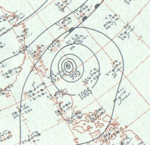
Typhoon Joan[]
| Typhoon (JMA) | |
| Category 5-equivalent super typhoon (SSHWS) | |
  | |
| Duration | August 25 – August 31 |
|---|---|
| Peak intensity | 315 km/h (195 mph) (1-min) 885 hPa (mbar) |
On August 25, Tropical Storm Joan formed in the open Western Pacific, and attained typhoon status early the next day. As Joan moved to the west-northwest, it continued to rapidly intensify, reaching Super Typhoon status on the 28th and peak winds of 195 mph (314 km/h) on the 29th. Such winds are dubious, due to the infancy of Reconnaissance Aircraft at the time and the lack of satellite images. Nevertheless, Joan was a powerful typhoon, and struck eastern Taiwan with estimated winds of 185 mph (298 km/h) on the 29th. It rapidly weakened while crossing the island and the Formosa Strait, and dissipated over China on the 31st. Strong winds and heavy flooding caused 11 casualties and $3 million in crop damage.[2] Property damage was extensive as well, with 3,308 houses destroyed from the typhoon. In China, 3 people were killed and 57 were injured from Joan.[6]
Tropical Storm Kate[]
| Tropical storm (JMA) | |
| Tropical storm (SSHWS) | |
 | |
| Duration | August 25 – August 27 |
|---|---|
| Peak intensity | 75 km/h (45 mph) (1-min) 1000 hPa (mbar) |
Tropical Storm Kate existed just east of the Philippines from August 25 to August 27.
Typhoon Louise[]
| Typhoon (JMA) | |
| Category 4-equivalent typhoon (SSHWS) | |
 | |
| Duration | August 30 – September 7 |
|---|---|
| Peak intensity | 220 km/h (140 mph) (1-min) 965 hPa (mbar) |
Just 5 days after Joan hit Taiwan, 135 mph (217 km/h) Typhoon Louise hit southeastern Taiwan, and quickly weakened as it moved northward. After weakening to a tropical depression over China, it restrengthened to a tropical storm before hitting North Korea and dissipating on September 7. Louise left 6 dead and over 6000 homeless.
Tropical Depression Marge[]
| Tropical depression (JMA) | |
| Tropical depression (SSHWS) | |
 | |
| Duration | September 2 – September 3 |
|---|---|
| Peak intensity | 45 km/h (30 mph) (1-min) 1000 hPa (mbar) |
Tropical Depression Marge existed in the South China Sea from September 2 to September 3.
Tropical Storm Nora[]
| Tropical storm (JMA) | |
| Tropical storm (SSHWS) | |
 | |
| Duration | September 5 – September 12 |
|---|---|
| Peak intensity | 95 km/h (60 mph) (1-min) 990 hPa (mbar) |
Tropical Storm Nora existed from September 5 to September 12.
Tropical Depression Opal[]
| Tropical depression (JMA) | |
| Tropical storm (SSHWS) | |
 | |
| Duration | September 5 – September 6 |
|---|---|
| Peak intensity | 65 km/h (40 mph) (1-min) |
Tropical Storm Opal existed from September 5 to September 6.
Typhoon Patsy[]
| Typhoon (JMA) | |
| Category 4-equivalent typhoon (SSHWS) | |
  | |
| Duration | September 6 – September 10 |
|---|---|
| Peak intensity | 220 km/h (140 mph) (1-min) 965 hPa (mbar) |
On September 6, reports from aircraft indicated the existence of a tropical storm near the International Date Line. Earlier stages were missed because of a lack of data in the isolated area. A trough moved Patsy northeast. A second trough then developed, dominated over the first, and recurved Patsy northeast. It then slowly headed northwards and gradually weakened. It dissipated on September 10. Patsy's erratic path near the dateline was unusual and no known tropical cyclone had taken such a path over the previous ten years,[7] although that of Typhoon June 1958 was somewhat similar.[8]
The Japan Meteorological Agency's "best track" does not give windspeeds, only indicating that Patsy was a typhoon.[9] The Joint Typhoon Warning Center's report disagrees on location but also has Patsy's maximum windspeed east of the dateline;[7] the JMA's data does not indicate windspeeds.[9] Patsy is an uncommon west-to-east crosser of the dateline. Including only systems recognized by the Central Pacific Hurricane Center, that has only happened six times since.[10]
Tropical Depression Ruth[]
| Tropical depression (JMA) | |
| Tropical depression (SSHWS) | |
 | |
| Duration | September 8 – September 10 |
|---|---|
| Peak intensity | 55 km/h (35 mph) (1-min) |
Tropical Depression Ruth existed from September 8 to September 10.
Typhoon Sarah[]
| Typhoon (JMA) | |
| Category 5-equivalent super typhoon (SSHWS) | |
  | |
| Duration | September 11 – September 19 |
|---|---|
| Peak intensity | 305 km/h (190 mph) (1-min) 905 hPa (mbar) |
Super Typhoon Sarah, which peaked at 190 mph (310 km/h) on September 15, weakened to a 115 mph (185 km/h) typhoon just before making landfall on southern South Korea on the 17th. It continued to the northeast, and dissipated on the 19th over northern Japan. In the Ryūkyū Islands, Sarah's high winds and rain caused 6 deaths and destroyed 6,000 houses, causing $2 million in crop damage. In all of Korea, extreme flooding and storm surge killed 669 people and left 782,126 homeless one day before Chuseok, which is one of the Korea's biggest holidays. Extreme crop damage and property damage amounted to $100 million (1959 USD) ($638 million 2005 USD). Flooding in Japan killed 24, with thousands of houses either destroyed or damaged.
Tropical Depression Thelma[]
| Tropical depression (JMA) | |
| Tropical depression (SSHWS) | |
 | |
| Duration | September 18 – September 19 |
|---|---|
| Peak intensity | 55 km/h (35 mph) (1-min) |
Tropical Depression Thelma existed between Palau and Guam from September 18 to September 19.
Typhoon Vera[]
| Typhoon (JMA) | |
| Category 5-equivalent super typhoon (SSHWS) | |
  | |
| Duration | September 21 – September 28 |
|---|---|
| Peak intensity | 305 km/h (190 mph) (1-min) 895 hPa (mbar) |
Vera developed on September 20 between Guam and Chuuk State, and initially tracked westward before taking a more northerly course, reaching tropical storm strength the following day. By this point Vera had assumed a more westerly direction of movement and had begun to rapidly intensify, and reached its peak intensity on September 23 with maximum sustained winds equivalent to that of a modern-day Category 5 hurricane. With little change in strength, Vera curved and accelerated northward, resulting in a landfall on September 26 near Shionomisaki on Honshu. Atmospheric wind patterns caused the typhoon to briefly emerge into the Sea of Japan before recurving eastward and moving ashore Honshu for a second time. Movement over land greatly weakened Vera, and after reentering the North Pacific Ocean later that day, Vera transitioned into an extratropical cyclone on September 27; these remnants continued to persist for an additional two days.
Though Vera was accurately forecast and its track into Japan was well anticipated, limited coverage of telecommunications, combined with lack of urgency from Japanese media and the storm's intensity, greatly inhibited potential evacuation and disaster mitigation processes. Rainfall from the storm's outer rainbands began to cause flooding in river basins well in advance of the storm's landfall. Upon moving ashore Honshu, the typhoon brought a strong storm surge that destroyed numerous flood defense systems, inundating coastal regions and sinking ships. Damage totals from Vera reached US$600 million (equivalent to US$5.33 billion in 2020). The number of fatalities caused by Vera remain discrepant, though current estimates indicate that the typhoon caused more than 5,000 deaths, making it one of the deadliest typhoons in Japanese history. It also injured almost 39,000 people and made around 1.5 million people homeless.[11]
Typhoon Amy[]
| Typhoon (JMA) | |
| Category 1-equivalent typhoon (SSHWS) | |
 | |
| Duration | October 3 – October 9 |
|---|---|
| Peak intensity | 120 km/h (75 mph) (1-min) 985 hPa (mbar) |
Typhoon Amy developed near Yap on October 3. After strengthening and subsequent weakening, Amy struck Japan. Shortly thereafter, the system became extratropical on October 9.
Tropical Storm Babs[]
| Tropical storm (JMA) | |
| Tropical storm (SSHWS) | |
 | |
| Duration | October 5 – October 10 |
|---|---|
| Peak intensity | 75 km/h (45 mph) (1-min) 1005 hPa (mbar) |
Tropical Storm Babs developed in the South China Sea on October 5. The storm struck the western side of Luzon, before entering the Pacific Ocean. By October 10, Babs dissipated south of the Ryukyu Islands.
Typhoon Charlotte[]
| Typhoon (JMA) | |
| Category 5-equivalent super typhoon (SSHWS) | |
  | |
| Duration | October 9 – October 19 |
|---|---|
| Peak intensity | 270 km/h (165 mph) (1-min) 905 hPa (mbar) |
An area of low pressure organized into a tropical depression on October 9 to the east of the Philippines. It moved northwestward, quickly intensifying to typhoon status on the 10th. Charlotte continued to intensify, and reached a peak of 165 mph (266 km/h) on the 13th before recurving to the northeast. Cooler, drier air weakened the typhoon, and after passing near Okinawa on the 16th it paralleled the southern coast of Japan offshore. The weakening storm turned to the east, and dissipated on the 19th. Charlotte brought a total of 24 inches (610 mm) of rain on Okinawa, causing landslides that damaged much of the island. Crop damage was severe, with 75% of the rice crop destroyed. The five feet of flooding in some areas damaged 618 homes and destroyed 275. In all, Charlotte caused 46 casualties and left 1,068 homeless.
Typhoon Dinah[]
| Typhoon (JMA) | |
| Category 5-equivalent super typhoon (SSHWS) | |
 | |
| Duration | October 14 – October 25 |
|---|---|
| Peak intensity | 280 km/h (175 mph) (1-min) 915 hPa (mbar) |
Just weeks after Super Typhoon Vera, another northward moving 170 mph (270 km/h) Super Typhoon was moving northward toward Japan. Dinah's turn to the northeast spared the country, and it became extratropical on October 21 to the east of the archipelago.
Typhoon Emma[]
| Typhoon (JMA) | |
| Category 3-equivalent typhoon (SSHWS) | |
  | |
| Duration | November 5 – November 15 |
|---|---|
| Peak intensity | 205 km/h (125 mph) (1-min) 960 hPa (mbar) |
Typhoon Emma existed from November 5 to November 15.
Typhoon Freda[]
| Typhoon (JMA) | |
| Category 4-equivalent typhoon (SSHWS) | |
 | |
| Duration | November 13 – November 19 |
|---|---|
| Peak intensity | 215 km/h (130 mph) (1-min) 945 hPa (mbar) |
A disturbance in the Intertropical Convergence Zone organized into a tropical storm to the east of the Philippines on November 13. Freda moved west-northwestward, attaining typhoon status the next day. As it paralleled the northeast coast of Luzon, it rapidly intensified to a 135 mph (217 km/h) typhoon, and made landfall on the 16th with slightly weaker winds of 120, the weakening due to land interaction. Freda rapidly weakened as it crossed the island, and turned to the north. After passing close to Taiwan on the 18th, it accelerated to the north and became extratropical on the 20th. Freda brought torrential rains to the city of Manila, driving two vessels aground. Crop damage was heavy on the southern part of the island, while 7,600 were left homeless from the flooding. Freda caused 58 fatalities as it passed through the Philippines.
Typhoon Gilda[]
| Typhoon (JMA) | |
| Category 5-equivalent super typhoon (SSHWS) | |
  | |
| Duration | December 11 – December 22 |
|---|---|
| Peak intensity | 280 km/h (175 mph) (1-min) 925 hPa (mbar) |
On December 18, 175 mph (270 km/h) Super Typhoon Gilda made landfall on the eastern Philippines. It quickly crossed the archipelago, and weakened over the South China Sea. Gilda made landfall on southeastern Vietnam on the 21st as a tropical storm, and dissipated the next day. Gilda caused 23 casualties in the Philippines from extensive rainfall, and left nearly 60,000 homeless.
Typhoon Harriet[]
| Typhoon (JMA) | |
| Category 4-equivalent typhoon (SSHWS) | |
  | |
| Duration | December 22, 1959 – January 3, 1960 |
|---|---|
| Peak intensity | 240 km/h (150 mph) (1-min) 930 hPa (mbar) |
On December 30, just weeks after Gilda, 150 mph (233 km/h) Typhoon Harriet hit the eastern Philippines. It weakened as it crossed the islands, and dissipated over the South China Sea on January 2. Harriet brought strong winds and rainfall to Luzon, causing considerable property and crop damage. In all, the typhoon killed 5 and left more than 12,000 homeless.
Storm names[]
|
|
|
|
Three Central Pacific storms developed and were named Dot, Patsy, and Wanda. The policy at the time was to use the Western Pacific nomenclature for the basin.
See also[]
References[]
- ^ "Wind Season, Worst Ever, Called Over". Spokane Daily Chronicle. Tokyo, Japan. Associated Press. October 22, 1959. p. 30. Retrieved January 5, 2011.
- ^ a b c d e f g h i Tilden, C. E. (1959). Hoffman, R. M (ed.). Annual typhoon report: 1959 (PDF) (Technical report). Fleet Weather Central/Joint Typhoon Warning Center. Archived from the original (PDF) on February 2, 2010. Retrieved 4 August 2013.
- ^ a b c d e f g h i Unisys. "1959 Pacific typhoon season". 1959 Hurricane/Tropical Data for Western Pacific. Archived from the original on 2007-06-11. Retrieved 2007-04-04.
- ^ a b c "159 Annual Tropical Cyclone Report: Typhoon Iris" (PDF). Joint Typhoon Warning Center. United States Navy. 1960. pp. 46–49. Archived from the original (PDF) on June 6, 2011. Retrieved January 2, 2012.
- ^ "The Worst Natural Disasters by Death Toll" (PDF). National Oceanic and Atmospheric Administration. April 6, 2008. Retrieved January 5, 2011.
- ^ Kaff, Albert E. (August 31, 1959). "Typhoon Joan Hits Chinese Mainland". Tyler Morning Telegraph. Vol. 31, no. 289. Tyler, Texas. United Press International. p. 1. Retrieved April 28, 2020 – via Newspapers.com.
- ^ a b "Typhoon Patsy" (PDF). Joint Typhoon Warning Center. Archived from the original (PDF) on 2011-06-07. Retrieved 2008-05-25.
- ^ "The 1959 Central Pacific Tropical Cyclone Season". Central Pacific Hurricane Center. Archived from the original on 27 May 2008. Retrieved 2008-05-31.
- ^ a b "Untitled". Japan Meteorological Agency. Archived from the original on 21 May 2008. Retrieved 2008-05-25.
- ^ "Previous Tropical Systems in the Central Pacific". Central Pacific Hurricane Center. Archived from the original on 9 May 2008. Retrieved 2008-05-25.
- ^ "Ise Bay typhoon of 1959". Encyclopædia Britannica.
External links[]
- Japan Meteorological Agency
- Joint Typhoon Warning Center.
- National Weather Service Guam
- Hong Kong Observatory
- Macau Meteorological Geophysical Services
- Korea Meteorological Agency
- Philippine Atmospheric, Geophysical and Astronomical Services Administration
- Taiwan Central Weather Bureau
- Digital Typhoon - Typhoon Images and Information
- Typhoon2000 Philippine typhoon website
- 1959 Pacific Typhoon Season Animation
Tropical cyclones of the 1959 Pacific typhoon season | ||
|---|---|---|
 | ||
| ||
- 1959 Pacific typhoon season