Honshu
Native name: 本州 | |
|---|---|
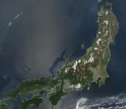 Satellite image of Honshu | |
| Geography | |
| Location | East Asia |
| Archipelago | Japanese archipelago |
| Area | 227,960[1] km2 (88,020 sq mi) |
| Area rank | 7th |
| Length | 1,300 km (810 mi) |
| Width | 50–230 km (31–143 mi) |
| Coastline | 10,084 km (6265.9 mi) |
| Highest elevation | 3,776 m (12388 ft) |
| Highest point | Mount Fuji |
| Administration | |
Japan | |
| Prefectures | |
| Largest settlement | |
| Demographics | |
| Population | 104,000,000[2] (2017 estimate) |
| Pop. density | 447/km2 (1158/sq mi) |
| Ethnic groups | Japanese |
| Additional information | |
| Time zone | |
Honshu (本州, Honshū, pronounced [hoꜜɰ̃ɕɯː] (![]() listen); lit. "main province"), historically called Hondo (本土, mainland), is the largest and most populous main island of Japan.[3][4] It is located south of Hokkaidō across the Tsugaru Strait, north of Shikoku across the Inland Sea, and northeast of Kyūshū across the Kanmon Straits. The island separates the Sea of Japan, which lies to its north and west, from the North Pacific Ocean to the south and east. It is the 7th largest island in the world, and the 2nd most populous after the Indonesian island of Java.[5][6][7]
listen); lit. "main province"), historically called Hondo (本土, mainland), is the largest and most populous main island of Japan.[3][4] It is located south of Hokkaidō across the Tsugaru Strait, north of Shikoku across the Inland Sea, and northeast of Kyūshū across the Kanmon Straits. The island separates the Sea of Japan, which lies to its north and west, from the North Pacific Ocean to the south and east. It is the 7th largest island in the world, and the 2nd most populous after the Indonesian island of Java.[5][6][7]
Honshu had a population of 104 million as of 2017,[2] mostly concentrated in the coastal areas and plains. Approximately 30% of the total population resides in the Greater Tokyo Area on the Kantō Plain. As the historical center of Japanese cultural and political power,[8] the island includes several past Japanese capitals, including Kyōto, Nara and Kamakura. Much of the island's southern shore forms part of the Taiheiyō Belt, a megalopolis that spans several of the Japanese islands.[8] Honshu contains Japan’s highest mountain, Mount Fuji, and its largest lake, Lake Biwa.[9]
Most of Japan's industry is located in a belt running along Honshu's southern coast, from Tokyo to Nagoya, Kyōto, Osaka, Kobe, and Hiroshima;[8] by contrast, the economy along the northwestern Sea of Japan coast is largely based on fishing and agriculture.[10] The island is linked to the other three major Japanese islands by a number of bridges and tunnels. Its climate is humid and mild.
Geography[]

The island is roughly 1,300 km (810 mi) long and ranges from 50 to 230 km (31 to 143 mi) wide, and its total area is 227,960 km2 (88,020 sq mi),[1] making it slightly larger than the island of Great Britain 209,331 km2 (80,823 sq mi).[7] Its land area has been increasing with land reclamation and coastal uplift in the north due to plate tectonics with a convergent boundary. Honshu has 10,084 kilometres (6,266 mi) of coastline.[4]
Mountainous and volcanic, Honshu experiences frequent earthquakes (the Great Kantō earthquake heavily damaged Tokyo in September 1923, and the earthquake of March 2011 moved the northeastern part of the island by varying amounts of as much as 5.3 m (17 ft)[11][12] while causing devastating tsunamis). The highest peak is the active volcano Mount Fuji at 3,776 m (12,388 ft), which makes Honshu the world's 7th highest island. There are many rivers, including the Shinano River, Japan's longest. The Japanese Alps span the width of Honshu, from the 'Sea of Japan' coast to the Pacific shore. The climate is generally humid subtropical in western Japan and humid continental in the north.
Extreme points[]
Bridges and tunnels[]
Honshu is connected to the islands of Hokkaidō, Kyūshū and Shikoku by tunnels and bridges. Three bridge systems have been built across the islands of the Inland Sea between Honshu and Shikoku (Akashi Kaikyō Bridge and the Ōnaruto Bridge; , Innoshima Bridge, , Tatara Bridge, , Hakata–Ōshima Bridge, and the Kurushima-Kaikyō Bridge; Shimotsui-Seto Bridge, Hitsuishijima Bridge, Iwakurojima Bridge, Yoshima Bridge, Kita Bisan-Seto Bridge, and the Minami Bisan-Seto Bridge), the Seikan Tunnel connects Honshu with Hokkaidō, and the Kanmonkyo Bridge and Kanmon Tunnel connects Honshu with Kyūshū.
Population[]
Its population was 104 million people, according to a 2017 estimate. This represents 81.3 percent of the entire population of Japan.[2]
Administrative regions and prefectures[]
The island is divided into five nominal regions and contains 34 prefectures, including metropolitan Tokyo. Administratively, some smaller islands are included within these prefectures, notably including the Ogasawara Islands, Sado Island, Izu Ōshima, and Awaji Island.
The regions and its prefectures are:
- Tōhoku region consists of six prefectures.
- Kantō region consists of seven prefectures, including the capital of Japan which is the Tokyo Metropolis.
- Chūbu region consists of nine prefectures.
- Kansai region consists of seven prefectures.
- Chūgoku region consists of five prefectures.
Natural features[]
Industry[]
Most of Japan's tea and silk is from Honshu. Fruits, vegetables, grains, rice and cotton are grown in Honshu.[13] Niigata is noted as an important producer of rice. The Kantō and Nōbi plains produce rice and vegetables. Yamanashi is a major fruit-growing area, and Aomori is famous for its apples.[citation needed] Rare species of the lichen genus Menegazzia are found only in Honshu.[14]
Minerals[]
Yields of zinc, copper, and oil have been found on Honshu.[13]
Gallery[]

View of Japan taken from a satellite. Honshu is in the middle. (1999)

See also[]
References[]
| Wikivoyage has a travel guide for Honshu. |
| Wikimedia Commons has media related to Honshu. |
- ^ Jump up to: a b Farjon, Aljos; Filer, Denis (2013). An Atlas of the World's Conifers: An Analysis of their Distribution, Biogeography, Diversity and Conservation Status. BRILL. p. 268. ISBN 9789004211810.
- ^ Jump up to: a b c Boquet, Yves (2017). The Philippine Archipelago. Springer. p. 16. ISBN 9783319519265.
- ^ "離島とは(島の基礎知識) (what is a remote island?)". MLIT (Ministry of Land, Infrastructure, Transport and Tourism) (in Japanese). Ministry of Land, Infrastructure, Transport and Tourism. 22 August 2015. Archived from the original (website) on 2007-07-13. Retrieved 9 August 2019.
MILT classification 6,852 islands(main islands: 5 islands, remote islands: 6,847 islands)
- ^ Jump up to: a b "Honshu". Encyclopædia Britannica. Retrieved 19 February 2016.
- ^ Japan Civil Registry Database 2013
- ^ See Japan Census of 2000; the editors of List of islands by population appear to have used similar data from the relevant statistics bureaux and totalled up the various administrative districts that make up each island, and then done the same for less populous islands. An editor of this article has not repeated that work. Therefore this plausible and eminently reasonable ranking is posted as unsourced common knowledge.
- ^ Jump up to: a b "Islands By Land Area". Islands.unep.ch. Retrieved 2010-08-01.
- ^ Jump up to: a b c Dolan, Ronald; Worden, Robert (1992). Japan: a country study. Federal Research Division, Library of Congress.
- ^ "Honshu | Facts, History, & Points of Interest". Encyclopedia Britannica. Retrieved 2021-04-14.
- ^ Kodansha Encyclopedia of Japan
- ^ "Map of Horizontal Land Movement caused by 2011/3/11 M9.0 earthquake" (PDF) (in Japanese). Geospatial Information Authority of Japan. March 19, 2011. Retrieved 15 November 2012.
- ^ "Quake shifted Japan by over two meters". Deutsche Welle. March 14, 2011. Retrieved March 14, 2011.
- ^ Jump up to: a b "Honshu". infoplease.com. 2012. Retrieved 2014-11-23.
- ^ Bjerke JW (2004). "Revision of the lichen genus Menegazzia in Japan, including two new species". The Lichenologist. 36 (1): 15–25. doi:10.1017/S0024282904013878. ISSN 0024-2829.

| show Authority control |
|---|

- Honshu
- Islands of Japan
- Japanese archipelago