Nara Prefecture
Nara Prefecture
奈良県 | |||||||||||||||
|---|---|---|---|---|---|---|---|---|---|---|---|---|---|---|---|
| Japanese transcription(s) | |||||||||||||||
| • Japanese | 奈良県 | ||||||||||||||
| • Rōmaji | Nara-ken | ||||||||||||||
 Flag  Symbol | |||||||||||||||
 | |||||||||||||||
| Country | |||||||||||||||
| Region | Kansai | ||||||||||||||
| Island | Honshu | ||||||||||||||
| Capital | Nara | ||||||||||||||
| Subdivisions | Districts: 7, Municipalities: 39 | ||||||||||||||
| Government | |||||||||||||||
| • Governor | Shōgo Arai | ||||||||||||||
| Area | |||||||||||||||
| • Total | 3,691.09 km2 (1,425.14 sq mi) | ||||||||||||||
| Area rank | 40th | ||||||||||||||
| Population (December 1st, 2020)http://www.pref.nara.jp/6265.htm | |||||||||||||||
| • Total | 1,321,805 | ||||||||||||||
| • Rank | 30th | ||||||||||||||
| • Density | 358.10/km2 (927.5/sq mi) | ||||||||||||||
| ISO 3166 code | JP-29 | ||||||||||||||
| Website | www | ||||||||||||||
| |||||||||||||||
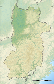
Nara Prefecture (奈良県, Nara-ken) is a prefecture of Japan located in the Kansai region of Honshu.[2] As of 2020, Nara Prefecture has a population of 1,321,805[3] and has a geographic area of 3,691 square kilometres (1,425 sq mi). Nara Prefecture borders Kyoto Prefecture to the north, Osaka Prefecture to the northwest, Wakayama Prefecture to the southwest, and Mie Prefecture to the east.
Nara is the capital and largest city of Nara Prefecture, with other major cities including Kashihara, Ikoma, and Yamatokōriyama.[4] Nara Prefecture is located in the center of the Kii Peninsula on Japan's Pacific Ocean coast, and is one of only eight landlocked prefectures. Nara Prefecture has the distinction of having more UNESCO World Heritage listings than any other prefecture in Japan.[5]
History[]
Nara Prefecture region is considered one of the oldest regions in Japan, having been in existence for thousands of years, and is widely viewed as the Japanese cradle of civilization. Like Kyoto, Nara was one of Imperial Japan's earliest capital cities.[6][7] The current form of Nara Prefecture was officially created in 1887 when it became independent of Osaka Prefecture.
Historically, Nara Prefecture was also known as Yamato-no-kuni or Yamato Province.[8]
Up to Nara Period[]
From the third century to the fourth century, a poorly documented political force existed at the foot of Mount Miwa, east of Nara Basin. It sought unification of most parts in Japan. Since the historical beginning of Japan, Yamato was its political center.
Ancient capitals of Japan were built on the land of Nara, namely Asuka-kyō, Fujiwara-kyō (694–710)[9] and Heijō-kyō (most of 710–784).[10] The capital cities of Fujiwara and Heijō are believed to have been modeled after Chinese capitals at the time, incorporating grid layout patterns. The royal court also established relations with Sui and then Tang dynasty China and sent students to the Middle Kingdom to learn high civilization. By 7th century, Nara accepted the many immigrants including refugees of Baekje who had escaped from war disturbances of the southern part of the Korean Peninsula. The first high civilization with royal patronage of Buddhism flourished in today's Nara city (710–784 AD).
Nara in the Heian period[]

In 784, Emperor Kanmu decided to relocate the capital to Nagaoka-kyō in Yamashiro Province, followed by another move in 794 to Heian-kyō, marking the start of the Heian period. The temples in Nara remained powerful beyond the move of political capital, thus giving Nara a synonym of "Nanto" (meaning "South Capital") as opposed to Heian-kyō, situated in the north. Close to the end of Heian period, Taira no Shigehira, a son of Taira no Kiyomori, was ordered by his father to depress the power of various parties, mainly Kōfuku-ji and Tōdai-ji, who were backing up an opposition group headed by Prince Mochihito. The movement led to a collision between the Taira and the Nara temples in 1180. This clash eventually led to Kōfuku-ji and Tōdai-ji being set on fire, resulting in vast destruction of architectural heritage.
Medieval Nara[]

At the rise of the Minamoto to its ruling seat and the opening of Kamakura shogunate, Nara enjoyed the support of Minamoto no Yoritomo toward restoration. Kōfuku-ji, being the "home temple" to the Fujiwara since its foundation, not only regained the power it had before but became a de facto regional chief of Yamato Province. With the reconstruction of Kōfuku-ji and Tōdai-ji, a town was growing again near the two temples.
The Nanboku-chō period, starting in 1336, brought more instability to Nara. As Emperor Go-Daigo chose Yoshino as his base, a power struggle arose in Kōfuku-ji with a group supporting the South and another siding the North court. Likewise, local clans were split into two. Kōfuku-ji recovered its control over the province for a short time at the surrender of the South Court in 1392, while the internal power game of the temple itself opened a way for the local samurai clans to spring up and fight with each other, gradually acquiring their own territories, thus diminishing the influence of Kōfuku-ji overall.
The Sengoku and Edo periods to present[]

Later, the whole province of Yamato got drawn into the confusion of the Sengoku period. Tōdai-ji was once again set on fire in 1567, when Matsunaga Hisahide, who was later appointed by Oda Nobunaga to the lord of Yamato Province, fought for supremacy against his former master Miyoshi family. Followed by short appointments of Tsutsui Junkei and Toyotomi Hidenaga by Toyotomi Hideyoshi to the lord, the Tokugawa shogunate ultimately ruled the city of Nara directly, and most parts of Yamato province with a few feudal lords allocated at Kōriyama, Takatori and other places. With industry and commerce developing in the 18th century, the economy of the province was incorporated into prosperous Osaka, the commercial capital of Japan at the time.
The economic dependency to Osaka even characterizes today's Nara Prefecture, for many inhabitants commute to Osaka to work or study there.
The establishment of Nara Prefecture[]
A first prefecture (briefly -fu in 1868, but -ken for most of the time)[11] named Nara was established in the Meiji Restoration in 1868 as successor to the shogunate administration of the shogunate city and shogunate lands in Yamato. After the 1871 Abolition of the han system, Nara was merged with other prefectures (from former han, see List of Han#Yamato Province) and cleared of ex-/enclaves to encompass all of Yamato province. In 1876, Nara was merged into which in turn became part of Osaka in 1881. In 1887, Nara became independent again. The first prefectural assembly of Nara was elected in the same year and opened its first session in 1888 in the gallery of the main hall of Tōdai temple.[12]
In the 1889 Great Meiji mergers which subdivided all (then 45) prefectures into modern municipalities, Nara prefecture's 16 districts were subdivided into 154 municipalities: 10 towns and 144 villages. The first city in Nara was only established in 1898 when Nara Town from Soekami District was made district-independent to become Nara City (see List of mergers in Nara Prefecture and List of mergers in Osaka Prefecture).
Geography[]

City Town Village
Nara Prefecture is part of the Kansai, or Kinki, region of Japan, and is located in the middle of the Kii Peninsula on the western half of Honshu. Nara Prefecture is landlocked. It is bordered to the west by Wakayama Prefecture and Osaka Prefecture; on the north by Kyoto Prefecture and on the east by Mie Prefecture.
Nara Prefecture is 78.5 kilometres (48.8 mi) from east to west and 103.6 kilometres (64.4 mi) from north to south.
Most of the prefecture is covered by mountains and forests, leaving an inhabitable area of only 851 square kilometres (329 sq mi). The ratio of inhabitable area to total area is 23%, ranked 43rd among the 47 prefectures in Japan.[13]
Nara Prefecture is bisected by the Japan Median Tectonic Line (MTL) running through its territory east to west, along the Yoshino River. On the northern side of the MTL is the so-called Inner Zone, where active faults running north to south are still shaping the landscape. The Ikoma Mountains in the northwest form the border with Osaka Prefecture. The Nara Basin, which lies to the east of these mountains, contains the highest concentration of population in Nara Prefecture. Further east are the Kasagi Mountains, which separate the Basin from the Yamato Highlands.
South of the MTL is the Outer Zone, comprising the Kii Mountains, which occupy about 60% of the land area of the prefecture. The Ōmine Range is in the center of the Kii Mountains, running north to south, with steep valleys on both sides. The tallest mountain in Nara Prefecture, and indeed in the Kansai region, is Mount Hakkyō. To the west, separating Nara Prefecture from Wakayama Prefecture, is the Obako Range, with peaks around 1,300 metres (4,300 ft). To the east, bordering Mie Prefecture, is the Daikō Range, including Mount Ōdaigahara. This mountainous region is also home to a World Heritage Site, the Sacred Sites and Pilgrimage Routes in the Kii Mountain Range".
About 17% of the total land area of the prefecture is designated as National Park land, comprising the Yoshino-Kumano National Park, Kongō-Ikoma-Kisen, Kōya-Ryūjin, Murō-Akame-Aoyama, and Yamato-Aogaki Quasi-National Parks; and the Tsukigase-Kōnoyama, Yata, and Yoshinogawa-Tsuboro Prefectural Natural Parks.[14]
Climate[]

In the Nara Basin, the climate has inland characteristics, as represented in the bigger temperature variance within the same day, and the difference of summer and winter temperatures. Winter temperatures average about 3 to 5 °C (37 to 41 °F), and 25 to 28 °C (77 to 82 °F) in the summer with highest reaching close to 35 °C (95 °F). There is not a single year over the last decade (since 1990, up to 2007) with more than 10 days of snowfall recorded by Nara Local Meteorological Observatory.
The climate in the rest of the prefecture are mountainous, and especially in the south, with below −5 °C (23 °F) being the extreme minimum in winter. Heavy rainfall is observed in summer. The annual accumulated rainfall ranges as much as 3,000 to 5,000 millimetres (120 to 200 in), which is among the heaviest in Japan.
Spring and fall are temperate. The mountainous region of Yoshino has been popular both historically and presently for its cherry blossoms in the spring. In the fall, the southern mountains are equally striking with the changing of the oak trees.[citation needed]

Cities[]
There are twelve cities in Nara Prefecture:
| Name | Area (km2) | Population | Map | |
|---|---|---|---|---|
| Rōmaji | Kanji | |||
| 五條市 | 291.98 | 33,283 | 
| |
| 御所市 | 60.65 | 26,522 | 
| |
| 生駒市 | 53.18 | 120,741 | 
| |
| 香芝市 | 24.23 | 79,023 | 
| |
| 橿原市 | 39.52 | 124,829 | 
| |
| 葛
| ||||