Kashihara, Nara
This article needs additional citations for verification. (September 2015) |
Kashihara
橿原市 | |
|---|---|
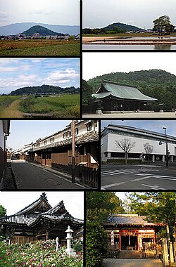 Left:Mount Unebi, Mount Amanokaga, Imai heritage old house site, Ofusa Kannon Temple, Right:Mount Miminashi, Kashihara Shrine, , Unebi-yamaguchi Shrine (all item from above to bottom) | |
 Flag  Emblem | |
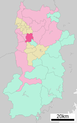 Location of Kashihara in Nara Prefecture | |
 Kashihara Location in Japan | |
| Coordinates: 34°31′N 135°48′E / 34.517°N 135.800°ECoordinates: 34°31′N 135°48′E / 34.517°N 135.800°E | |
| Country | Japan |
| Region | Kansai |
| Prefecture | Nara Prefecture |
| Government | |
| • Mayor | Yutaka Morishita |
| Area | |
| • Total | 39.52 km2 (15.26 sq mi) |
| Population (April 1, 2015) | |
| • Total | 124,829 |
| • Density | 3,176.79/km2 (8,227.8/sq mi) |
| Time zone | UTC+09:00 (JST) |
| City hall address | 1-1-18 Yagi-chō, Kashihara-shi, Nara-ken 634-8586 |
| Website | www |
| Symbols | |
| Flower | Common gardenia |
| Tree | Oak |

Kashihara (橿原市, Kashihara-shi) is a city located in Nara Prefecture, Japan. As of April 1, 2015, the city has an estimated population of 124,829, with 52,034 households.[1] Population density is around 3,176.79 persons per km², and the total area is 39.52 km².[citation needed]
The city was founded on February 11, 1956. The former mayor was Yutaka Asoda, who was elected to his third term of office in 2003. The present mayor is Yutaka Morishita, who was elected in 2007.
The exact spot of Emperor Jimmu's accession to the imperial throne (i.e. the foundation of Japan) was debated for centuries until in 1863 an area that is now part of the city was claimed to be the exact location. The city was the location of the Imperial capital Fujiwara-kyō, from 694 to 710.
In the late 16th century it was said to be one of the two richest autonomous cities of Japan, as in Umi no Sakai, Riku no Imai (tr. "by the sea, Sakai – inland, Imai" - Imai or ja:今井町 is now a part of Kashihara).
 Mount Unebi, one of Yamato Sanzan |
 Imai area, built in around the 15th century |
Transport[]
Rail[]
- Kintetsu Railway
- Osaka Line: (<< for Osaka) - Masuga - Yamato-Yagi - Miminashi - (for Toba, Nagoya >>)
- Kashihara Line: (<< for Kyoto) - Ninokuchi - Yamato-Yagi - Yagi-nishiguchi - Unebigoryomae - Kashiharajingu-mae (line terminus)
- Minami Osaka Line: Bojo - Kashiharajingu-nishiguchi - Kashiharajingu-mae - (Yoshino Line >>)
- Yoshino Line: (<< Minami-Osaka Line) - Kashiharajingu-mae - Okadera - (Yoshino >>)
- West Japan Railway Company
- Sakurai Line: (<< for Yamatotakada) - Unebi - (for Nara >>)
Road[]
- Expressways
 Japan National Route 24
 Japan National Route 165
 Japan National Route 166
 Japan National Route 169
See also[]
References[]
- ^ "市町村別推計人口・世帯数". Nara Prefecture. April 1, 2015. Archived from the original on May 18, 2015. Retrieved May 5, 2015.
External links[]
| Wikimedia Commons has media related to Kashihara, Nara. |
- Kashihara City official website (in Japanese)
- Kashihara City official tourism website (English)
 Geographic data related to Kashihara, Nara at OpenStreetMap
 Kashihara travel guide from Wikivoyage
| show Authority control |
|---|
- Kashihara, Nara
- Cities in Nara Prefecture