Ikoma, Nara
Ikoma
生駒市 | |||||||||||
|---|---|---|---|---|---|---|---|---|---|---|---|
 Ikoma City | |||||||||||
 Flag  Emblem | |||||||||||
 Location of Ikoma in Nara Prefecture | |||||||||||
 Ikoma Location in Japan | |||||||||||
| Coordinates: 34°42′N 135°42′E / 34.700°N 135.700°ECoordinates: 34°42′N 135°42′E / 34.700°N 135.700°E | |||||||||||
| Country | Japan | ||||||||||
| Region | Kansai | ||||||||||
| Prefecture | Nara Prefecture | ||||||||||
| Government | |||||||||||
| • Mayor | Makoto Yamashita | ||||||||||
| Area | |||||||||||
| • Total | 53.18 km2 (20.53 sq mi) | ||||||||||
| Population (April 1, 2017) | |||||||||||
| • Total | 120,741 | ||||||||||
| • Density | 2,300/km2 (5,900/sq mi) | ||||||||||
| Time zone | UTC+09:00 (JST) | ||||||||||
| City hall address | 8-38 Higashi-shinmachi, Ikoma-shi, Nara-ken 630-0288 | ||||||||||
| Website | www | ||||||||||
| |||||||||||

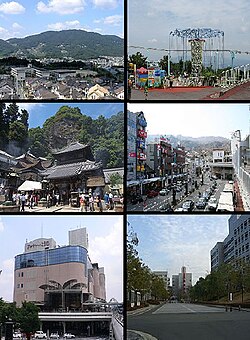
Ikoma (生駒市, Ikoma-shi) is a city in the northwestern end of Nara Prefecture, Japan. It was founded on November 1, 1971. As of April 1, 2017, the city had an estimated population of 120,741, with 49,672 households.[1] It had a population density of 2,300 persons per km², and it is the third biggest population in the prefecture. The total area is 53.18 km². The city is famous for chasen.[2] Kansai Science City is partially located in Ikoma, which is also home to the Nara Institute of Science and Technology.
Notable locations[]
- Mount Ikoma
- Skyland Ikoma (amusement park on top Mount Ikoma)
- Kurondo-ike Pond
- Kuragari-toge Pass
Religious institutions[]
- Ikoma Jinja
- Hozan-ji
- Chikurin-ji
- Chokyu-ji
- Chofuku-ji
- Enpuku-ji
- Sekibutsu-Ji
Transportation[]
Rail[]
- Kintetsu Railway
- Nara Line: Ikoma Station - Higashi-Ikoma Station
- Ikoma Line: Ikoma Station - Nabata Station - Ichibu Station - Minami-Ikoma Station - Haginodai Station - Higashiyama Station
- Keihanna Line: Ikoma Station - Shiraniwadai Station - Gakken Kita-Ikoma Station - Gakken Nara-Tomigaoka Station
- Ikoma Cable Line: Toriimae Station (Ikoma Station) - Hōzanji Station - Umeyashiki Station - Kasumigaoka Station - Ikoma-Sanjō Station
Roads[]
- Expressways
- Hanshin Expressway Dainihanna Route
 Japan National Route 163
 Japan National Route 168
 Japan National Route 308
- Shigi Ikoma Skyline [1]
Gallery[]

Kintetsu Ikoma Station
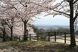
Cherry blossoms at Ikoma Fureai Center

Exiting the train station in Ikoma
Mt. Ikoma eastward

"Take no Kanboshi" is solar desiccation of bamboo for making "chasen" (tea whisks).

Habataki Ikoma building


References[]
- ^ "Official website of Ikoma city" (in Japanese). Japan: Ikoma City. Archived from the original on 5 February 2007. Retrieved 23 April 2017.
- ^ "Takayama Tea Whisks" (PDF). METI KANSAI. Archived from the original (PDF) on February 5, 2013. Retrieved February 18, 2015.
External links[]
![]() Media related to Ikoma, Nara at Wikimedia Commons
Media related to Ikoma, Nara at Wikimedia Commons
- Ikoma City official website (in Japanese)
- NPO of Ikoma support intellectual disabilities and their families official website (in English)
| show Authority control |
|---|
- Cities in Nara Prefecture