Yoshino-Kumano National Park
| Yoshino-Kumano National Park | |
|---|---|
| 吉野熊野国立公園 | |
 Hashigui-iwa | |
| Location | Kansai, Japan |
| Area | 597.93 km² |
| Established | 1 February 1936 |
Yoshino-Kumano National Park (吉野熊野国立公園, Yoshino-Kumano Kokuritsu Kōen) is a national park comprising several non-contiguous areas of Mie, Nara, and Wakayama Prefectures, Japan. Established in 1936, the park includes Mount Yoshino, celebrated for its cherry blossoms, as well as elements of the UNESCO World Heritage Site Sacred Sites and Pilgrimage Routes in the Kii Mountain Range.[1][2]
Places of interest[]
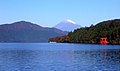
Notable places of interest include the Dorokyō Gorge, Kumano Hongū Taisha, Kushimoto Marine Park, Mount Ōdaigahara, Mount Ōmine, Mount Yoshino, and Nachi Falls.[1][3][4][5]
Related municipalities[]
The park crosses the borders of five cities, seven towns, and six villages:[6]
- Mie: Kihō, Kumano, Mihama, Ōdai, Owase
- Nara: Gojō, Kamikitayama, Kawakami, Shimokitayama, Tenkawa, Totsukawa, Yoshino
- Wakayama: Kitayama, Kushimoto, Nachikatsuura, Shingū, Taiji, Tanabe
See also[]
| Wikimedia Commons has media related to Yoshino-Kumano National Park. |
References[]
- ^ Jump up to: a b "Introducing places of interest: Yoshino-Kumano National Park". Ministry of the Environment. Archived from the original on February 8, 2012. Retrieved 2 February 2012.
- ^ Sutherland, Mary; Britton, Dorothy (1995). National Parks of Japan. Kodansha. pp. 103–6.
- ^ "Yoshino-Kumano National Park". Mie Prefecture. Retrieved 3 February 2012.
- ^ "Yoshino-Kumano National Park". Nara Prefecture. Retrieved 3 February 2012.
- ^ "Yoshino-Kumano National Park". Wakayama Prefecture. Retrieved 3 February 2012.
- ^ "Yoshino-Kumano National Park - Basic Information". Ministry of the Environment. Archived from the original on January 29, 2013. Retrieved 2 February 2012.
External links[]
- (in English) Yoshino-Kumano National Park
- (in Japanese) Yoshino-Kumano National Park
- Map of Yoshino-Kumano National Park (north)
- Map of Yoshino-Kumano National Park (south)
Coordinates: 33°47′56″N 135°56′24″E / 33.79889°N 135.94000°E

Categories:
- IUCN Category II
- National parks of Japan
- Parks and gardens in Mie Prefecture
- Parks and gardens in Wakayama Prefecture
- Parks and gardens in Nara Prefecture
- Protected areas established in 1936