Setonaikai National Park
| Setonaikai National Park | |
|---|---|
| 瀬戸内海国立公園 | |
 | |
| Location | Seto Inland Sea, Japan |
| Area | 669.34 km² |
| Established | March 16, 1934[1] |
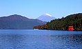
Setonaikai National Park (瀬戸内海国立公園, Setonaikai Kokuritsu Kōen) is a national park comprising areas of Japan's Inland Sea and of ten bordering prefectures. Designated a national park in 1934, it has since been expanded several times. It contains about 3,000 islands, known as the Setouchi Islands,[2] including the well-known Itsukushima. As the park is formed of many non-contiguous areas and covers a tiny proportion of the Inland Sea's total extent, control and protection is problematic, with much of the wider area heavily industrialized.[3][4]
History[]
In 1934, when the park was designated as the first national park in Japan, the area was much smaller than the area is now. Sixteen years later, it was extended to almost the same size as now to include other famous places in the area. It is the biggest national park in Japan.
In 1996, Itsukushima Shrine in Hiroshima prefecture was registered as a cultural site of world heritage by UNESCO.[5] It is known as one of the three most scenic spots in Japan.
In the 1960s and 1970s, which was a period of rapid economic growth in Japan, industrialization contaminated the environment. For example, bank protection works, pollution of the discharge from chemical works, and farm cultivation led to environmental deterioration. These changes had an influence on an ecosystem and water pollution. Recently, the water has been improved because of a high-performance sewage disposal.[6][7]
Climate[]
It is warm weather around the park throughout the year, so the climate is called a Mediterranean climate. Since the area is easily accessible by public transport, people have lived on the coast to work on the land, taking advantage of the warmth. Mandarin oranges and sweet potato are examples of special products in the area. Compared to the Mediterranean Sea, the Inland Sea has more minerals in the water, so there are plentiful plankton. The diversity of creatures is one of the fascinations in the park.
Sites[]
There are numerous sightseeing places in the national park. Kanmon Strait is one of them. It is between Honshu and Kyushu. A suspension bridge called Kanmon Bridge spans the strait. In 1973, when it was opened for the public, it was the longest bridge (0.66 miles) in Asia.[8]
The Naruto whirlpools in Tokushima prefecture are tidal whirlpools in the Naruto Strait, a channel between Naruto and Awaji Island in Hyogo prefecture. The whirlpools, one of the prefecture’s major tourist attractions, are formed due to a narrow width (0.8 miles) of the strait and a water level of 5.6 feet between the Inland Sea and the Open Sea caused by the ebb and flow of the tide. It sometimes creates a whirlpool 100 feet in diameter.[9]
Facilities[]
There are facilities where people can experience and learn about nature in the park. Mt. Rokko Nature Conservation Center and Mt. Rokko Guide House in Hyogo prefecture are places where people can find natural specimens of Mt. Rokko.[10]
Wasuzan Business Center is in Okayama prefecture. It stands on the top of Washuzan Mountain. It is near Seto-ohashi Bridge which is a series of ten bridges between Okayama and Kagawa prefectures. The total length is 8.1 miles (13.1 km). From the center, people can see the panorama of the bridge and the Inland Sea. It is possible to learn about the nature around the bridge and the history of the Inland Sea.[11]
Natural areas[]
- Islands: Awaji Island (part), Bōyo Islands, Ieshima, Miyajima, Naoshima, Shiwaku Islands, Shōdoshima, Tomogashima
- Mountains: Mount Rokkō, Mount Maya, Mount Noro
- Straits: Akashi Strait, Hōyo Strait, Kitan Strait, Naruto Strait, Kanmon Straits
- Other: Naruto whirlpools[12]
Cultural sites[]
- Shrines: Itsukushima Jinja, Kotohira-gū, Mekari Shrine
- Temples: Futago-ji, Yashima-ji[12]
Related municipalities[]
The park crosses the borders of 55 cities, 14 towns, and one village:[1]
- Ehime: Ikata, Imabari, Kamijima, Matsuyama, Ōzu, Saijō, Yawatahama
- Fukuoka: Kitakyushu
- Hiroshima: Etajima, Fukuyama, Hatsukaichi, Higashihiroshima, Hiroshima, Kure, Mihare, Onomichi, Ōsakikamijima, Ōtake, Saka, Takehara
- Hyōgo: Aioi, Akashi, Akō, Ashiya, Awaji, Himeji, Kobe, Minamiawaji, Nishinomiya, Sumoto, Takarazuka, Tatsuno
- Kagawa: Higashikagawa, Kan'onji, Kotohira, Mannō, Marugame, Mitoyo, Naoshima, Sakaide, Sanuki, Shōdoshima, Tadotsu, Takamatsu, Tonoshō, Zentsūji
- Ōita: Bungotakada, Himeshima, Kunisaki, Ōita
- Okayama: Asakuchi, Bizen, Kasaoka, Kurashiki, Okayama, Setouchi, Tamano
- Tokushima: Naruto
- Wakayama: Wakayama
- Yamaguchi: Hikari, Hirao, Hōfu, Iwakuni, Kaminoseki, Kudamatsu, Shimonoseki, Shūnan, Suō-Ōshima, Tabuse, Yanai
See also[]
| Wikimedia Commons has media related to Setonaikai National Park. |
References[]
- ^ Jump up to: a b "Setonaikai National Park - Basic Information". Ministry of the Environment. Archived from the original on 17 May 2012. Retrieved 1 February 2012.
- ^ "Setouchi Islands". Japan National Tourism Organization. Retrieved 28 June 2019.
- ^ "Setonaikai National Park". Ministry of the Environment. Archived from the original on 16 March 2010. Retrieved 1 February 2012.
- ^ Sutherland, Mary; Britton, Dorothy (1995). National Parks of Japan. Kodansha. pp. 125–7.
- ^ Azimi, Nassrine. The New York Times. “When Nature Is Not Enough.” May 8, 2013.
- ^ Baeck, Gun Wook; Park, Joo Myun; Hiroaki “Feeding ecology of three tonguefishes, Genus Cynoglossus (Cynoglossidae) in the Seto Inland Sea, Japan. Dec. 2011.
- ^ Irizuki, Toshiaki, “Anthropogenic impacts on meiobenthic Ostracoda (Crustacea) in the moderately polluted Kasado Bay, Seto Inland Sea, Japan, over the past 70 years.
- ^ “Shimonoseki: Kanmon Straits” Japan Travel, 2016
- ^ ”Japan Monthly Web Magazine” Japan National Tourism Organization, 2016
- ^ “Mt. Rokko Guide House,” Hyogo Prefectural Mt. Rokko Nature Conservation Center and Mt. Rokko Guide House
- ^ ”Facilities - Setonaikai National Park” Ministry of the Environment, 1 February 2012.
- ^ Jump up to: a b "Introducing places of interest: Setonaikai National Park". Ministry of the Environment. Archived from the original on 26 January 2012. Retrieved 1 February 2012.
External links[]
- (in English) Setonaikai National Park
- (in Japanese) Setonaikai National Park
- Map of Setonaikai National Park - Area 1
- Map of Setonaikai National Park - Area 2
- Map of Setonaikai National Park - Area 3
- Map of Setonaikai National Park - Area 4

- IUCN Category II
- National parks of Japan
- Parks and gardens in Ehime Prefecture
- Parks and gardens in Ōita Prefecture
- Parks and gardens in Hiroshima Prefecture
- Parks and gardens in Kagawa Prefecture
- Parks and gardens in Hyōgo Prefecture
- Parks and gardens in Wakayama Prefecture
- Parks and gardens in Okayama Prefecture
- Parks and gardens in Yamaguchi Prefecture
- Parks and gardens in Tokushima Prefecture
- Parks and gardens in Fukuoka Prefecture
- Protected areas established in 1934
- 1934 establishments in Japan