Kan'onji, Kagawa
Kan-onji
観音寺市 | |
|---|---|
| Kan-onji City | |
 Sand Coin Effigy (Zenigata suna-e) in Kotohiki Park | |
 Flag  Emblem | |
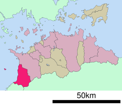 Location of Kan-onji in Kagawa Prefecture | |
 Kan-onji Location in Japan | |
| Coordinates: 34°7′38″N 133°39′41″E / 34.12722°N 133.66139°ECoordinates: 34°7′38″N 133°39′41″E / 34.12722°N 133.66139°E | |
| Country | Japan |
| Region | Shikoku |
| Prefecture | Kagawa Prefecture |
| Government | |
| • Mayor | Seiji Shirakawa (since November 2005, and before merger with former Kan-onji mayor since July 1995) |
| Area | |
| • Total | 117.47 km2 (45.36 sq mi) |
| Population (May 1, 2011) | |
| • Total | 63,721 |
| • Density | 542.44/km2 (1,404.9/sq mi) |
| Time zone | UTC+09:00 (JST) |
| City hall address | Sakamoto-cho 1-1-1, Kan-onji City, Kagawa Prefecture (香川県観音寺市坂本町1丁目1番1号) 768-8601 |

Kan-onji (観音寺市, Kan'onji-shi) is a city located in Kagawa Prefecture, Japan. As of May 1, 2011, the city has an estimated population of 63,721, with 23,480 households and a population density of 542.44 persons per km². The total area is 117.45 km².
The modern city of Kan-onji was established on October 11, 2005, from the merger of the towns of Ōnohara and Toyohama (both from Mitoyo District).
Kotohiki Park of tourist attraction includes the coin shaped sand drawing which modelled Kan'ei Tsūhō.
External links[]
| Wikimedia Commons has media related to Kan'onji, Kagawa. |
- Kan-onji City official website (in Japanese)
- A tourist's report of Kan-onji
| show Authority control |
|---|
This Kagawa Prefecture location article is a stub. You can help Wikipedia by . |
Categories:
- Cities in Kagawa Prefecture
- Kagawa geography stubs