Ōnuma Quasi-National Park
| Ōnuma Quasi-National Park | |
|---|---|
| 大沼国定公園 | |
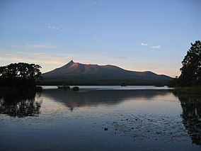 Hokkaidō Komagatake, in the center of the park, at dusk. | |
 | |
| Location | Hokkaidō, Japan |
| Nearest city | Nanae |
| Coordinates | 42°00′44″N 140°40′16″E / 42.0121°N 140.671°E[1]Coordinates: 42°00′44″N 140°40′16″E / 42.0121°N 140.671°E[1] |
| Area | 90.83 km2 (35.07 sq mi) |
| Established | July 1, 1958 |
| Official name | Onuma |
| Designated | 3 July 2012 |
| Reference no. | 2058[2] |

Ōnuma Quasi-National Park (大沼国定公園, Ōnuma Kokutei Kōen) is a 90.83 km2 (35.07 sq mi)[1] quasi-national park on the Oshima Peninsula in southwest Hokkaidō, Japan. The park encompasses the volcanic Hokkaidō Komagatake (北海道駒ケ岳, Hokkaidō Koma-ga-take) as well as the Ōnuma (大沼) and Konuma (小沼) ponds, which abut against the west slope of the mountain. The park, which was designated as quasi-national in 1958, is the smallest major park in Hokkaidō.
Ōnuma and Konuma were created when mudflows due to eruptions of Hokkaidō Koma-ga-take dammed up depressions at the base of the mountain. The ponds, which are dotted with watershields, are surrounded by birch and maple forests.
Related cities, towns and villages[]
See also[]
References[]
- ^ Jump up to: a b Onuma Quasi National Park protectedplanet.net
- ^ "Onuma". Ramsar Sites Information Service. Retrieved 25 April 2018.
External links[]
- J-IBIS (in Japanese)
This Hokkaidō location article is a stub. You can help Wikipedia by . |
This article about a national/quasi-national park or protected area in Japan, or related topic is a stub. You can help Wikipedia by . |
- IUCN Category II
- National parks of Japan
- Parks and gardens in Hokkaido
- Protected areas established in 1958
- Hokkaidō geography stubs
- Japan protected area stubs