Sanin Kaigan National Park
| Sanin Kaigan National Park | |
|---|---|
| 山陰海岸国立公園 | |
 Takeno Beach | |
| Location | San'in, Japan |
| Coordinates | 36°33′45″N 136°21′44″E / 36.5626°N 136.3623°ECoordinates: 36°33′45″N 136°21′44″E / 36.5626°N 136.3623°E |
| Area | 87.83 km² |
| Established | 15 July 1963 |


Sanin Kaigan National Park (山陰海岸国立公園, San'in Kaigan Kokuritsu Kōen) is a National Park in Tottori, Hyōgo, and Kyōto Prefectures, Japan.[1] Established in 1963, the park runs continuously along the Sea of Japan coast from Tottori to Kyōtango.[1][2][3] The park covers 87.83 km². Sanin Kaigan National Park is known for its numerous inlets, rock formations, islands, and caves.[1]
The entire area of this national park is a part of San'in Kaigan Global Geopark.
Sites of interest[]
- Genbudō Cave (玄武洞)
- Kasumi Coast (香住海岸)
- Tajima Coast (但馬海岸)
- Takeno Coast (竹野海岸)
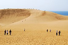
- Tottori Sand Dunes
- Uradome Coast (浦富海岸)[4][5][6][7]
Noted fauna and flora[]
- Pinus thunbergii, the Japanese black pine
- Japanese martin
- Black-tailed gull[1]
Related municipalities[]
See also[]
| Wikimedia Commons has media related to Sanin Kaigan National Park. |
References[]
- ^ Jump up to: a b c d "San'in Coast National Park". Encyclopedia of Japan. Tokyo: Shogakukan. 2012. Archived from the original on 25 August 2007. Retrieved 12 April 2012.
- ^ "San'inkaigan National Park". Natural Parks Foundation. Retrieved 4 February 2012.
- ^ Sutherland, Mary; Britton, Dorothy (1995). National Parks of Japan. Kodansha. pp. 131–3.
- ^ "San'inkaigan National Park". Ministry of the Environment. Archived from the original on 8 February 2012. Retrieved 4 February 2012.
- ^ "Sanin Kaigan National Park". Kyōto Prefecture. Retrieved 4 February 2012.
- ^ "山陰海岸国立公園". Tottori Prefecture. Retrieved 4 February 2012.
- ^ "Sanin Kaigan". Hyōgo Prefecture. Retrieved 4 February 2012.
- ^ "Sanin Kaigan National Park - Basic Information". Ministry of the Environment. Archived from the original on 28 January 2013. Retrieved 4 February 2012.
External links[]
- (in English) Sanin Kaigan National Park
- (in Japanese) Sanin Kaigan National Park
- Map of Sanin Kaigan National Park
This article about a national/quasi-national park or protected area in Japan, or related topic is a stub. You can help Wikipedia by . |
Categories:
- IUCN Category II
- National parks of Japan
- Parks and gardens in Hyōgo Prefecture
- Parks and gardens in Kyoto Prefecture
- Parks and gardens in Tottori Prefecture
- Protected areas established in 1963
- 1963 establishments in Japan
- Japan protected area stubs