Kōchi Prefecture
This article needs additional citations for verification. (October 2018) |
Kōchi Prefecture
高知県 | |
|---|---|
| Japanese transcription(s) | |
| • Japanese | 高知県 |
| • Rōmaji | Kōchi-ken |
 Flag  Symbol | |
 | |
| Coordinates: 33°26′N 133°26′E / 33.433°N 133.433°ECoordinates: 33°26′N 133°26′E / 33.433°N 133.433°E | |
| Country | |
| Region | Shikoku |
| Island | Shikoku |
| Capital | Kōchi (city) |
| Subdivisions | Districts: 6, Municipalities: 34 |
| Government | |
| • Governor | Seiji Hamada |
| Area | |
| • Total | 7,103.93 km2 (2,742.84 sq mi) |
| Area rank | 18th |
| Population (December 1, 2011) | |
| • Total | 757,914 |
| • Rank | 45th |
| • Density | 106.68/km2 (276.3/sq mi) |
| ISO 3166 code | JP-39 |
| Website | www |
| Symbols | |
| Bird | Fairy pitta (Pitta nympha) |
| Flower | Yamamomo (Myrica rubra) |
| Tree | Yanase Sugi (Cryptomeria japonica) |

Kōchi Prefecture (高知県, Kōchi-ken, /ˈkoʊtʃi/; pronounced [koːtɕi ꜜkeɴ]) is a prefecture of Japan located on the island of Shikoku.[1] Kōchi Prefecture has a population of 757,914 (1 December 2011) and has a geographic area of 7,103 km2 (2,742 sq mi). Kōchi Prefecture borders Ehime Prefecture to the northwest and Tokushima Prefecture to the northeast.
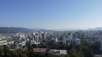
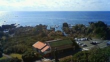
Kōchi is the capital and largest city of Kōchi Prefecture, with other major cities including Nankoku, Shimanto, and Kōnan.[2] Kōchi Prefecture is located on Japan's Pacific coast surrounding a large bay in the south of Shikoku, with the southernmost point of the island located at Cape Ashizuri in Tosashimizu. Kōchi Prefecture is home to Kōchi Castle, considered the most intact Japanese castle, and the Shimanto River, one of the few undammed rivers in Japan.
History[]
Kōchi Prefecture was historically known as Tosa Province and was controlled by the Chōsokabe clan in the Sengoku period and the Yamauchi clan during the Edo period.[3]
Kōchi city is also the birthplace of noted revolutionary Sakamoto Ryōma, who became one of the main instigators of the Meiji Restoration.
Geography[]
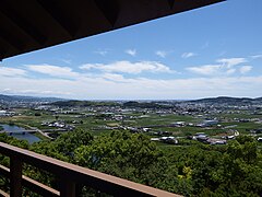
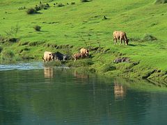
Kōchi Prefecture comprises the southwestern part of the island of Shikoku, facing the Pacific Ocean. It is bordered by Ehime to the north-west and Tokushima to the north-east. It is the largest but least populous of Shikoku's four prefectures. Most of the province is mountainous, and in only a few areas such as around Kōchi and Nakamura is there a coastal plain. Kōchi is famous for its many rivers. Inamura-yama in Tosa-cho is the highest peak in Kōchi prefecture with an altitude of 1,506 meters above sea level.
As of April 1, 2012, 7% of the total land area of the prefecture was designated as Natural Parks, namely the Ashizuri-Uwakai National Park; Ishizuchi, Muroto-Anan Kaigan, and Tsurugisan Quasi-National Parks; and eighteen Prefectural Natural Parks.[4]

City Town Village

Cities[]
Eleven cities are located in Kōchi Prefecture:
| Flag | Name | Area (km2) | Population | Map | |
|---|---|---|---|---|---|
| Rōmaji | Kanji | ||||
 |
Aki | 安芸市 | 317.34 | 17,810 | 
|
 |
Kami | 香美市 | 537.95 | 26,526 | 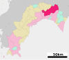
|
 |
Kōchi (capital) | 高知市 | 309.22 | 332,059 | 
|
 |
Kōnan | 香南市 | 126.75 | 32,786 | 
|
 |
Muroto | 室戸市 | 248.25 | 14,006 | 
|
 |
Nankoku | 南国市 | 125.35 | 47,776 | 
|
 |
Shimanto | 四万十市 | 632.42 | 34,433 | 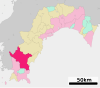
|
 |
Sukumo | 宿毛市 | 286.11 | 21,097 | 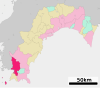
|
 |
Susaki | 須崎市 | 135.46 | 22,508 | 
|
 |
Tosa | 土佐市 | 91.59 | 27,602 | 
|
 |
Tosashimizu | 土佐清水市 | 266.54 | 14,666 | 
|


Towns and villages[]
These are the towns and villages in each district:
| Name | Area (km2) | Population | District | Type | Map | |
|---|---|---|---|---|---|---|
| Rōmaji | Kanji | |||||
| 芸西村 | 39.63 | 3,846 | Aki District | Village | ||
| 日高村 | 44.88 | 4,896 | Takaoka District | Village | ||
| いの町 | 470.71 | 22,155 | Agawa District | Town | ||
| 北川村 | 196.18 | 1‚328 | Aki District | Village | ||
| 黒潮町 | 188.38 | 11,559 | Hata District | Town | ||
| 三原村 | 85.35 | 1,627 | Hata District | Village | ||
| 本山町 | 134.21 | 3,605 | Nagaoka District | Town | ||
| 奈半利町 | 28.32 | 3,359 | Aki District | Town | ||
| 中土佐町 | 193.19 | 7,156 | Takaoka District | Town | ||
| 仁淀川町 | 332.96 | 5,676 | Agawa District | Town | ||
| 越知町 | 111.58 | 5,847 | Takaoka District | Town | ||
| 大川村 | 95.28 | 521 | Tosa District | Village | ||
| 大豊町 | 314.94 | 4,950 | Nagaoka District | Town | ||
| 大月町 | 103.03 | 5,719 | Hata District | Town | ||
| 佐川町 | 101.21 | 13,223 | Takaoka District | Town | ||
| 四万十町 | 642.06 | 18,269 | Takaoka District | Town | ||
| 田野町 | 6.56 | 2,644 | Aki District | Town | ||
| 土佐町 | 212.11 | 3,997 | Tosa District | Town | ||
| 東洋町 | 74.09 | 2,598 | Aki District | Town | ||
| 津野町 | 197.85 | 5,680 | Takaoka District | Town | ||
| 馬路村 | 165.48 | 737 | Aki District | Village | ||
| 安田町 | 53.03 | 2,614 | Aki District | Town | ||
| 梼原町 | 236.51 | 3,640 | Takaoka District | Town | ||


Mergers[]
Tourism[]

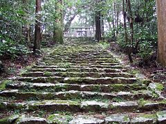
- Kōchi Castle, one of only 12 original castles left in Japan
- Okō Castle, Chōsokabe clan`s prime castle ruins now Kōchi Prefectural Museum of History is on site.
- , one of Japan's top three caves
- Shimanto River, the only undammed river in Japan
- Godaisan
- Anpanman Museum
Media[]
The 2013 movie Hospitality Department (Kencho Omotenashi Ka) is set in Kōchi.[5] The film shows views of Kōchi Prefecture.
The 2009 movie The Harimaya Bridge starring Danny Glover was set in Kochi.[6][7]
Culture[]

Food[]
Like most areas of Japan, Kōchi advertises itself as specialising in a major food item, in this case, katsuo no tataki. Katsuo no tataki is skipjack tuna or bonito, lightly seared.[8] Traditionally this is done over the straw generated as a by-product of the rice harvest.
Sawachi is a term which refers to "a style of meal" in Kochi prefecture, according to Kochi-City Tourism Association. It says that the characteristic of the style of eating is "its freeness in the arrangement of food on a large dish" People eat Sawachi in the situation of "Enkai" which refers to a gathering of family, friends and relatives. They surround "Sawachi", feasts on large dishes, and take own portions by themselves. The style represents the cultural climate of Kochi prefecture which hates formal arrangements and respect freedom.
Festival and events[]
- Festival
- Yosakoi Festival - Yosakoi (よさこい) is a unique style of dance that originated in Japan and that is performed at festivals and events all over the country.
Sports[]
The sports teams listed below are based in Kōchi.
- Baseball
- Football
See also[]
Notes[]
- ^ Nussbaum, Louis-Frédéric. (2005). "Kōchi prefecture" in Japan Encyclopedia, p. 538, p. 538, at Google Books.
- ^ Nussbaum, "Kōchi" at p. 538, p. 538, at Google Books.
- ^ Nussbaum, "Provinces and prefectures" at p. 780, p. 780, at Google Books.
- ^ "General overview of area figures for Natural Parks by prefecture" (PDF). Ministry of the Environment. Retrieved 19 August 2012.
- ^ "Yukiyo Teramoto Makes Short Insert Anime for "Prefectural Office Hospitality Department: The Movie" - Tokyo Otaku Mode News". otakumode.com.
- ^ Matt Alt; Hiroko Yoda; Melinda Joe (27 March 2012). Frommer's? Japan Day by Day. John Wiley & Sons. p. 532. ISBN 978-0-470-90826-6.
- ^ Iris-Aya Laemmerhirt (March 2014). Embracing Differences: Transnational Cultural Flows between Japan and the United States. transcript Verlag. p. 254. ISBN 978-3-8394-2600-5.
- ^ Lafferty, Jefferey (2020-10-16). "Japan's delicious fire-seared delicacy". BBC.
References[]
- Nussbaum, Louis-Frédéric and Käthe Roth. (2005). Japan encyclopedia. Cambridge: Harvard University Press. ISBN 978-0-674-01753-5; OCLC 58053128
External links[]
![]() Media related to Kōchi prefecture at Wikimedia Commons
Media related to Kōchi prefecture at Wikimedia Commons
- Official website (in English)

| show Authority control |
|---|
- Kōchi Prefecture
- Shikoku region
- Prefectures of Japan